River Nethan

Last updated

Nathan
River Nethan - geograph.org.uk - 1235334.jpg
Location
Country Scotland
Physical characteristics
Source 
  location Glenbuck, East Ayrshire, Scotland
  coordinates 55°32′N3°59′W / 55.533°N 3.983°W / 55.533; -3.983
Mouth River Clyde
  location
Crossford, South Lanarkshire, Scotland
  coordinates
55°42′00″N3°52′15″W / 55.70000°N 3.87083°W / 55.70000; -3.87083 Coordinates: 55°42′00″N3°52′15″W / 55.70000°N 3.87083°W / 55.70000; -3.87083
Length20.92 km (13.00 mi) [1]

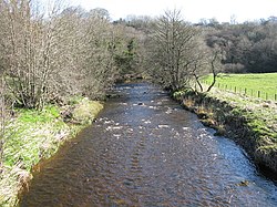
The River Nethan is a river which flows between Glenbuck in East Ayrshire and Crossford, South Lanarkshire where it feeds into the River Clyde, with the town of Lesmahagow and surrounding villages sitting on the river course. The area of woodland surrounding the River Nethan at Crossford and Auchenheath has been declared a site of special scientific interest and forms a part of the Clyde Valley Woodlands National Nature Reserve as Nethan Gorge. Craignethan Castle, a 16th-century fortification, overlooks the river.

Related Research Articles

Lanarkshire Historic county in Scotland

Lanarkshire, also called the County of Lanark, is a historic county, lieutenancy area and registration county in the central Lowlands of Scotland.

Cathcart Human settlement in Scotland

Cathcart is an area of Glasgow between Battlefield, Mount Florida, King's Park, Muirend and Newlands. The White Cart Water flows through Cathcart, downstream from Linn Park. In 2014, it was rated one of the most attractive postcode areas to live in Scotland.

Erskine Post town in Renfrewshire, Scotland

Erskine is a town in the council area of Renfrewshire, and historic county of the same name, situated in the West Central Lowlands of Scotland. It lies on the southern bank of the River Clyde, providing the lowest crossing to the north bank of the river at the Erskine Bridge, connecting the town to Old Kilpatrick in West Dunbartonshire. Erskine is a commuter town at the western extent of the Greater Glasgow conurbation, bordering Bishopton to the west and Renfrew, Inchinnan, Paisley and Glasgow Airport to the south. Originally a small village settlement, the town has expanded since the 1960s as the site of development as an overspill town, boosting the population to over 15,000. In 2014, it was rated one of the most attractive postcode areas to live in Scotland.

Falls of Clyde (waterfalls)

The Falls of Clyde is the collective name of four linn on the River Clyde near New Lanark, South Lanarkshire, Scotland. The Falls of Clyde comprise the upper falls of Bonnington Linn, Corra Linn, Dundaff Linn, and the lower falls of Stonebyres Linn. Corra Linn is the highest, with a fall of 26 metres (84 ft). Bonnington Linn, Corra Linn and Dundaff Linn are above New Lanark and located within the Falls of Clyde Reserve managed by the Scottish Wildlife Trust, a national nature conservation charity. Stonebyres Linn is located several miles downstream from the reserve and New Lanark.

Catacol Human settlement in Scotland

Catacol is a small village on the Isle of Arran, Scotland.

Clyde Walkway

The Clyde Walkway is a foot and mountain bike path which runs from Glasgow, Scotland, to just above the UNESCO World Heritage Site of New Lanark. The path runs close to the River Clyde for most of its length. It was completed in 2005, and is now designated as one of Scotland's Great Trails by NatureScot. The route is 65 kilometres (40 mi) long, and combines rural sections on the upper Clyde in South Lanarkshire, including the Clyde Valley Woodlands National Nature Reserve and the Falls of Clyde, with urban walking through the centre of Glasgow. About 155,000 people use the path every year, of whom about 7,750 undertake multi-day journeys including those covering the entire route.

Craignethan Castle 16th century Scottish Castle

Craignethan Castle is a ruined castle in South Lanarkshire, Scotland. It is located above the River Nethan, a tributary of the River Clyde, at NS816464. The castle is two miles west of the village of Crossford, and 4.5 miles north-west of Lanark. Built in the first half of the 16th century, Craignethan is recognised as an excellent early example of a sophisticated artillery fortification, although its defences were never fully tested.

Crossford is a village in West Fife, Scotland. It is 1 mile west of Dunfermline, east of Cairneyhill, astride the A994, at 56°03′51″N03°29′47″W.

Tillietudlem is a fictional castle in Walter Scott's 1816 novel Old Mortality, and a modern settlement in South Lanarkshire, Scotland.

Cuningar Loop

The Cuningar Loop is a meander on the River Clyde in Scotland which was converted to a woodland park in the mid-2010s. It lies within the territory of Rutherglen, South Lanarkshire, directly east of the district of Dalmarnock in Glasgow.

Crossford is a village in South Lanarkshire, Scotland.

Clyde River, Prince Edward Island Rural municipality in Prince Edward Island, Canada

Clyde River is a rural municipality in Prince Edward Island, Canada. Clyde River is located in Queens County in the central part of Prince Edward Island and just 15 minutes away from Charlottetown. The original community name was Dog River. It was named after the River Clyde in Scotland. Heritage is predominantly Scottish and English.

Cleghorn Glen

Cleghorn Glen is a site of special scientific interest which lies outside Lanark and Cleghorn in South Lanarkshire, Scotland. It is one of the six ancient woodlands, along with Cartland Craigs, Falls of Clyde, Chatelherault, Nethan Gorge and Mauldslie Woods, which make up the Clyde Valley Woodlands National Nature Reserve.

Clyde Valley Woodlands National Nature Reserve

The Clyde Valley Woodlands National Nature Reserve (NNR) comprises six separate woodland sites in the Clyde Valley region of South Lanarkshire, Scotland. These six sites are located along a 12 km section of the River Clyde and its tributaries, and lie close to built-up areas such as Hamilton and Lanark on the southern outskirts of Greater Glasgow. The sites can be easily accessed by about two million people living in the surrounding urban areas, making the reserve unique amongst Scotland's NNRs, most of which tend to be located in more remote areas. The six sites are:

Nethan Gorge is a natural gorge carved by the River Nethan, in South Lanarkshire, Scotland.

Mauldslie Woods is an area of woodland close to the town of Carluke, South Lanarkshire. It is one of six woodlands which form the Clyde Valley Woodlands National Nature Reserve, the others being Cartland Craigs, Chatelherault, Cleghorn Glen, Falls of Clyde and Lower Nethan Gorges. It stands on the estate of Mauldslie Castle, whose most notable resident was John Wightman of Mauldslie, Lord Provost of Edinburgh 1721/23.

Mouse Water

Mouse Water is a river in South Lanarkshire which is a tributary of the River Clyde. It is popular with canoeists. In the past, the fast flowing river was used to power mills and factories along its route and is still used today to produce hydroelectricity.

Bodinbo Island

Bodinbo Island is an islet in the estuarine waters of the River Clyde close to the old ferry slipway at Erskine. Before the dyke or training wall was built the rocky Bodinbo Island was a prominent feature in the river hereabouts and a hazard to shipping, especially sailing craft in the dark, during foggy weather, flood conditions and in high winds. On Ordnance Survey maps the name has been transliterated to Bottombow Island and Boden Boo is the spelling variant used for the nearby woodland plantation.

Clydesdale West (ward)

Clydesdale West is one of the twenty wards used to elect members of the South Lanarkshire Council. Created in 2007, it elects four councillors. Its territory covers the small town of Carluke and the surrounding rural area which includes the villages of Braidwood, Crossford and Law – these boundaries were unaffected by a 2017 national review. In 2019, the ward had a population of 19,124.

References

  1. "Nethan, River". The Gazetteer for Scotland. scottish-places.info. Retrieved 14 December 2011.