
Lanarkshire, also called the County of Lanark, is a historic county, lieutenancy area and registration county in the central Lowlands of Scotland.

Dunoon is the main town on the Cowal peninsula in the south of Argyll and Bute, Scotland. It is located on the western shore of the upper Firth of Clyde, to the south of the Holy Loch and to the north of Innellan. As well as forming part of the council area of Argyll and Bute, Dunoon also has its own community council. Dunoon was a burgh until 1976.
The Gorbals is an area in the city of Glasgow, Scotland, on the south bank of the River Clyde. By the late 19th century, it had become densely populated; rural migrants and immigrants were attracted by the new industries and employment opportunities of Glasgow. At its peak, during the 1930s, the wider Gorbals district had swollen in population to an estimated 90,000 residents. Along with its relatively small size, this gave the area a very high population density of around 40,000/km². Redevelopment after WWII has taken many turns, and the area's population is substantially smaller today.

Blantyre is a town and civil parish in South Lanarkshire, Scotland, with a population of 16,900. It is bounded by the River Clyde to the north, the Rotten Calder to the west, the Park Burn to the east and the Rotten Burn to the south.

Glasgow Green is a park in the east end of Glasgow, Scotland, on the north bank of the River Clyde. Established in the 15th century, it is the oldest park in the city.

The Erskine Bridge is a multi span cable-stayed box girder bridge spanning the River Clyde in west central Scotland. The bridge connects West Dunbartonshire with Renfrewshire and can be used by all types of motor vehicles, cyclists and pedestrians. As well as crossing the Clyde, the bridge also crosses the Forth and Clyde Canal and the North Clyde railway line. A small part of Kilpatrick railway station is situated underneath the bridge at the north side. The bridge is part of the A898 road. On completion the bridge replaced the Erskine to Old Kilpatrick ferry service.
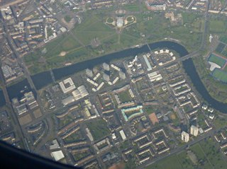
Hutchesontown is an inner-city area in Glasgow, Scotland. Mostly residential, it is situated directly south of the River Clyde and forms part of the wider historic Gorbals district, which is covered by the Southside Central ward under Glasgow City Council.

Laurieston is a district in the Gorbals area of the Scottish city of Glasgow. It is situated south of the River Clyde. It derives its name from James Laurie who, along with his brother, developed a large part of the district in the early 19th century.

Stirling railway station is a railway station located in Stirling, Scotland. It is located on the former Caledonian Railway main line between Glasgow and Perth. It is the junction for the branch line to Alloa and Dunfermline via Kincardine and is also served by trains on the Edinburgh to Dunblane Line and long-distance services to Dundee and Aberdeen and to Inverness via the Highland Main Line.

The Forth and Clyde canal pathway runs between the Firth of Forth and the Firth of Clyde and is a 106-kilometre-long (66 mi) footpath and cycleway that runs across Scotland, between Bowling, west of Glasgow, and Lochrin Basin in Edinburgh. The path runs on the towpaths of the Forth & Clyde and Union Canals and is entirely off road. The path is well maintained and its surface is generally good, although there are some stretches particularly between Falkirk and the outskirts of Edinburgh where wet weather leads to muddy conditions unsuitable for road intended bicycles. It is well used by walkers and cyclists, and designated as one of Scotland's Great Trails by NatureScot. It also forms part of the National Cycle Network, being designated as Route 754. Sustrans advises that the path is best followed from the Clyde to the Forth because the prevailing wind is from the south west. Much of the path is also suitable for experienced horseriders, although in some places low bridges, narrow aqueducts and gates may restrict access for horses.

Bridge Street railway station, now disused, was the original Glasgow terminus of the Glasgow and Paisley Joint Railway; jointly owned by the Glasgow, Paisley and Greenock Railway (GP&G), which later merged with the Caledonian Railway, and the Glasgow, Paisley, Kilmarnock and Ayr Railway (GPK&A), which became part of the Glasgow & South Western Railway.

The A730 road in Scotland runs between the centre of Glasgow and the south-eastern edge of the city's urban area at Cathkin.
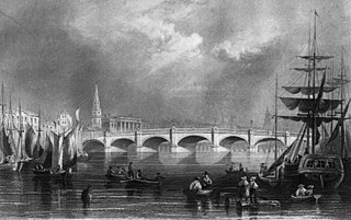
The Glasgow Bridge spans the River Clyde in Glasgow linking the city centre to Laurieston, Tradeston and Gorbals. Formerly known as Broomielaw Bridge, it is at the bottom of Jamaica Street near Central Station, and is colloquially known as the Jamaica Bridge.

The Polmadie Bridge is a footbridge that crosses the River Clyde, Glasgow, Scotland between Glasgow Green to its north, and Oatlands to its south.

Victoria Bridge is a category A listed road bridge spanning the River Clyde in Glasgow, Scotland. Victoria Bridge is the oldest surviving bridge in Glasgow, lying at the foot of Stockwell Street in the city centre.

Auchenshuggle Bridge is a road bridge spanning the River Clyde in Glasgow, Scotland. The Auchenshuggle Bridge is the latest bridge to be built over the Clyde in the Auchenshuggle district of Glasgow, carrying the M74 motorway over the river and onto land which is part of Clydebridge Steelworks in Rutherglen, en route to the M8 junction near the heavily congested Kingston Bridge.

The Albert Bridge is a road bridge that spans the River Clyde in Glasgow, Scotland, near Glasgow Green. The bridge opened in 1871. It links the Saltmarket in the city centre with Crown Street on the city’s south side. It is category A listed, and named after Queen Victoria's consort, Prince Albert.

The Clydebridge Steelworks, also known as Clydebridge Works, is a steel works in South Lanarkshire, Scotland.

Glasgow Bridge is the site of a road bridge over the Forth and Clyde Canal; it is also the site of a Roman fortlet, on the Antonine Wall, half way between the Roman forts at Kirkintilloch and Cadder.

Royal Terrace is a grand street in the city of Edinburgh, Scotland, on the north side of Calton Hill within the New Town and part of the UNESCO World Heritage Site inscribed in 1995, built on the south side of a setted street, facing the sloping banks of London Road Gardens, formerly Royal Terrace Gardens, with views looking north towards Leith and the Firth of Forth.

