


This is a list of the longest rivers of the United Kingdom.
This is a list of the longest rivers of the United Kingdom.
| Rank | River | Length (miles) | Length (km) | Mean Flow (m3/s) [1] | Mouth | Country |
|---|---|---|---|---|---|---|
| 1 | River Severn [2] | 220 | 354 | 107.4 | Severn Estuary | Wales/England |
| 2 | River Thames [2] | 215 | 346 | 65.4 | Thames Estuary | England |
| 3 | River Trent [2] | 185 | 297 | 89.0 | The Humber | England |
| 4 | River Wye [3] | 155 | 250 | 73.1 | Severn Estuary | Wales/England |
| 5 | River Great Ouse [2] | 143 | 230 | 15.6 | The Wash | England |
| 6 | River Ure/River Ouse, Yorkshire | 129 | 208 | 69.8 | The Humber | England |
| 7 | River Tay [2] | 117 | 188 | 179.0 | Firth of Tay | Scotland |
| 8 | River Clyde | 109 | 176 | 48.5 | Firth of Clyde | Scotland |
| 9 | River Spey | 107 | 172 | 65.7 | Moray Firth | Scotland |
| 10 | River Nene [2] | 100 | 161 | 9.3 | The Wash | England |
| 11 | River Bann / Lough Neagh | 99 | 159 | 92.2 | Atlantic Ocean | Northern Ireland |
| 12 | River Tweed [2] | 96 | 155 | 81.7 | North Sea | Scotland/England |
| 13 | River Avon, Warwickshire | 96 | 154 | 17.3 | River Severn* | England |
| 14 | River Eden, Cumbria | 90 | 145 | 53.7 | Solway Firth | England |
| 15 | River Dee, Aberdeenshire | 87 | 140 | 47.8 | North Sea | Scotland |
| 16 | River Witham | 82 | 132 | 5.2 | The Wash | England |
| 17 | River Teme | 81 | 130 | 18.2 | River Severn* | Wales/England |
| 18= | River Don, Aberdeenshire [2] | 80 | 129 | 21.3 | North Sea | Scotland |
| 18= | River Foyle | 80 | 129 | 58.8 | Atlantic Ocean | Northern Ireland/Republic of Ireland |
| 20 | River Usk [4] | 78 | 125 | 28.6 | Severn Estuary | Wales |
| 21 | River Teifi [5] | 76 | 122 | 29.5 | Cardigan Bay | Wales |
| 22= | River Tywi | 75 | 121 | 39.9 | Carmarthen Bay | Wales |
| 22= | River Ribble | 75 | 120 | 34.0 | Irish Sea | England |
| 22= | River Avon, Bristol | 75 | 120 | 22.2 | Mouth of the Severn | England |
| 25= | River Tyne [2] | 73 | 118 | 45.2 | North Sea | England |
| 25= | River Swale | 73 | 118 | 20.2 | River Ure | England |
| 27 | River Derwent, Yorkshire | 72 | 115 | 17.4 | River Ouse, Yorkshire | England |
| 28= | River Aire | 71 | 114 | 36.5 | River Ouse, Yorkshire | England |
| 28= | River Nith | 71 | 114 | 36.5 | Solway Firth | Scotland |
| 30= | River Tees | 70 | 113 | 22.2 | North Sea | England |
| 30= | River Medway | 70 | 113 | 11.7 | Thames Estuary | England |
| 30= | River Mersey | 70 | 113 | 37.1 | Irish Sea | England |
| 33= | River Dee, Wales [2] | 70 | 112 | 34.1 | Dee Estuary | Wales/England |
| 33= | River Don, South Yorkshire | 70 | 112 | 16.3 | River Ouse, Yorkshire | England |
There seems to be little consensus in published sources as to the lengths of rivers, nor much agreement as to what constitutes a river. Thus the River Ure and River Ouse can be counted as one river system or as two rivers. If it is counted as one, the River Aire/ River Ouse/Humber system would come fourth in the list, with a combined length of 161 miles (259 km); and the River Trent/Humber system would top the list with their combined length of 222 miles (357 km). [6] Also, the Thames tributary, the River Churn, sourced at Seven Springs, adds 14 miles (23 km) to the length of the Thames (from its traditional source at Thames Head). The Churn/Thames' length at 229 miles (369 km) is therefore greater than the Severn's length of 220 miles (354 km). Thus, the combined Churn/Thames river would top the list. Sue Owen et al., in their book on rivers, generally restrict the length to the parts that bear the same name. Thus the River Nene is quoted at 100 miles (160 km), but would be around 5 miles (8 km) more if the variously named sources were included. Many of the above lengths are considerably different from Sue Owen's list, some longer and some shorter. [2]
Where a river ends in an estuary the conventional British approach has been to treat the river as ending at the end of the administrative zone. Thus the Severn ends at the mouth of the Bristol Avon and the Thames at the Yantlet Line. The currently accepted end of the Severn Estuary is about 18.5 miles (29.8 km) further, and the Port of London's authority stretches now to Margate, 30 miles (48 km) further. Other countries have different conventions, making comparisons of limited value. Those rivers which empty into other (non-tidal sections of) rivers are indicated in the table thus*. In Yorkshire, the Aire, Derwent and Don all empty into a tidal section of the Yorkshire Ouse.
The figures for mean flow are derived from those offered up by the National River Flow Archive, in particular the flow measured at the lowermost gauging stations on each named watercourse. Sometimes the figures of further downstream tributaries are combined with those of the main stem river to provide a more realistic flow figure for the lowermost non-tidal stretch of a watercourse. Some major UK rivers (in terms of flow) are omitted from the list above simply because they are also short.
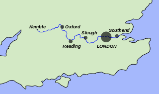
The River Thames, known alternatively in parts as the River Isis, is a river that flows through southern England including London. At 215 miles (346 km), it is the longest river entirely in England and the second-longest in the United Kingdom, after the River Severn.

The River Severn, at 220 miles (354 km) long, is the longest river in Great Britain. It is also the river with the most voluminous flow of water by far in all of England and Wales, with an average flow rate of 107 m3/s (3,800 cu ft/s) at Apperley, Gloucestershire. It rises in the Cambrian Mountains in mid Wales, at an altitude of 2,001 feet (610 m), on the Plynlimon massif, which lies close to the Ceredigion/Powys border near Llanidloes. The river then flows through Shropshire, Worcestershire and Gloucestershire. The county towns of Shrewsbury, Worcester and Gloucester lie on its course.

The Humber is a large tidal estuary on the east coast of Northern England. It is formed at Trent Falls, Faxfleet, by the confluence of the tidal rivers Ouse and Trent. From there to the North Sea, it forms part of the boundary between the East Riding of Yorkshire on the north bank and North Lincolnshire on the south bank. Although the Humber is an estuary from the point at which it is formed, many maps show it as the River Humber.
Water transport played a vital role in the UK's industrial development. The beginning of the 19th century saw a move from roads to waterways,.

The River Ouse is a river in North Yorkshire, England. Hydrologically, the river is a continuation of the River Ure, and the combined length of the River Ure and River Ouse makes it, at 129 miles (208 km), the sixth-longest river of the United Kingdom and the longest to flow entirely in one county. The length of the Ouse alone is about 52 miles (84 km) but the total length of the river is disputed.

The Derwent is a river in Yorkshire in the north of England. It flows from Fylingdales Moor in the North York Moors National Park, east then southwards as far as its confluence with the River Hertford then westwards through the Vale of Pickering, south through Kirkham Gorge and the Vale of York, joining the River Ouse at Barmby on the Marsh. The confluence is unusual in that the Derwent converges on the Ouse at a shallow angle in an upstream direction.

The River Wye is the fourth-longest river in the UK, stretching some 250 kilometres from its source on Plynlimon in mid Wales to the Severn Estuary. For much of its length the river forms part of the border between England and Wales. The Wye Valley is designated an Area of Outstanding Natural Beauty. The Wye is important for nature conservation and recreation, but is affected by pollution.

The River Churn is a tributary of the River Thames in central England. It rises at Seven Springs in Gloucestershire and flows south for approximately 37.3 km (23.2 mi) to meet the Thames at Cricklade in Wiltshire. Its length from its source to the confluence with the Thames is greater than that of the Thames from Thames Head, but the Churn is regarded as a tributary, rather than the main river.

The headwater of a river or stream is the farthest point on each of its tributaries upstream from its mouth/estuary into a lake/sea or its confluence with another river. Each headwater is considered one of the river's sources, as it is the place where surface runoffs from rainwater, meltwater and/or spring water begin accumulating into a more substantial and consistent flow that becomes a first-order tributary of that river. The tributary with the longest course downstream of the headwaters is regarded as the main stem.

A tidal bore, often simply given as bore in context, is a tidal phenomenon in which the leading edge of the incoming tide forms a wave of water that travels up a river or narrow bay, reversing the direction of the river or bay's current. It is a strong tide that pushes up the river, against the current.

The Severn Estuary is the estuary of the River Severn, flowing into the Bristol Channel between South West England and South Wales. Its very high tidal range, approximately 50 feet (15 m), creates valuable intertidal habitats and has led to the area being at the centre of discussions in the UK regarding renewable tidal energy.
The Market Weighton Canal ran 9.5 miles (15.3 km) from the Humber Estuary to its terminus near Market Weighton. It gained its Act of Parliament in 1772 and opened in 1782. The 3.5 miles (5.6 km) closest to Market Weighton was abandoned in 1900 and the right of navigation through Weighton lock was lost in 1971. However, as of 2002 the lock was passable and the canal usable up to the junction with the River Foulness where silt has made it impassable. Also there is no right of navigation under the M62 motorway bridge to the north of Newport.

The Severn Way is a waymarked long-distance footpath in the United Kingdom, which follows the course of the River Severn through Mid Wales and western England.
The River Cleddau consists of the Eastern and Western Cleddau rivers in Pembrokeshire, west Wales. They unite to form the Daugleddau estuary and the important harbour of Milford Haven.

The Rivers Trust (RT) is an environmental charity No. 1107144, and an umbrella organisation for 60 member trusts concerned with rivers in England, Wales, Northern Ireland and Ireland. The Trust's headquarters are in Callington, Cornwall. The Rivers Trust along with its members work to protect, promote and enhance freshwater ecosystems for both people and wildlife.

Seven Springs is a hamlet in the heavily wooded parish of Coberley in the Cotswold District of Gloucestershire in England, 4 miles (6.4 km) south of Cheltenham. Including the intersection of the A435 and A436 roads, it has the sources of the River Churn, which flows south across almost a full cross-section of the Cotswolds, through Cirencester, and joins the Thames near Cricklade.