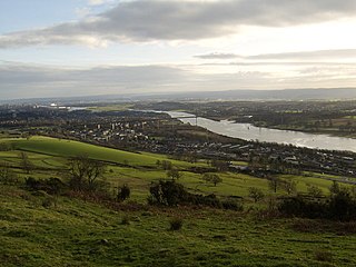
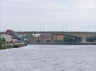
The River Clyde is a river that flows into the Firth of Clyde in Scotland. It is the ninth-longest river in the United Kingdom, and the second-longest in Scotland. It runs through the major city of Glasgow. Historically, it was important to the British Empire because of its role in shipbuilding and trade. To the Romans, it was Clota, and in the early medieval Cumbric language, it was known as Clud or Clut. It was central to the Kingdom of Strathclyde.
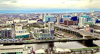
Glasgow is the most populous of the eight cities of Scotland and is the third-most populous city in the United Kingdom, as well as being the 27th largest city by population in Europe. In 2022, it had an estimated population as a defined locality of 632,350 and anchored an urban settlement of 1,028,220. Formed as a county of itself in 1893, the city had previously been in the historic county of Lanarkshire and has also grown to include settlements that were once part of Renfrewshire and Dunbartonshire. It now forms the Glasgow City Council area, one of the 32 council areas of Scotland, and is administered by Glasgow City Council.

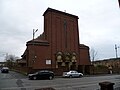
Maryhill is an area in the north-west of Glasgow in Scotland. A former independent burgh and the heart of an eponymous local authority ward, its territory is bisected by Maryhill Road, part of the A81 road which runs for a distance of roughly three miles between Glasgow city centre and the suburban town of Bearsden.
The Gorbals is an area in the city of Glasgow, Scotland, and former burgh, on the south bank of the River Clyde. By the late 19th century, it had become densely populated; rural migrants and immigrants were attracted by the new industries and employment opportunities of Glasgow. At its peak, during the 1930s, the wider Gorbals district had swollen in population to an estimated 90,000 residents, giving the area a very high population density of around 100,000 per sq. mi. (40,000/km2). Redevelopment after WWII has taken many turns, and the area's population is substantially smaller today. The Gorbals was also home to 16 high rise flat blocks; only six are standing as of 2023, and two of them are set to come down in the next couple of years.
Clydebank is a town in West Dunbartonshire, Scotland. Situated on the north bank of the River Clyde, it borders the village of Old Kilpatrick to the west, and the Yoker and Drumchapel areas of the adjacent City of Glasgow immediately to the east. Depending on the definition of the town's boundaries, the suburban areas of Duntocher, Faifley and Hardgate either surround Clydebank to the north, or are its northern outskirts, with the Kilpatrick Hills beyond.

Barrhead is a town in East Renfrewshire, Scotland, thirteen kilometres (8 mi) southwest of Glasgow city centre on the edge of the Gleniffer Braes. At the 2011 census its population was 17,268.
Anderston is an area of Glasgow, Scotland. It is on the north bank of the River Clyde and forms the south western edge of the city centre. Established as a village of handloom weavers in the early 18th century, Anderston was an independent burgh of barony from 1824 until it was incorporated into the City of Glasgow in 1846.

Parkhead is a district in the East End of Glasgow. Its name comes from a small weaving hamlet at the meeting place of the Great Eastern Road and Westmuir Street. Glasgow's Eastern Necropolis cemetery was laid out in the area in 1847 beside the Gallowgate.

Bridgeton is a district to the east of Glasgow city centre. Historically part of Lanarkshire, it is bounded by Glasgow Green to the west, Dalmarnock to the east and south, Calton to the north-west at Abercromby Street/London Road and Broad street to the north-east.

Dennistoun is a mostly residential district in Glasgow, Scotland, located north of the River Clyde and in the city's east end, about 1+1⁄4 miles east of the city centre. Since 2017 it has formed the core of a Dennistoun ward under Glasgow City Council, having previously been a component of the East Centre ward.

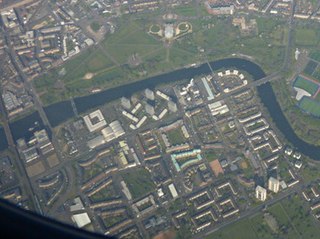
Whiteinch is an area in the city of Glasgow, Scotland. It is situated directly north of the River Clyde, between the Partick and Scotstoun areas of the city. Whiteinch was at one stage part of the burgh of Partick, until that burgh's absorption into the expanding city of Glasgow in 1912, and part of the Parish of Govan.

Shieldhall is a district in the Scottish city of Glasgow. It is situated directly south of the River Clyde and is part of the wider Govan area.
Hutchesontown is an inner-city area in Glasgow, Scotland. Mostly residential, it is situated directly south of the River Clyde and forms part of the wider historic Gorbals district, which is covered by the Southside Central ward under Glasgow City Council.
James Robert Rhind, architect, was born in Inverness, Scotland in 1854 and trained as an architect in his father's local practice.
The Glasgow Inner Ring Road was a proposed ring road encircling the city centre of Glasgow, Scotland. Construction of the roads began in 1965, and half of its circumference was completed by 1972, but no subsequent construction was made and the remaining plans were formally abandoned in 1980. After 30 years, a route following roughly the southern section of the proposals have also been created as the new M74.

Charing Cross is a major road junction and area within the centre of Glasgow, Scotland. It is situated north of the River Clyde at the intersection of Sauchiehall Street, St George's Road, Woodlands Road, North Street and Newton Street, as well as being at a major interchange of the M8 motorway. Charing Cross marks the notional boundary between the City Centre and the West End of the city.

John Rhind was an architect from Inverness, Scotland.
The architecture of Scotland includes all human building within the modern borders of Scotland, from the Neolithic era to the present day. The earliest surviving houses go back around 9500 years, and the first villages 6000 years: Skara Brae on the Mainland of Orkney being the earliest preserved example in Europe. Crannogs, roundhouses, each built on an artificial island, date from the Bronze Age and stone buildings called Atlantic roundhouses and larger earthwork hill forts from the Iron Age. The arrival of the Romans from about 71 AD led to the creation of forts like that at Trimontium, and a continuous fortification between the Firth of Forth and the Firth of Clyde known as the Antonine Wall, built in the second century AD. Beyond Roman influence, there is evidence of wheelhouses and underground souterrains. After the departure of the Romans there were a series of nucleated hill forts, often utilising major geographical features, as at Dunadd and Dunbarton.
Glasgow City Centre is the central business district of Glasgow, Scotland. Is bounded by Saltmarket, High Street and Castle Street to the east, The River Clyde to the south and the M8 motorway to its west and north. Glasgow City Centre is composed of the areas of Garnethill, Blythswood Hill and Merchant City as well as parts of Cowcaddens, Townhead, Anderston and Calton.

Sandyford is an area of Glasgow, Scotland. It is north of the River Clyde and forms part of the western periphery of the city centre. Formerly the name of a ward under Glasgow Town Council in the first part of the 20th century, it is within a continuous area of fairly dense urban development bordering several other neighbourhoods whose mutual boundaries have blurred over time, and is possibly less well known than all of the places which adjoin it, particularly Anderston and Finnieston.