
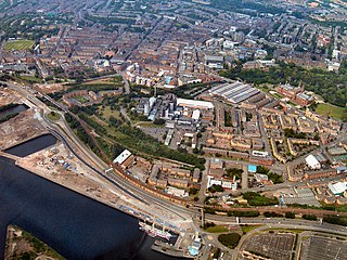
Glasgow is the most populous city in Scotland, the third-most populous city in the United Kingdom, and the 27th-most populous city in Europe. In 2022, it had an estimated population as a defined locality of 632,350 and anchored an urban settlement of 1,028,220. Formed as a county of itself in 1893, the city had previously been in the historic county of Lanarkshire and has also grown to include settlements that were once part of Renfrewshire and Dunbartonshire. It now forms the Glasgow City Council area, one of the 32 council areas of Scotland, and is administered by Glasgow City Council.
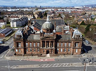
Govan is a district, parish, and former burgh now part of south-west Glasgow, Scotland. It is situated 2+1⁄2 miles west of Glasgow city centre, on the south bank of the River Clyde, opposite the mouth of the River Kelvin and the district of Partick. Historically it was part of the County of Lanark.
The Gorbals is an area in the city of Glasgow, Scotland, and former burgh, on the south bank of the River Clyde. By the late 19th century, it had become densely populated; rural migrants and immigrants were attracted by the new industries and employment opportunities of Glasgow. At its peak, during the 1930s, the wider Gorbals district had swollen in population to an estimated 90,000 residents, giving the area a very high population density of around 100,000 per sq. mi. (40,000/km2). Redevelopment after WWII has taken many turns, and the area's population is substantially smaller today. The Gorbals was also home to 16 high rise flat blocks; only six are standing as of 2024, and two of them are set to come down in the next couple of years.

Scotstoun is an area of Glasgow, Scotland, west of Glasgow City Centre. It is bounded by Garscadden and Yoker to the west, Victoria Park, Jordanhill and Whiteinch to the east, Jordanhill to the north and the River Clyde to the south. At the heart of Scotstoun lies Scotstounhill, an enclave of late Victorian and post-war housing centred on Scotstounhill railway station. Scotstoun is home to BAE Systems Surface Ships, and to the Glasgow Warriors rugby team.

Strathbungo is a mainly residential area of southern Glasgow, Scotland, bordered by the neighbourhoods of Crossmyloof to the south, Govanhill to the east and Pollokshields to the north and west. The settlement grew up as a small isolated village built along the Pollokshaws Road, one of the main arteries leading southwards from the centre of Glasgow, adjoined by the Camphill Estate, now part of Queens Park. Strathbungo lay just inside Govan parish, on its boundary with Cathcart parish, and at one time a line just north of Allison Street and Nithsdale Street formed the boundary or 'march' between the counties of Lanark and Renfrew.
Glasgow Govan was a parliamentary constituency in the Govan district of Glasgow. It was represented in the House of Commons of the Parliament of the United Kingdom for 120 years; from 1885 until 2005, returning one Member of Parliament (MP) elected by the first-past-the-post system.

Craigton is a residential suburb in the southwest of the city of Glasgow, Scotland. Located approximately three miles from the city centre, it is bordered by Bellahouston Park to the south and Halfway to the west, with Cardonald beyond.

This article deals with the history of the city of Glasgow, Scotland.

Possilpark is a district in the Scottish city of Glasgow, situated north of the River Clyde and centred around Saracen Street. The area developed around Saracen Foundry of Walter MacFarlane & Co., which was the main employer. In the wake of the Saracen Foundry's closure in 1967, this part of Glasgow became one of the poorest in the United Kingdom, and decades later deprivation and crime rates remain high.
Yorkhill is an area in the city of Glasgow, Scotland. It is situated north of the River Clyde in the West End of the city. It is known for its famous hospitals and remains the location of the West Glasgow Ambulatory Care Hospital.

Langside is a district in the Scottish city of Glasgow. It is situated south of the River Clyde, and lies east of Shawlands, south of Queens Park, west of Cathcart and north of Newlands. The district is residential and primarily middle-class, and has become an increasingly fashionable address in recent years. Housing stock is mainly of the Victorian tenement type, along with some townhouses of the same period.
Kinning Park is a southern suburb of Glasgow, Scotland. It was formerly a separate police burgh between 1871 and 1905 before being absorbed by the city. In 1897, it had a population of 14,326.

Dalmuir is an area nine miles northwest of Glasgow, Scotland, on the western side of Clydebank, and part of West Dunbartonshire Council Area. The name is a lowland Scots derivation of the Gaelic meaning Big Field. The area was originally two separate villages with Dalmuir Shore joining with Clydebank in 1886 and Dalmuir Village in 1906, during a period of rapid industrialization and expansion. Dalmuir is bounded by the village of Old Kilpatrick to the west, the Mountblow and Parkhall housing schemes to the north, and the Clydebank town centre area to the east. To the south is the River Clyde.
Braidfauld is a small area of Glasgow, Scotland which is in the East End of the city slightly north of the River Clyde and south of the Tollcross area. It was also the name of the 45th ward of Glasgow City Council, prior to the re-organisation into multi-member wards in 2007.
The Polloc and Govan Railway was an early mineral railway near Glasgow in Scotland, constructed to bring coal and iron from William Dixon's collieries and ironworks to the River Clyde for onward transportation.
Cessnock is an area in the city of Glasgow, Scotland. It is situated south of the River Clyde and was part of the former Burgh of Govan. Cessnock's main street is Paisley Road West, which runs west in the direction of Paisley and east through Kinning Park to Paisley Toll.

John Harper was a Scottish Baptist pastor who died in the sinking of the RMS Titanic in the North Atlantic Ocean.

Fireworks village, also known as Govan Colliery Houses, was a company village in Scotland belonging to the Dixon family who ran the Govan Iron Works and Govan Colliery. The inhabitants were chiefly coal miners and their families who worked in the Govan Colliery. The company also built a Methodist church and a school. At the time, its location was a short distance outside the City of Glasgow, the largest town in Scotland; no trace now remains in the 21st century, with the site occupied by the now inner-city neighbourhood of Govanhill

Kingston is an area of Glasgow, Scotland, from which the Kingston Bridge takes its name. Together with Ibrox, it forms one of the 56 neighbourhoods of Glasgow defined by Glasgow City Council for operational purposes. The area was assigned to Ward 54 until 2007 when it was reclassified as part of the Govan ward.

Moorepark is a small area in the Scottish city of Glasgow. Situated south of the River Clyde and part of the former Burgh of Govan, it was colloquially referred to as 'Wine Alley' during the mid-to-late 20th century when a housing scheme with a rough reputation was sited there. It is now an industrial estate.

