Busby, East Renfrewshire

Last updated

Busby
Main Street, Busby - geograph.org.uk - 1352552.jpg
Main Street in 2009
East Renfrewshire UK location map.svg
Red pog.svg
Busby
Glasgow UK location map.svg
Red pog.svg
Busby
Location within East Renfrewshire
East Renfrewshire UK location map.svg
Red pog.svg
Busby
Busby (East Renfrewshire)
Population3,310 (mid-2020 est.) [1]
Community council
  • Busby
Council area
Lieutenancy area
Country Scotland
Sovereign state United Kingdom
Post town GLASGOW
Postcode district G76 8
Dialling code 0141
Police Scotland
Fire Scottish
Ambulance Scottish
UK Parliament
Scottish Parliament
List of places
UK
Scotland
55°46′55″N4°16′02″W / 55.781834°N 4.267349°W / 55.781834; -4.267349

Busby is a village in East Renfrewshire, Scotland. [2] [3] Busby is in the same urban area as Glasgow, although it is administratively separate. It lies on the White Cart Water six miles (ten kilometres) south of Glasgow City Centre and 34 mile (1.2 kilometres) northwest of the outskirts of East Kilbride. It directly adjoins the town of Clarkston, with which the village is closely associated.

Contents

History

As a settlement, Busby dates back at least 700 years. Historically, the village was called Bushby. Its modern origins may be dated to several significant changes in the 1780s.

The first big change was in the landscape. Until the 1780s Busby village consisted of a scatter of cottages along a track leading from Carmunnock to Mearns. This route forded the River Cart near Newford.

This original village or fermtoun was in the area of the present Busby railway station. For centuries the occupants had worked the surrounding land from this central settlement. However, by the 1780s the landowner was in process of sweeping away the old fermtoun. The occupants were moved to the newly established farmsteads of Easter Busby, Wester Busby, Busbyside and Ryat. Busby as a village name could have disappeared, had it not been for events on the opposite side of the River Cart.

Cotton

The second big change started in 1780 with the founding of Busby's first cotton mill. This was at Newmill, on Cartsbridge lands on the opposite side of the River Cart. Busby and Newmill each had several earlier mills. Busby itself had Busby Meal Mill at the end of Field Road (founded before 1300), and Busby Waulk Mill in the Glen. Newmill also had two mills, situated together at the waterfall. The first was another early Meal Mill and the second a more recent Lint Mill. However, the cotton mill built in 1780 was on a completely different scale to the old rural mills. It attracted many families to settle in the area, and the centre of Busby swung from the old declining fermtoun on the Lanarkshire side of the River Cart, to Newmill on the Renfrewshire side.

A second Cotton Mill followed in 1790, then a Bleachfield and Printworks six years later. These industries provided the employment for the development of the modern village of Busby.

Paisley to East Kilbride road

The third major change in Busby in the 1780s was a new road from Paisley to East Kilbride, which went through the village. The first Busby Bridge was built on this route c.1785, and replaced an earlier ford above the waterfall. The new road changed the focus from the old Carmunnock—Mearns road to the Paisley—East Kilbride road.

Busby was never the perfect site for building a village, but developed due to the availability of water power on the River Cart. From the 1780s the village became centred on a hilly part of Cartsbridge Farm, originally known as "The Bank". Busby's Main Street was built on a very steep hill (although steep hills are very common in the area), and the road through to what is now Clarkston's town centre was built along a fragile slope which has collapsed several times since.

Railway age

Busby railway station in 1970 Busby railway station 1954897 9a85c608.jpg
Busby railway station in 1970

Another major wave of change occurred in Busby in the 1860s when the Printworks (now the Field Road industrial estate) brought the railway to Busby. Again the route to Busby was far from perfect, and the massive viaduct necessary to span Busby Glen was the most expensive structure on the line. Today the viaduct is an iconic feature of the area. The railway forced a change to the East Kilbride Road and the road bridge under the station still creates a hazard for heavy traffic on the main road. The bridge is particularly low, and has been hit by high buses in the past.

The railway brought a second wave of growth to Busby from the 1870s. The subsequent growth of the commuter suburb compensated for the decline of the Mills and Printworks. This ensured the survival of Busby into the twentieth and twenty-first centuries.

Points of interest

Parks

Busby contains multiple parks, the main ones being the large Busby Glen Park, at the east end of the aforementioned viaduct, Southview Park, and Spider Park.

Historic buildings

Most of the old buildings in west Busby (including almost all traces of the old mills) have been demolished or lost in some other way. However, one old building is left on Riverside Terrace. Busby's school and church are both very old, and much of the east part of Busby (historically the Lanarkshire side) is now a conservation area.

Busby Hotel is also a major local landmark. The building was refurbished extensively in 2014. [4] Old pubs in the area include The White Cart, which was built out of two different houses in east Busby, and the Cartvale pub on Busby's main street.

Notable people

Thomas Donohoe, a pioneer of football in Brazil, was born and raised in Busby. There is a sculpture in his honour at the car park in Mary Young Place. [5]

Clubs and organisations

Busby Lawn Tennis Club

Related Research Articles

<span class="mw-page-title-main">East Renfrewshire</span> Council area of Scotland

East Renfrewshire is one of 32 council areas of Scotland. It was formed in 1996, as a successor to the Eastwood district of the Strathclyde region. The northeastern part of the council area is close to Glasgow and many of the council area's northern settlements fall into the Greater Glasgow urban area.

<span class="mw-page-title-main">East Kilbride</span> Town in South Lanarkshire, Scotland

East Kilbride is the largest town in South Lanarkshire in Scotland, and the country's sixth-largest locality by population. It was also designated Scotland's first new town on 6 May 1947. The area lies on a raised plateau to the south of the Cathkin Braes, about eight miles southeast of Glasgow and close to the boundary with East Renfrewshire.

<span class="mw-page-title-main">Newton Mearns</span> Town in Scotland

Newton Mearns is a suburban town and the largest settlement in East Renfrewshire, Scotland. It lies 7 miles (11 km) southwest of Glasgow City Centre on the main road to Ayrshire, 410 feet (125 m) above sea level. It has a population of approximately 26,993, stretching from Whitecraigs and Kirkhill in the northeast to Maidenhill in the southeast, to Westacres and Greenlaw in the west and Capelrig/Patterton in the northwest.

<span class="mw-page-title-main">Carmunnock</span> Human settlement in Scotland

Carmunnock is a conservation village situated within the Glasgow City council area, lying within three miles of East Kilbride and Rutherglen in South Lanarkshire and Busby in East Renfrewshire. The nearest other district within Glasgow is Castlemilk.

<span class="mw-page-title-main">Netherlee</span> Human settlement in Scotland

Netherlee is a suburban residential area in East Renfrewshire, Scotland. It is situated on the west bank of the White Cart Water about 4 miles (6.5 km) south of Glasgow city centre. Part of the Greater Glasgow conurbation, it is mostly contiguous with the city, and is just beyond the boundary of its local authority area. It is a separate census locality from Glasgow, like other areas such as neighbouring Giffnock and Clarkston. Netherlee is directly contiguous with Stamperland. It is also in a council ward with Clarkston and its neighbour Busby. As of 2012, Netherlee has a population of 4,550.

Eaglesham is a village in East Renfrewshire, Scotland, situated about 10 miles (16 km) south of Glasgow, 3 miles (5 km) southeast of Newton Mearns and south of Clarkston, and 4 miles (6.4 km) southwest of East Kilbride.

<span class="mw-page-title-main">River Cart</span> River in Scotland

The River Cart is a tributary of the River Clyde, Scotland, which it joins from the west roughly midway between the towns of Erskine and Renfrew and opposite the town of Clydebank.

<span class="mw-page-title-main">Thornliebank</span> Human settlement in Scotland

Thornliebank is a suburban area in East Renfrewshire, in the west central Lowlands of Scotland. Part of the Greater Glasgow conurbation, it is located on the Auldhouse Burn about six miles south of Glasgow city centre, and just outside the city's administrative boundaries. The neighbouring East Renfrewshire town of Giffnock lies directly to the east, with Rouken Glen Park to the south.

<span class="mw-page-title-main">Muirend</span> Settlement in Scotland

Muirend is an area on the South side of Glasgow, Scotland. It is situated about 4 miles (6.5 km) south of Glasgow city centre. Muirend became extensively urbanised in the 20th century, developing into a commuter suburb. In a 2014 Royal Mail survey, the G44 postcode – which includes Muirend – was rated as the most desirable area of Scotland to live in. Neighbouring areas include Cathcart, Merrylee and Newlands in Glasgow, and Netherlee and Giffnock in East Renfrewshire. Some buildings that are locally associated with Muirend, including the main row of shops, as well as Hazelden Park and Muirend Pavilion, are located in East Renfrewshire. Notable residents include Sam McAulay amongst others.

<span class="mw-page-title-main">Stamperland</span> Human settlement in Scotland

Stamperland is a suburban neighbourhood in Clarkston, East Renfrewshire, Scotland. Part of the Greater Glasgow conurbation, it is situated on the west bank of the White Cart Water about 4.5 miles (7.2 km) south of Glasgow city centre, and just outside the city boundary.

<span class="mw-page-title-main">East Kilbride railway station</span> Railway station in South Lanarkshire, Scotland

East Kilbride railway station serves the town of East Kilbride, South Lanarkshire, Scotland. The station is managed by ScotRail and it is a terminus on the former Busby Railway. The station is 11+12 miles (18.5 km) southeast of Glasgow Central.

<span class="mw-page-title-main">Waterfoot, East Renfrewshire</span> Human settlement in Scotland

Waterfoot is a village in East Renfrewshire, Scotland. It is on the B767 road between Clarkston and Eaglesham, which are 1 mile (1.6 km) to the north and south respectively, while Newton Mearns is about 2 miles (3 km) to the west and East Kilbride about 5 miles (8 km) to the southeast. The village shares a community council with the neighbouring community of Eaglesham, the Eaglesham and Waterfoot Community Council meets in Eaglesham on a monthly basis.

<span class="mw-page-title-main">A726 road</span> Road in Scotland

The A726 road in Scotland is a major route with several distinct sections with different characteristics and names; owing to its stages of construction, since 2005 it has two separate parts, the first running between Strathaven in South Lanarkshire and Junction 5 of the M77 motorway south of Newton Mearns in East Renfrewshire via East Kilbride, and the other running between Junction 3 of the M77 and the M898 motorway near the Erskine Bridge, via Paisley and Junction 29 of the M8 motorway near Glasgow International Airport.

<span class="mw-page-title-main">A727 road</span> Road in Scotland

The A727 road in Scotland runs from East Kilbride in South Lanarkshire, through East Renfrewshire, to Junction 3 of the M77 motorway in Glasgow.

<span class="mw-page-title-main">Levern Water</span> River in Scotland

The Levern Water, is a small river in East Renfrewshire and Glasgow, Scotland. It rises in the Long Loch, and flows generally north and east, past the towns of Neilston and Barrhead, for a total distance of 9 miles (14 km). It empties into the White Cart River.

<span class="mw-page-title-main">Clarkston, East Renfrewshire</span> Human settlement in Scotland

Clarkston is a suburban town in East Renfrewshire, in the Central Lowlands of Scotland. A dormitory town with a population of around 10,000, Clarkston is on the southern fringe of the Greater Glasgow conurbation and directly adjoins the neighbouring suburban villages of Busby and Netherlee, as well as the towns of Newton Mearns and Giffnock.

<span class="mw-page-title-main">Busby Railway</span>

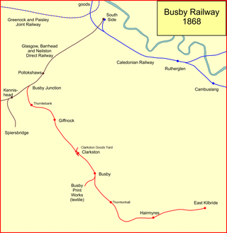
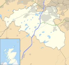
The Busby Railway is a short railway line built to the south of Glasgow, connecting the small villages of Thornliebank, Giffnock, Clarkston and Busby and later Thorntonhall and East Kilbride with the city. It opened in two stages, in 1866 and 1868, and served industry and encouraged residential development.

<span class="mw-page-title-main">Dams to Darnley Country Park</span>

Dams to Darnley Country Park is a 1350 acre country park in East Renfrewshire and Glasgow, in Scotland comprising the historic greenspace between the towns of Barrhead and Newton Mearns in East Renfrewshire, and the areas of Darnley, Parkhouse and Southpark Village in south Glasgow. Being designated since 2000, it is one of the newest country parks in Scotland.

Millhall is a hamlet in East Renfrewshire, in the Central Lowlands of Scotland. It lies 0.8 miles (1.3 km) southeast of Eaglesham, 8.3 miles (13.4 km) northwest of Strathaven and 3.6 miles (5.8 km) southwest of East Kilbride.

References

  1. "Mid-2020 Population Estimates for Settlements and Localities in Scotland". National Records of Scotland. 31 March 2022. Retrieved 31 March 2022.
  2. Ordnance Survey: Landranger map sheet 64 Glasgow (Motherwell & Airdrie) (Map). Ordnance Survey. 2010. ISBN   9780319228951.
  3. "Ordnance Survey: 1:50,000 Scale Gazetteer" (csv (download)). www.ordnancesurvey.co.uk. Ordnance Survey. 1 January 2016. Retrieved 30 January 2016.
  4. Hannah Thompson, "Scotland's Busby Hotel re-opens after £2.5m refurb", The Caterer, 31 October 2014.
  5. Photographs of the Busby Bust, May 2022