Lowther Hills

Last updated

The Lowther Hills, [1] also sometimes known as the Lowthers, are an extensive area of hill country in the Southern Uplands of Scotland, though some sub-ranges of hills in this area also go under their own local names - see "Hillwalking" below. They form a roughly rhomboidal or lozenge shape on the map with the acute angles being to north and south. It has river valleys along its boundaries to north east (Clydesdale) and south west (Nithsdale) which carry the two largest arterial routes northwards into the west side of the Central Belt of Scotland. A string of small towns have long since developed along these routes. Most of the Lowther Hills lie in the Administrative County of Dumfries and Galloway, though part in the administrative county of South Lanarkshire moves into them around the village of Leadhills and the Daer Reservoir.

Contents

View looking north into the Dalveen Pass from Capel Hill in the Durisdeer Hills with Steygail on the left, Lowther Hill left of centre and Cold Moss right of centre, Upper Dalveen House in the valley catching sunlight, Southern Uplands of Scotland. Dalveen Pass from Capel Hill.jpg
View looking north into the Dalveen Pass from Capel Hill in the Durisdeer Hills with Steygail on the left, Lowther Hill left of centre and Cold Moss right of centre, Upper Dalveen House in the valley catching sunlight, Southern Uplands of Scotland.

Etymology

There is some obscurity surrounding the name Lowther. [2] Derivation from the early Irish lothur meaning "a canal, a trench", [2] [3] in this sense "a pass between hills", [3] has been suggested. [2]

North-east and south-west boundaries

It is some 30 kilometres across the rhomboid as the crow flies from the town of Sanquhar just to the west of the Lowthers to the towns of Beattock and Moffat on the east and some 28 kilometres from the town of Thornhill near the southern apex to Abington near the northern one. Sanquhar and Thornhill lie on the River Nith, Moffat on the River Annan and Abington on the River Clyde. Annandale and Clydesdale taken together, form a corridor between the Lowther Hills and the Moffat Hills (which lie to the east.). This corridor between the hills carries the main route running northwards into Scotland on its west side. It carries both the west coast railway line and the M74 motorway and has been the main route north over centuries. Nithsdale to the west of the Lowthers carries both the A76 road and the rail line from Dumfries to Kilmarnock. The next range of hills to the west beyond the River Nith is the Carsphairn and Scaur Hills.

View into the Dalveen Pass (looking South) from Cold Moss in the Lowther Hills, Upper Dalveen House right foreground, Southern Uplands of Scotland. Dalveen Pass from Cold Moss.jpg
View into the Dalveen Pass (looking South) from Cold Moss in the Lowther Hills, Upper Dalveen House right foreground, Southern Uplands of Scotland.

North-west and south-east boundaries

The north west boundary of the hills runs up the Crawick Water in a north easterly direction from where the Crawick Water runs into the River Nith. This boundary follows the B740 road through Crawfordjohn and connects to the old trunk road north which was used before the M74 was built on its present route. North of the B740 the hills gradually drop out into the Central Lowlands of Scotland though Tinto is an outlier 11 kilometres north of Abington. The south east boundary of the hills is formed by the Forest of Ae which is one of the largest forests [4] in Britain at 10,000 hectares. A continuous band of trees runs, again in a north easterly direction, from Auldgirth on the River Nith (9 kilometres south of Thornhill), for some 26 kilometres till it meets the M74 motorway 10 kilometres north of Beattock. Continuing south of Ae leads into the plain that surrounds the town of Dumfries.

Hill Passes

Heading north on the ancient bridle path to the Enterkin Pass with Lowther Hill on left edge, Pettylung (Durisdeer Hills) on right and the Dalveen Pass between them. Southern Uplands of Scotland. Bridle Path to Enterkin Pass.jpg
Heading north on the ancient bridle path to the Enterkin Pass with Lowther Hill on left edge, Pettylung (Durisdeer Hills) on right and the Dalveen Pass between them. Southern Uplands of Scotland.

There are three road passes running in a north easterly direction diagonally through the Lowthers linking the A76 trunk road to the M74 motorway, and several 'ancient passes' now followed by paths or tracks.

Dalveen Pass

Dalveen Pass is the most southerly and the longest pass within the Lowther Hills. It runs from Carronbridge on the A76 just north of Thornhill to Elvanfoot near the M74 and carries the A702 trunk road. The road passes near the village of Durisdeer en route and reaches a height of 350 metres at the top of the pass. It is the only pass enlarged by ice into a U-shaped glacial trough, hence the road has to climb up the steep side to gain the head.

Mennock Pass

The Mennock Pass carries the B797 which runs from the small village of Mennock on the A76 to Abington near the M74, passing through the villages of Wanlockhead and Leadhills. The B797 reaches to a height of 467 metres as it leaves Wanlockhead - which is the highest village in Scotland. [5]

Roman Fortlet from Durisdeer Rig - Southern Uplands of Scotland. Roman Fortlet from Durisdeer Rig.jpg
Roman Fortlet from Durisdeer Rig - Southern Uplands of Scotland.

Crawick Pass

Crawick Pass is the most northerly of the three passes and carries the B740 from Crawick to Crawfordjohn and on to the M74. The Crawick is the shortest of the three passes without the steep ascents and overarching hills that characterise the other two. It is also the lowest of the three reaching a maximum height of 288 metres.

Ancient Passes

There was another pass from Durisdeer through to Wanlockhead called the Enterkin Pass which was an old pack horse route through the hills from Dumfries to Glasgow. It has been argued by H.R.G. Inglis (1924) [6] that this route was used mainly for extracting lead to the Solway coast and was never viable as a main route north because of its height. There is no road through there now though there is a track for walkers into the centre of the hills. The Enterkin Pass was the location of a 1684 Covenanter ambush of a party of Dragoons during the Killing Time [7] [8]

Durisdeer Hills from the A702. Durisdeer Village nestles into the foot of the glen in the middle of the picture and the Roman fortlet is at the foot of the glen just beyond the village. The hill catching the sunlight is Penbane with Well Hill beyond it also in sunlight, Black Hill is to the left and Durisdeer Hill to the right with its shoulder Durisdeer Rig running towards us. Durisdeer Hills Southern Uplands of Scotland. Durisdeer Hills from A702.jpg
Durisdeer Hills from the A702. Durisdeer Village nestles into the foot of the glen in the middle of the picture and the Roman fortlet is at the foot of the glen just beyond the village. The hill catching the sunlight is Penbane with Well Hill beyond it also in sunlight, Black Hill is to the left and Durisdeer Hill to the right with its shoulder Durisdeer Rig running towards us. Durisdeer Hills Southern Uplands of Scotland.

The Romans built a road through from their fortlet near Durisdeer [9] on a route which takes a more direct route to the head of the pass than is offered by the Dalveen Pass. Inglis calls this route Well Path and he considers this to have been on the main pilgrimage route from Edinburgh to Whithorn [10] and one of the main ancient routes northwards through the Southern Uplands.

Geology and Scenery of the Passes

The Lowther Hills are composed of resistant Ordovician shales, heavily compressed and contorted in the Caledonian mountain-building orogeny. The headwaters of the River Nith incise them deeply on the south, as the Nith falls much more steeply (to the nearby Solway Firth) than does the Clyde on the north. The flanks of the heavily glaciated Dalveen Pass and of the deep, steep-sided Enterkin Pass are both lined with rock slope failures (large landslips and landslides), [11] with a deep V-shaped notch linking these passes being a probable overflow channel cut by glacial meltwaters. The original source of the Clyde is inferred to have been here, captured to the Nith by the Dalveen trough-head.

Durisdeer and its Church

The village of Durisdeer sits at some distance from the A702, nestling tightly into the foot of Durisdeer Hill at the bottom of the pass through the hills that the Romans used. The Duke of Buccleuch, [12] the largest private landowner in Britain, [13] owns much of the land for many miles around this area and has a castle at Drumlanrig on the west bank of the River Nith some 5 kilometres north of Thornhill. In the church at Durisdeer [14] there is a mausoleum to the first Duke of Buccleuch complete with marble statues [15] of him and his wife Mary dating from 1713 though there has been a church on this site since medieval times.

Source of the Clyde

Source of the River Clyde (on the left of the picture) where the Daer Water (coming in from the top right) meets the Potrail Water (coming in from the middle of the right side), The A702 and Glenochar Farmhouse are in the foreground. Glenochar Bastle and Fermtoun are just out of the picture on the bottom right. Southern Uplands of Scotland. Source of the River Clyde.JPG
Source of the River Clyde (on the left of the picture) where the Daer Water (coming in from the top right) meets the Potrail Water (coming in from the middle of the right side), The A702 and Glenochar Farmhouse are in the foreground. Glenochar Bastle and Fermtoun are just out of the picture on the bottom right. Southern Uplands of Scotland.

Approaching Elvanfoot on the A702, Glenochar farmhouse is reached. Just to the north, there is Glenochar Bastle and Fermtoun [16] a 17th-century settlement and fortified house. The archaeological dig which revealed this was the winner of the 1997 Pitt Rivers Award for amateur archaeologists. Also, just to the south is the source of the River Clyde [17] which flows north through Lanarkshire and passes through the City of Glasgow. Where the Daer and Potrail Waters confluence, the River Clyde begins. The Daer Water has its head waters near Queensberry and it flows through Daer Reservoir before it meets the Potrail. The head waters of the Potrail are on the north east side of Durisdeer Hill.

God's Treasure House in Scotland

The fact that there are two villages nearly 500 metres up in a desolate hillside in the Southern Uplands of Scotland requires some explanation: because of the rich variety of minerals to be found here, this area became known as "God's Treasure House in Scotland". Notably, it has produced some of the world's purest gold (22.8 carats) which was used in the manufacture of the Scottish Crown Jewels [18] - dating from the 15th and 16th centuries. The name "Leadhills" testifies to the fact that this area was chiefly known for its lead mining; and there is a lead mining museum [19] in nearby Wanlockhead. Leadhills has the oldest subscription library in the UK (founded by miners in 1741), and was the birthplace of the 18th century poet Allan Ramsay, whose son, also Allan Ramsay, was the leading portrait painter in Britain in the mid 18th century. The Leadhills & Wanlockhead Railway [20] is a preserved former industrial narrow-gauge railway line.

Hillwalking

The Lowther Hills can be split into a northern and southern section. The northern section would generally be taken to mean the string of tops lying between the Dalveen Pass and the Mennock Pass and running south eastward from near Elvanfoot over Lousie Wood Law, White Law, Dun Law, Dungrain Law, Peden Head, Green Lowther, Lowther Hill, East Mount Lowther, Thirstane Hill and Steygail which dominates the steepest part of the Dalveen Pass on its northern side. Green Lowther is the highest point of the Lowther Hills area and, like Lowther Hill, has a Civil Aviation Authority aircraft tracking station on the summit. The huge white 'golf ball' on the top of Lowther Hill can be seen from many miles away in all directions. The Southern Upland Way passes over the top of Lowther Hill - the highest point of the entire route. [21] The southern portion would generally be taken to mean the lower but more expansive hills which lie between the Dalveen Pass and the Forest of Ae, the highest point of which is Queensberry. Mitchellslacks, on the northern edge of the Forest Ae, and which provides access to Queensberry, along with nearby Locherben, were the homes of the Harknesses involved in the Covenanter ambush. They also offer views into the northern Lowthers, Nithsdale and Annandale.

Lowther Hills from Scaw'd Law in the Durisdeer Hills. Lowther Hill (with ball on top) left of the ridge and Cold Moss in front of it, Green Lowther middle of the picture (also with masts on top), Dun Law one third in from right and Lousie Wood Law on right. Well Hill is the very prominent hill running across the picture much nearer to us and the Roman road also runs across the picture below Well Hill. The Roman road meets the A702 beyond Well Hill on the right of the picture. Potrail Water (one of the principal sources of the River Clyde) rises from little burns running out of the glen leading down from Scaw'd Law in the immediate foreground. The Southern Uplands of Scotland. Lowther Hills from Scaw'd Law.jpg
Lowther Hills from Scaw'd Law in the Durisdeer Hills. Lowther Hill (with ball on top) left of the ridge and Cold Moss in front of it, Green Lowther middle of the picture (also with masts on top), Dun Law one third in from right and Lousie Wood Law on right. Well Hill is the very prominent hill running across the picture much nearer to us and the Roman road also runs across the picture below Well Hill. The Roman road meets the A702 beyond Well Hill on the right of the picture. Potrail Water (one of the principal sources of the River Clyde) rises from little burns running out of the glen leading down from Scaw'd Law in the immediate foreground. The Southern Uplands of Scotland.

Snowsports

The Lowther Hills are one of the birthplaces of Scottish winter sports. Curling in the Lowthers can be traced back to 1777, when the Wanlockhead Curling Society –one of Scotland's first Curling societies- was created. Scotland's first boys' Curling club was established in Wanlockhead in 1883. The sport remained popular in the area until the 1930s. Since the 1920s skiing in the Lowther Hills has been organised intermittently by a succession of local residents as well as several non-for-profit sports clubs. Lowther Hill is home to the only ski area in the south of Scotland, and Scotland's only community-owned ski centre. Operated by Lowther Hills Ski Club, the ski centre runs three ski lifts above the villages of Leadhills and Wanlockhead for beginners and intermediate skiers. [22]

Related Research Articles

<span class="mw-page-title-main">Dumfries and Galloway</span> Council area of Scotland

Dumfries and Galloway is one of the 32 unitary council areas of Scotland, located in the western part of the Southern Uplands. It is bordered by East Ayrshire, South Ayrshire, and South Lanarkshire to the north; Scottish Borders to the north-east; the English ceremonial county of Cumbria, the Solway Firth, and the Irish Sea to the south, and the North Channel to the west. The administrative centre and largest settlement is the town of Dumfries. The second largest town is Stranraer, located 76 miles (122 km) to the west of Dumfries on the North Channel coast.

<span class="mw-page-title-main">Sanquhar</span> Human settlement in Scotland

Sanquhar is a village on the River Nith in Dumfries and Galloway, Scotland, north of Thornhill and west of Moffat. It is a former Royal Burgh.

<span class="mw-page-title-main">Thornhill, Dumfries and Galloway</span> Village in rural lowland Scotland

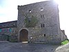
Thornhill is a village in the Mid Nithsdale area of Dumfries and Galloway, Scotland, south of Sanquhar and north of Dumfries on the main A76 road. Thornhill sits in the Nithsdale valley with the Carsphairn and Scaur range to the west and the Lowther hills to the east. It was initially a small village, planned and built in 1717 on the Queensberry Estate on the road linking Dumfries to Glasgow. The Earl of Queensberry initially named the village 'New Dalgarnock' however the name did not achieve popular approval.

<span class="mw-page-title-main">Dumfriesshire</span> Historic county in Scotland

Dumfriesshire or the County of Dumfries or Shire of Dumfries is a historic county and registration county in southern Scotland. The Dumfries lieutenancy area covers a similar area to the historic county.

<span class="mw-page-title-main">Nithsdale</span> Scottish local government district (1975–1996), part of Dumfries and Galloway region

Nithsdale, also known as Strathnith, Stranith or Stranit, is the strath or dale of the River Nith in southern Scotland. Nithsdale was one of the medieval provinces of Scotland. The provinces gradually lost their administrative importance to the shires created from the twelfth century, with Nithsdale forming part of Dumfriesshire. A Nithsdale district covering a similar area to the medieval province was created in 1975, based in the area's main town of Dumfries. The district was abolished in 1996, since when the area has been directly administered by Dumfries and Galloway Council.

<span class="mw-page-title-main">River Nith</span> River in south-west Scotland

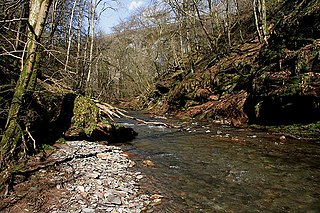
The River Nith is a river in south-west Scotland. The Nith rises in the Carsphairn hills of East Ayrshire, between Prickeny Hill and Enoch Hill, 4.4 miles (7.1 km) east of Dalmellington. For the majority of its 70 miles (110 km) course it flows in a south-easterly direction through Dumfries and Galloway and then into the Solway Firth at Airds Point.

<span class="mw-page-title-main">Southern Uplands</span> Southernmost and least populous region of Scotland

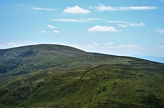
The Southern Uplands are the southernmost and least populous of mainland Scotland's three major geographic areas. The term is used both to describe the geographical region and to collectively denote the various ranges of hills and mountains within this region. An overwhelmingly rural and agricultural region, the Southern Uplands are partly forested and contain many areas of open moorland - the hill names in the area are congruent with these characteristics.

<span class="mw-page-title-main">Wanlockhead</span> Human settlement in Scotland

Wanlockhead is a village in Dumfries and Galloway, Scotland, nestling in the Lowther Hills and 1 mile south of Leadhills at the head of the Mennock Pass, which forms part of the Southern Uplands. It is Scotland's highest village, the village centre being at an elevation of around 405 m (1,329 ft) above sea level. Some sources, including VisitScotland, cite an altitude of 467 metres (1,532 ft) but the highest house in the village has been measured at 444 metres (1,457 ft).

<span class="mw-page-title-main">A76 road</span> Road in Scotland

The A76 is a major trunk road in south west Scotland.

The Leadhills and Wanlockhead Light Railway was a short branch railway built in Scotland to serve mining settlements, high in the Lowther Hills, connecting them to the Carlisle - Carstairs main line. The line was opened in 1901 - 1902, and was the highest standard gauge railway line in the British Isles. Hoped-for developments did not emerge, and when the world lead price slumped in the 1920s, the line sustained heavy losses. It was closed on 2 January 1939.

<span class="mw-page-title-main">Carsphairn and Scaur Hills</span> Hills in Scotland

The Carsphairn and Scaur Hills are the western and eastern hills respectively of a hill range in the Southern Uplands of Scotland. Ordnance Survey maps don't have a general name for the hill area as a whole. Also, Ordnance Survey use "Scar" rather than the local spelling of "Scaur" - the word is pronounced as "Scar" however. In their Landranger Series of maps, it requires four separate sheets to cover the area.

<span class="mw-page-title-main">Carron Water, Dumfriesshire</span>

The Carron Water is a tributary of the River Nith in southwest Scotland. It rises in the Dalveen Pass in the Lowther Hills as its headwater streams, the Dinabid Linn, Dalveen Lane and Lavern Burn join to flow southwards, to the west of the village of Durisdeer, to meet the Nith at Carronbridge.

<span class="mw-page-title-main">Daer Reservoir</span> Reservoir in South Lanarkshire, Scotland

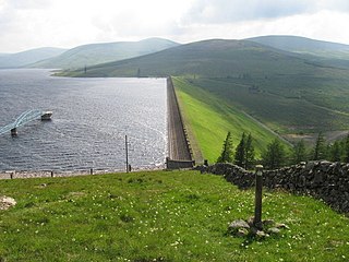
Daer Reservoir is a man-made waterbody created by the damming of the Daer Water, a tributary of the River Clyde in the Southern Uplands of Scotland. It lies within the Lowther Hills in South Lanarkshire. A minor public road leaving the A702 follows the Daer Water south to the dam and then continues along the western margin of the reservoir as far as Kirkhope. The reservoir was officially opened by Queen Elizabeth II in 1956 to supply water to the Scottish Central Belt.

Mennock is a small village or hamlet which lies 2 miles (3.2 km) south-east of Sanquhar on the A76, in Dumfriesshire, in the District Council Region of Dumfries and Galloway, southwest Scotland. Its original nucleus are the old smithy and corn mill with associated buildings. The site is dominated by the A76 that runs through the centre of Mennock. The village has expanded in recent years with housing on the River Nith side of the A76.

<span class="mw-page-title-main">Enterkinfoot</span> Human settlement in Scotland

Enterkinfoot is a small village or hamlet which lies 6 miles (9.7 km) north of Thornhill on the A76 on the route to Sanquhar, in Dumfriesshire, Durisdeer Parish, in Dumfries and Galloway, south-west Scotland. Its original nucleus was the old mill with associated buildings, the school and the famous Enterkin Pass and path that followed the course of the Enterkin Glen to Wanlockhead and from there to Edinburgh. The site features the A76 that runs through the centre of Enterkinfoot, the River Nith and the Enterkin Burn that once powered the mill before joining the Nith. The area is famous for its association with the Covenanters.

<span class="mw-page-title-main">Kirkbride, Durisdeer</span> Human settlement in Scotland

Kirkbride, previously Kilbride was an ancient parish close to the village of Enterkinfoot, the lands of which lay on both sides of the River Nith in the old Strathnith area of Dumfries and Galloway, Scotland, about 5 miles south of Sanquhar and north of Closeburn. The parish was suppressed and divided between Durisdeer and Sanquhar parishes in 1732. The ruins of the kirk are a scheduled monument and the surrounding graveyard is a Category B listed building with the River Nith in the valley below. The Ha Cleuch Burn flows through the glen that lies to the east of the site with a lane reaching it that runs up from Enterkinfoot, ending at Coshogle Farm.

<span class="mw-page-title-main">Lowther Hill</span>

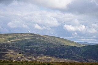
Lowther Hill is a hill in the Lowther Hills range, part of the Southern Uplands of Scotland. Although the hill lends its name to the range, it is the second highest point of the Lowther Hills and lies on the border between Lanarkshire and Dumfries and Galloway, east of the town of Sanquhar, however the true summit lies just within Lanarkshire. The hill can be seen from a great distance in almost every direction throughout the central Southern Uplands when at height, in part due to its summit being topped by a radar station owned by NATS, the radome being colloquially known as "the golf ball". Access to the station is via a private service road starting in Wanlockhead, the highest village in Scotland. Although motor vehicle access is restricted, the road is popular with hillwalkers and cyclists, using it as a means of easy access to the top of the hill or for recreation. Continuing on to the highest of the range, Green Lowther, it is the second highest paved road in Britain and the highest in Scotland. Lowther Hill is also the highest point of the 344 km Southern Upland Way, passing just short of the summit at around 710m.

<span class="mw-page-title-main">Scaw'd Law</span>

Scaw'd Law is a hill in the Lowther Hills range, part of the Southern Uplands of Scotland. The Dumfries and Galloway-South Lanarkshire border runs along its summit, which is notable for having two similar rounded tops; the top 300m to the north is likely the true summit. Surrounded on most sides by tracks or roads, there are various routes to the summit, but the most frequent ascents are from Durisdeer or the Daer Reservoir.

References

  1. Ordnance Survey Landranger Maps no. 78 Nithsdale and Annandale and no. 72 Upper Clyde Valley
  2. 1 2 3 Drummond, Peter; Stuart, Donald William (1991). Scottish Hill and Mountain Names: The Origin and Meaning of the Names of Scotland's Hills and Mountains. Scottish Mountaineering Trust. p. 63. ISBN   9780907521303.
  3. 1 2 "Place Names" (PDF). The Southern Upland Way place names. Retrieved 10 February 2019.
  4. Forestry Commission Scotland
  5. Ordnance Survey Mapzone
  6. Society of Antiquaries of Scotland Proceedings of the Society Feb 11th 1924 ANCIENT BORDER HIGHWAYS p. 221 by Harry R G Inglis Archived 12 June 2007 at the Wayback Machine
  7. Roots Web
  8. Travel Scotland
  9. Roman Britain
  10. Society of Antiquaries of Scotland Proceedings of the Society Feb 11th 1924 ANCIENT BORDER HIGHWAYS p. 219 by Harry R G Inglis Archived 12 June 2007 at the Wayback Machine
  11. "ROCK SLOPE FAILURE CLUSTERING AND SPARSITY IN THE BRITISH MOUNTAINS | David Jarman | 5 updates | 4 publications | Research Project".
  12. Times on Line Obituary 5 September 2007
  13. Buccleuch Estates
  14. Hope Cottage Durisdeer
  15. Scotland's Places
  16. Archaeology.co.UK
  17. Information Britain
  18. Rampant Scotland
  19. Museum of Lead Mining
  20. The Leadhills and Wanlockhead Railway
  21. Southern Upland Way
  22. "Lowther Hills Ski Club". Archived from the original on 26 February 2020. Retrieved 2 November 2017.

Further reading

55°24′N3°44′W / 55.40°N 3.74°W / 55.40; -3.74