The Merrick, or simply Merrick, is a mountain in the Range of the Awful Hand, a sub-range of the Galloway Hills range, part of the Southern Uplands of Scotland. The summit elevation is 843 metres, making it the highest mountain in the Southern Uplands and southern Scotland.

Leadhills, originally settled for the accommodation of miners, is a village in South Lanarkshire, Scotland, 5+3⁄4 miles (9.3 km) WSW of Elvanfoot. The population in 1901 was 835. It was originally known as Waterhead.

The Southern Uplands are the southernmost and least populous of mainland Scotland's three major geographic areas. The term is used both to describe the geographical region and to collectively denote the various ranges of hills and mountains within this region. An overwhelmingly rural and agricultural region, the Southern Uplands are partly forested and contain many areas of open moorland - the hill names in the area are congruent with these characteristics.

Wanlockhead is a village in Dumfries and Galloway, Scotland, nestling in the Lowther Hills and 1 mile south of Leadhills at the head of the Mennock Pass, which forms part of the Southern Uplands. It is Scotland's highest village, the village centre being at an elevation of around 405 m (1,329 ft) above sea level. Some sources, including VisitScotland, cite an altitude of 467 metres (1,532 ft) but the highest house in the village has been measured at 444 metres (1,457 ft).

The Southern Upland Way is a 344-kilometre (214 mi) coast-to-coast long-distance footpath in southern Scotland. The route links Portpatrick in the west and Cockburnspath in the east via the hills of the Southern Uplands. The Way is designated as one of Scotland's Great Trails by NatureScot and is the longest of the 29 Great Trails. The Southern Upland Way meets with seven of the other Great Trails: the Annandale Way, the Berwickshire Coastal Path, the Borders Abbeys Way, the Cross Borders Drove Road, the Mull of Galloway Trail, the Romans and Reivers Route and St Cuthbert's Way.

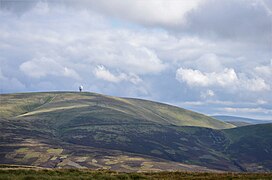
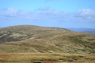
Broad Law is a hill in the Manor Hills range, part of the Southern Uplands of Scotland. The second-highest point in the Southern Uplands and the highest point in the Scottish Borders, it has an elevation of 840 metres, a prominence of 653 metres and an isolation of 81 kilometres. It is only 3 m (10 ft) lower than its parent, Merrick. Like many of its neighbours it is smooth, rounded and grassy, although the surrounding glens have very steep sides — country somewhat akin to the Cheviots or the Howgill Fells. The hill is most easily climbed from the Megget Stane to the south, beginning at an elevation of 452 m (1,483 ft), but is also frequently climbed from the villages near its base, or as part of a long, 50 km (30 mi) trek across the local area between the towns of Peebles and Moffat. On the summit is the highest VOR beacon in the UK, and also a radio tower.
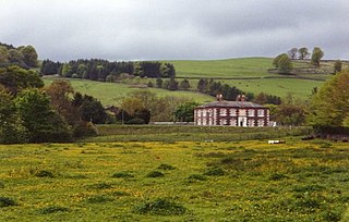
Beattock is a village in Dumfries and Galloway, Scotland, approximately 1⁄2 mile southwest of Moffat and 19 miles north of Dumfries.
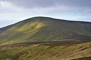
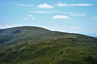
Culter Fell is a hill in the Culter Hills range, part of the Southern Uplands of Scotland. It is the county top of the historic county of Lanarkshire, as well as the highest point in South Lanarkshire council area. It is the culmination of a network of ridges that lie south of the village of Coulter, close to the town of Biggar.

White Coomb is a hill in the Moffat Hills range, part of the Southern Uplands of Scotland. Its broad summit is the highest point in the range and the registration county of Dumfriesshire, as well as being the fourth highest point in southern Scotland, however, despite this, it is largely concealed by other hills on all sides except its east and south east, making this the only direction from which its full scale can be seen.

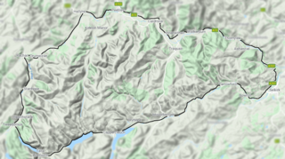
The Moffat Hills are a range of hills in the Southern Uplands of Scotland. They form a roughly triangular shape with a west facing side, a north facing side, and a south-east facing side. It is 17 kilometres from east to west across this triangle and some 16 kilometres north to south. The highest point is White Coomb at 821 m (2694 ft). The town of Moffat lies just south of the Moffat hills and along with Tweedsmuir, at the northern extremity, is the only centre of population around these hills. In some older maps, the northern part of the Moffat Hills is called the Tweedsmuir Hills, but can also be known by the title Manor Hills.

The Lowther Hills, also sometimes known as the Lowthers, are an extensive area of hill country in the Southern Uplands of Scotland, though some sub-ranges of hills in this area also go under their own local names - see "Hillwalking" below. They form a roughly rhomboidal or lozenge shape on the map with the acute angles being to north and south. It has river valleys along its boundaries to north east (Clydesdale) and south west (Nithsdale) which carry the two largest arterial routes northwards into the west side of the Central Belt of Scotland. A string of small towns have long since developed along these routes. Most of the Lowther Hills lie in the Administrative County of Dumfries and Galloway, though part in the administrative county of South Lanarkshire moves into them around the village of Leadhills and the Daer Reservoir.

The Cheviot Hills, or sometimes The Cheviots, are a range of uplands straddling the Anglo-Scottish border between Northumberland and the Scottish Borders. The English section is within the Northumberland National Park. The range includes The Cheviot, plus Hedgehope Hill to the east, Windy Gyle to the west, and Cushat Law and Bloodybush Edge to the south.
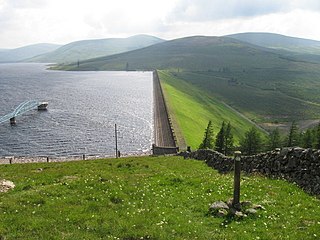
Daer Reservoir is a man-made waterbody created by the damming of the Daer Water, a tributary of the River Clyde in the Southern Uplands of Scotland. It lies within the Lowther Hills in South Lanarkshire. A minor public road leaving the A702 follows the Daer Water south to the dam and then continues along the western margin of the reservoir as far as Kirkhope. The reservoir was officially opened by Queen Elizabeth II in 1956 to supply water to the Scottish Central Belt.

Green Lowther is a hill in the Lowther Hills range, part of the Southern Uplands of Scotland. It is the highest point of the Lowther Hills and lies in Lanarkshire, east of the town of Sanquhar. A microwave array once stood at the summit, however a telecommunications mast remains next to a transmitter station. The private service road which makes its way up neighbouring Lowther Hill, continuing over Green Trough to the summit is the second highest paved road in Britain after Great Dun Fell in the Pennines and the highest road of any kind in Scotland.
Dollar Law is a hill in the Manor Hills range, part of the Southern Uplands of Scotland. The third highest in the range and the Scottish Borders and fifth highest in southern Scotland, it is frequently climbed with its neighbours Broad Law and Cramalt Craig to the southwest from their direction or as a detour from the hills to the northwest near Drumelzier. Thief's Road, a historic heritage path, passes just south of the summit.
The Manor Hills, also known as the Tweedsmuir Hills, are a range of hills south of Peebles in the Scottish Borders, one of the ranges which collectively form the Southern Uplands. They are separated from the Moffat Hills by the Talla Reservoir, Megget Reservoir and St. Mary's Loch, the Moorfoot Hills by the A72 and the Culter Hills in South Lanarkshire by the A701. The western portion of the hills are designated as the 'Tweedsmuir Hills' Site of Special Scientific Interest and the 'Upper Tweeddale' National Scenic Area, with the major tributary rivers designated as Special Areas of Conservation.
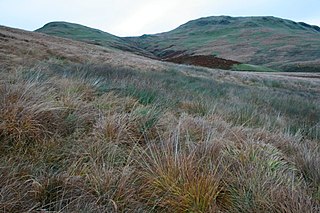
Scaw'd Law is a hill in the Lowther Hills range, part of the Southern Uplands of Scotland. The Dumfries and Galloway-South Lanarkshire border runs along its summit, which is notable for having two similar rounded tops; the top 300m to the north is likely the true summit. Surrounded on most sides by tracks or roads, there are various routes to the summit, but the most frequent ascents are from Durisdeer or the Daer Reservoir.
Earncraig Hill is a hill in the Lowther Hills range, part of the Southern Uplands of Scotland. The lowest and craggiest Donald hill in the range, it lies on the border between Dumfries and Galloway and South Lanarkshire, helping form the source of the River Clyde. It is most quickly ascended from the Daer Reservoir to the north or from Mitchellslacks to the south, passing by Burleywhag bothy.>