
The Ring of Fire is a region around much of the rim of the Pacific Ocean where many volcanic eruptions and earthquakes occur. The Ring of Fire is a horseshoe-shaped belt about 40,000 km (25,000 mi) long and up to about 500 km (310 mi) wide.
The Aleutian Range is a major mountain range located in southwest Alaska. It extends from Chakachamna Lake to Unimak Island, which is at the tip of the Alaska Peninsula. It includes all of the mountains of the Peninsula. The Aleutian Range is special because of its large number of active volcanoes, which are also part of the larger Aleutian Arc. The mainland part of the range is about 600 miles (1000 km) long. The Aleutian Islands are (geologically) a partially submerged western extension of the range that stretches for another 1,600 km (1000 mi). However the official designation "Aleutian Range" includes only the mainland peaks and the peaks on Unimak Island. The range is almost entirely roadless wilderness. Katmai National Park and Preserve, a large national park within the range, must be reached by boat or plane.

The Lassen volcanic area presents a geological record of sedimentation and volcanic activity in and around Lassen Volcanic National Park in Northern California, U.S. The park is located in the southernmost part of the Cascade Mountain Range in the Pacific Northwest region of the United States. Pacific Oceanic tectonic plates have plunged below the North American Plate in this part of North America for hundreds of millions of years. Heat and molten rock from these subducting plates has fed scores of volcanoes in California, Oregon, Washington and British Columbia over at least the past 30 million years, including these in the Lassen volcanic areas.

Novarupta is a volcano that was formed in 1912, located on the Alaska Peninsula on a slope of Trident Volcano in Katmai National Park and Preserve, about 290 miles (470 km) southwest of Anchorage. Formed during the largest volcanic eruption of the 20th century, Novarupta released 30 times the volume of magma of the 1980 eruption of Mount St. Helens.

Trident Volcano is an eroded volcanic complex on the Alaska Peninsula in Katmai National Park, Alaska. Up to 23 domes comprise the complex stratovolcano, with the greatest elevation of 6,115 feet (1,864 m). The most recent major activity produced a 3,599-foot (1,097 m) dome in an amphitheater on the southwest flank of the southwest peak. Volcano Novarupta formed on its slopes in the largest volcanic eruption of the 20th century.

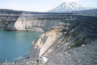
Mount Aniakchak is a 3,700-year-old volcanic caldera approximately 10 kilometers (6 mi) in diameter, located in the Aleutian Range of Alaska, United States. Although a stratovolcano by composition, the pre-existing mountain collapsed in a major eruption forming the caldera. The area around the volcano is the Aniakchak National Monument and Preserve, maintained by the National Park Service. In November 1967, Aniakchak Caldera was designated as a National Natural Landmark by the National Park Service.

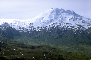
Redoubt Volcano, or Mount Redoubt, is an active stratovolcano in the largely volcanic Aleutian Range of the U.S. state of Alaska. Located at the head of the Chigmit Mountains subrange in Lake Clark National Park and Preserve, the mountain is just west of Cook Inlet, in the Kenai Peninsula Borough about 110 miles (180 km) southwest of Anchorage. At 10,197 feet (3,108 m), in just over 5 miles (8 km) Mount Redoubt attains 9,150 feet (2,700 m) of prominence over its surrounding terrain. It is the highest summit in the Aleutian Range. In 1976, Redoubt Volcano was designated as a National Natural Landmark by the National Park Service.

Mount Shishaldin is a moderately active volcano on Unimak Island in the Aleutian Islands chain of Alaska. It is the highest mountain peak of the Aleutian Islands. The most symmetrical cone-shaped glacier-clad large mountain on Earth, the volcano's topographic contour lines are nearly perfect circles above 6,500 feet (1,981 m). The lower north and south slopes are somewhat steeper than the lower eastern and western slopes. The volcano is the westernmost of three large stratovolcanoes along an east–west line in the eastern half of Unimak Island.
Chiginagak Volcano is a stratovolcano on the Alaska Peninsula, located about 15 km NW of Chiginagak Bay.
Mount Veniaminof is an active stratovolcano on the Alaska Peninsula. The mountain was named after Ioann Veniaminov (1797–1879), a Russian Orthodox missionary priest whose writings on the Aleut language and ethnology are still standard references. He is a saint of the Orthodox Church, known as Saint Innocent for the monastic name he used in later life.

Mount Akutan, officially Akutan Peak, is a stratovolcano in the Aleutian Islands of Alaska. Akutan Peak, at 4,275 feet (1,303 m), is the highest point on the caldera of the Akutan stratovolcano. Akutan contains a 2 km-wide caldera formed during a major explosive eruption about 1600 years ago. Recent eruptive activity has originated from a large cinder cone on the NE part of the caldera. It has been the source of frequent explosive eruptions with occasional lava effusion that blankets the caldera floor. A lava flow in 1978 traveled through a narrow breach in the north caldera rim to within 2 km of the coast. A small lake occupies part of the caldera floor. Two volcanic centers are located on the NW flank: Lava Peak is of Pleistocene age; and, a cinder cone lower on the flank which produced a lava flow in 1852 that extended the shoreline of the island and forms Lava Point. An older, mostly buried caldera seems to have formed in Pleistocene or Holocene time, while the current caldera formed in a VEI-5 eruption c. 340 AD. AVO has recorded 33 confirmed eruptions at Akutan, making it the volcano with the most eruptions in Alaska.

Mount Okmok is the highest point on the rim of Okmok Caldera on the northeastern part of Umnak Island in the eastern Aleutian Islands of Alaska. This 9.3 kilometers (5.8 mi) wide circular caldera truncates the top of a large shield volcano. The volcano is currently rated by the Alaska Volcano Observatory as Aviation Alert Level Green and Volcanic-alert Level Normal.

Mount Cleveland is a nearly symmetrical stratovolcano on the western end of Chuginadak Island, which is part of the Islands of Four Mountains just west of Umnak Island in the Fox Islands of the Aleutian Islands of Alaska. Mt. Cleveland is 5,675 ft (1,730 m) high, and one of the most active of the 75 or more volcanoes in the larger Aleutian Arc. Aleutian natives named the island after their fire goddess, Chuginadak, who they believed inhabited the volcano. In 1894 a team from the U.S. Coast and Geodetic Survey visited the island and gave Mount Cleveland its current name, after then-president Grover Cleveland.

Augustine Volcano is a stratovolcano in Alaska consisting of a central complex of summit lava domes and flows surrounded by an apron of pyroclastic, lahar, avalanche, and ash deposits. The volcano is frequently active, with major eruptions recorded in 1883, 1935, 1963–64, 1976, 1986, and 2006. Minor eruptive events were reported in 1812, 1885, 1908, 1944, and 1971. The large eruptions are characterized by an explosive onset followed by the quieter effusion of lava. It forms Augustine Island in southwestern Cook Inlet in the Kenai Peninsula Borough of southcentral coastal Alaska, 174 miles (280 km) southwest of Anchorage. Augustine Island has a land area of 32.4 square miles (83.9 km2), while West Island, just off Augustine's western shores, has 2 sq mi (5.2 km2). The irregular coastline of Augustine Island is due to the repeated catastrophic collapse of the summit dome, forming debris avalanches down the flanks and into Cook Inlet.

The Mount Meager massif is a group of volcanic peaks in the Pacific Ranges of the Coast Mountains in southwestern British Columbia, Canada. Part of the Cascade Volcanic Arc of western North America, it is located 150 km (93 mi) north of Vancouver at the northern end of the Pemberton Valley and reaches a maximum elevation of 2,680 m (8,790 ft). The massif is capped by several eroded volcanic edifices, including lava domes, volcanic plugs and overlapping piles of lava flows; these form at least six major summits including Mount Meager which is the second highest of the massif.

The Cascade Volcanoes are a number of volcanoes in a volcanic arc in western North America, extending from southwestern British Columbia through Washington and Oregon to Northern California, a distance of well over 700 miles (1,100 km). The arc formed due to subduction along the Cascadia subduction zone. Although taking its name from the Cascade Range, this term is a geologic grouping rather than a geographic one, and the Cascade Volcanoes extend north into the Coast Mountains, past the Fraser River which is the northward limit of the Cascade Range proper.

The Mount Edziza volcanic complex is a large and potentially active north-south trending complex volcano in Stikine Country, northwestern British Columbia, Canada, located 38 kilometres (24 mi) southeast of the small community of Telegraph Creek. It occupies the southeastern portion of the Tahltan Highland, an upland area of plateau and lower mountain ranges, lying east of the Boundary Ranges and south of the Inklin River, which is the east fork of the Taku River. As a volcanic complex, it consists of many types of volcanoes, including shield volcanoes, calderas, lava domes, stratovolcanoes, and cinder cones.

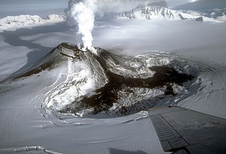
Alaska's Mount Redoubt volcano began erupting on March 22, 2009, and activity continued for several months.

The Gareloi Volcano is a stratovolcano in the Aleutian Islands of Alaska, United States, about 1,259 miles (2,026 km) from Anchorage. Gareloi is located on Gareloi Island, and comprises most of its land mass. The island also has two small glaciers which protrude to the northwest and southeast.
The Bridge River Vent is a volcanic crater in the Pacific Ranges of the Coast Mountains in southwestern British Columbia, Canada. It is located 51 km (32 mi) west of Bralorne on the northeastern flank of the Mount Meager massif. With an elevation of 1,524 m (5,000 ft), it lies on the steep northern face of Plinth Peak, a 2,677 m (8,783 ft) high volcanic peak comprising the northern portion of Meager. The vent rises above the western shoulder of the Pemberton Valley and represents the northernmost volcanic feature of the Mount Meager massif.
