
Uxbridge is a town in Worcester County, Massachusetts, United States,A first colonized in 1662 and incorporated in 1727. It was originally part of the town of Mendon, and named for the Earl of Uxbridge. The town is located 36 mi (58 km) southwest of Boston and 15 mi (24 km) south-southeast of Worcester, at the midpoint of the Blackstone Valley National Historic Park. The historical society notes that Uxbridge is the "Heart of The Blackstone Valley" and is also known as "the Cradle of the Industrial Revolution". Uxbridge was a prominent Textile center in the American Industrial Revolution. Two Quakers served as national leaders in the American anti-slavery movement. Uxbridge "weaves a tapestry of early America".

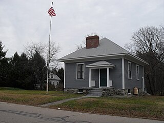
North Uxbridge is a village and a post office in the town (township) of Uxbridge in Worcester County, Massachusetts, United States. The postal zip code is 01538. It is classified as a community or populated place located at latitude 42.088 and longitude -71.641 and the elevation is 266 feet (81 m). North Uxbridge appears on the Uxbridge U.S. Geological Survey Map. Worcester County is in the Eastern time zone and observes DST. North Uxbridge is located about 36 miles WSW of Boston, and 15 miles SE of Worcester. The town meeting in 1885 set aside North Uxbridge as a "special district", since its population had exceeded 1000 people. North Uxbridge appeared to be a separate Census tract in the 1960 census with a population of 1882. In 2013, an Uxbridge DIY show, The Garage, with Steve Butler, went worldwide from Steve's garage in North Uxbridge.

Wheelockville is a village in the town (township) of Uxbridge, Massachusetts, United States. Part of the village centering on Mendon and Henry streets is listed on the National Register of Historic Places as the Wheelockville Historic District. Wheelockville appears on the Blackstone U.S. Geological Survey Map. The Village receives municipal services from Uxbridge, for fire, police, EMS, School district, public works, and other services. Worcester's Judicial District includes Uxbridge District Court. The geography of Wheelockville includes several other distinct mill villages, including: Hecla and Elmdale.
Ironstone is an historic village,, in the township of Uxbridge, Massachusetts, United States. It derived its name from plentiful bog iron found here which helped Uxbridge to become a center for three iron forges in the town's earliest settlement. South Uxbridge has historic sites, picturesque weddings, hospitality, industrial and distribution centers, and the new Uxbridge High School. This community borders North Smithfield, and Burrillville, Rhode Island, and Millville, Massachusetts. South Uxbridge receives municipal services from Uxbridge, for fire, police, EMS, School district, public works, and other services. There is a South Uxbridge fire station of the Uxbridge fire department. Worcester's Judicial District includes Uxbridge District Court. Ironstone appears on the Blackstone U.S. Geological Survey Map. Worcester County is in the Eastern time zone and observes DST.

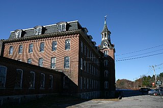
The Wheelockville District is an historic district located at Mendon and Henry streets in the village of Wheelockville in Uxbridge, Massachusetts. It encompasses a collection of modest Federal and Greek Revival period worker housing, built primarily to house families of workers at the nearby Waucantuck Mill Complex. The oldest houses in the area were built c. 1825–35, and include cottages built by the mill owners. A second phase of growth between about 1860 and 1885 resulted in the construction of a number of buildings with vernacular Victorian elements, as well as the somewhat more ornate Italianate Wheelock House at 173 Mendon Street, which was built for a manager at another Uxbridge mill. The district runs roughly along Mendon Street from Hecla Street to the junction of Mendon and Henry Streets, and then along those two streets for about six houses.
The Linwood Historic District is an industrial historic district in the Linwood village of Northbridge, Massachusetts. It is the site of the Linwood Cotton Mill and is roughly bounded by Linwood Avenue, Maple Court, and Pine Court. On June 16, 1989, it was added to the National Register of Historic Places.
The Somersville Historic District encompasses the historic components of the mill village of Somersville in western Somers, Connecticut, United States. The district is centered on a mill complex on the Scantic River, which divides the district. The most significant years of development were between about 1835 and 1935, although the area has a history dating to the 1760s. The district was listed on the National Register of Historic Places in 1995. The Mill itself has since burned down and as of October 2018 is currently open field, although the canal structure remains in place.

The Lower Highlands Historic District encompasses one of the oldest residential areas of Fall River, Massachusetts. The district is roughly bounded by Cherry, Main, Winter, and Bank Streets, and is located just east of the Downtown Fall River Historic District and directly south of the Highlands Historic District. This area was settled by 1810, has architecture tracing the city's growth as a major industrial center. The historic district was added to the National Register of Historic Places in 1984.

Farnumsville Historic District is a historic district encompassing a historic mill village in Grafton, Massachusetts. It is located on the eastern bank of the Blackstone River, extending along Providence and Main Streets, roughly between Cross and Depot Streets, and radiating along those roads and adjacent streets. This area was one of Grafton's 19th century industrial mill villages, which was centered on the Farnum Mill, which first began operating in the second decade of the 19th century. The main mill building that survives dates to 1844, and the housing stock in the village is in a diversity of styles, built roughly between the 1820s and 1920s.

The Hopedale Village Historic District encompasses much of the historic 19th century industrial village center of Hopedale, Massachusetts. Its main focus is the mill complex of the Draper Company at Hopedale and Freedom Streets; the district includes much of northern Hopedale, extending along Dutcher and Freedom Streets, and including the mill pond. It extends to the south just beyond Mendon Street, including properties on that street from the Milford line west to Hopedale Cemetery. The district was added to the National Register of Historic Places in 2002. The district has been included as part of the Blackstone River Valley National Historical Park.

The Rockdale Common Housing District is a historic district at 4-20 McBride, 46-58 Plantation, and 37-42 Taft Sts. in Northbridge, Massachusetts, United States. The district is composed of a collection of tenement houses built from c. 1880 to 1920. They were built by members of the Whitin family, who owned most of the textile production capacity in Northbridge. The district was added to the National Register of Historic Places in 1983.

The Ware Millyard Historic District encompasses a 19th-century mill complex and industrial mill village in the town of Ware, Massachusetts. It is roughly bounded by South Street, the Ware River, Upper Dam Complex, Park Street, Otis Avenue and Church Street. The area includes surviving mill buildings, the oldest of which date to the 1840s, and a collection of tenement-style housing built for the millworkers, built between 1845 and the 1880s.

The North Canal Historic District of Lawrence, Massachusetts, encompasses the historic industrial heart of the city. It is centered on the North Canal and the Great Stone Dam, which provided the waterpower for its many mill complexes. The canal was listed on the National Register of Historic Places in 1975, while the district was first listed in 1984, and then expanded slightly in 2009.

The Nashua Manufacturing Company Historic District in Nashua, New Hampshire, is a historic district that was listed on the National Register of Historic Places (NRHP) in 1987. It encompasses an area just west of downtown Nashua, roughly located along the southern bank of the Nashua River, bordered on the west side by Mine Falls Park, on the south side by the Nashua River canal, up to Ledge Street, and from the east side by Factory, Pine and Water streets, up to the Main Street bridge.

The Exeter Waterfront Commercial Historic District encompasses the historic commercial and residential waterfront areas of Exeter, New Hampshire. The district extends along the north side of Water Street, roughly from Main Street to Front Street, and then along both sides of Water and High streets to the latter's junction with Portsmouth Street. It also includes properties on Chestnut Street on the north side of the Squamscott River. This area was where the early settlement of Exeter took place in 1638, and soon developed as a shipbuilding center. The district was listed on the National Register of Historic Places in 1980. It was enlarged in 1986 to include the mill complex of the Exeter Manufacturing Company on Chestnut Street.

The Nashua Gummed and Coated Paper Company Historic District encompasses a collection of former industrial buildings on the north side of the Nashua River in Nashua, New Hampshire. Located on Franklin and Front Streets west of Main Street, the complex was developed by the Nashua Gummed and Coated Paper Company, later the Nashua Corporation, beginning in the late 19th century. It was a major manufacturing and employment center for the city until mid-1990s, when the company's business declined. One of its former storehouses was converted to residences in the 2000s, and the main complex is, in 2015-16, undergoing the same process. The complex of surviving buildings was listed on the National Register of Historic Places in 2015.

The Manchester Historic District encompasses a historic planned industrial and residential area of Manchester, Connecticut. Located west of the town's Main Street area, the district includes most of the Cheney Brothers Historic District, a National Historic Landmark District covering the silk manufacturing mills, worker housing, and owner residences of the Cheney family, as well as other surrounding residential areas related to the growth and development of Manchester under the Cheney's influence. The district was listed on the National Register of Historic Places in 2000.

The Union Village Historic District encompasses the core of a historic 19th-century residential mill village in Manchester, Connecticut. Radiating north and west from the junction of Union Street and North Main Street, the area was developed in the first half of the 19th century has a company town, but evolved into a mixed working-class community in the 20th century. It was listed on the National Register of Historic Places in 2002.

The South Willington Historic District is a historic district encompassing the historic village of South Willington in the town of Willington, Connecticut. The village, mostly stretched along Connecticut Route 32, developed as a 19th-century industrial mill village associated with the Gardiner Hall Jr. Company. The district was listed on the National Register of Historic Places in 2017.

The Manchaug Village Historic District is a historic district encompassing the 19th century industrial village center of Manchaug in Sutton, Massachusetts. Developed in the 1820s around textile mills on the Mumford River, it was the largest industrial area in Sutton, with at least three mill complexes in operation. The district is centered on the junction of Main Street with Manchaug, Putnam Hill, and Whitins Roads.


