Blacktop Peak

Last updated
Blacktop Peak
Alger basin from Koip peak.jpg
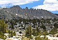
Blacktop right of center, from northwest
Highest point
Elevation 12,724 ft (3,878 m) [1]
Prominence 360 ft (110 m) [2]
Parent peak Kuna Peak (13,002 ft) [3]
Isolation 1.48 mi (2.38 km) [3]
Listing Vagmarken Club Sierra Crest List [4]
Coordinates 37°47′37″N119°11′46″W / 37.7937286°N 119.1961395°W / 37.7937286; -119.1961395 [1]
Geography
Relief map of California.png
Red triangle with thick white border.svg
Blacktop Peak
Location in California
Usa edcp relief location map.png
Red triangle with thick white border.svg
Blacktop Peak
Blacktop Peak (the United States)
Location Ansel Adams Wilderness
Mono County, California, U.S.
Parent range Sierra Nevada
Topo map USGS Koip Peak
Geology
Age of rock Cretaceous
Mountain type Fault block
Type of rock Metamorphic rock
Climbing
First ascent Unknown [5]
Easiest route class 2 [3]

Blacktop Peak is a 12,724-foot-elevation (3,878 meter) mountain summit located along the crest of the Sierra Nevada mountain range, in Mono County of northern California, United States. [1] It is situated in the Ansel Adams Wilderness, on land managed by Inyo National Forest. The summit lies one-half mile outside of Yosemite National Park's eastern boundary, and some of the lower western slope lies within the park. Blacktop Peak ranks as the 228th-highest summit in the state of California. [3]

Contents

Blacktop Peak was likely named from its appearance. [6] This geographical feature's name was officially adopted in 1932 by the U.S. Board on Geographic Names. [1]

Climate

According to the Köppen climate classification system, Blacktop Peak is located in an alpine climate zone. [7] Most weather fronts originate in the Pacific Ocean, and travel east toward the Sierra Nevada mountains. As fronts approach, they are forced upward by the peaks (orographic lift), causing them to drop their moisture in the form of rain or snowfall onto the range.

See also

Related Research Articles

<span class="mw-page-title-main">Mount Clark (California)</span>

Mount Clark is a 11,527-foot (3,513 m) granite peak in the Clark Range, a sub-range of the Sierra Nevada. It is a popular destination for mountaineers.

<span class="mw-page-title-main">Koip Peak</span>

Koip Peak is a 12,968-foot-elevation summit in Mono County, California, in the United States. It is located in the Ansel Adams Wilderness, on land managed by Inyo National Forest. It is approximately 0.25 miles (0.40 km) outside of Yosemite National Park's eastern boundary, and 1.0 mile (1.6 km) west of Parker Peak.

<span class="mw-page-title-main">Acker Peak</span>

Acker Peak is a summit in Yosemite National Park in Tuolumne County, California. With an elevation of 10,988 feet (3,349 m), Acker Peak is the 665th-highest summit in the state of California.

<span class="mw-page-title-main">Gray Peak (California)</span>

Gray Peak is an 11,573-foot-elevation mountain summit located in the Sierra Nevada mountain range, in Madera County of northern California, United States. It is situated in Yosemite National Park, approximately 9 miles (14 km) southeast of Yosemite Valley, 1.3 mile (2.1 km) north of Red Peak, and 1.5 mile (2.4 km) south-southeast of Mount Clark. Gray Peak is the fourth-highest peak in the Clark Range, which is a subset of the Sierra Nevada.

<span class="mw-page-title-main">Red Peak (Madera County, California)</span>

Red Peak is an 11,699-foot-elevation (3,566 meter) mountain summit located in the Sierra Nevada mountain range, in Madera County of northern California, United States. It is situated in Yosemite National Park, approximately 10.5 miles (16.9 km) southeast of Yosemite Valley, 1.5 mile (2.4 km) south-southeast of Gray Peak, and 1.5 mile (2.4 km) northwest of Merced Peak, the nearest higher neighbor. Red Peak is the second-highest peak in the Clark Range, which is a subset of the Sierra Nevada. This geographical feature's brilliant color is caused by iron-bearing minerals weathered to an iron rust which colors the granite.

<span class="mw-page-title-main">Kettle Peak</span>

Kettle Peak is a mountain with a summit elevation of 11,010 feet (3,356 m) located in the Sierra Nevada mountain range, in Mono County of northern California, United States. The summit is set in the Hoover Wilderness on land managed by Humboldt–Toiyabe National Forest, and is less than one-half mile outside the boundary of Yosemite National Park. The peak is situated approximately three miles southwest of Twin Lakes, three miles south of Victoria Peak, 2.9 miles northeast of Crown Point, and 3.1 miles northwest of Matterhorn Peak. Topographic relief is significant as the west aspect rises over 2,600 feet above Robinson Creek in one mile.

<span class="mw-page-title-main">Stanton Peak</span> Mountain in the state of California

Stanton Peak is a granitic mountain with a summit elevation of 11,695 feet (3,565 m) located in the Sierra Nevada mountain range, in Tuolumne County of northern California, United States. The remote summit is set within Yosemite National Park, and is situated 0.63 mile southwest of line parent Virginia Peak, 1.6 mile southeast of Whorl Mountain, and 2.6 miles south-southeast of Matterhorn Peak. Stanton Peak is bound on the west by Spiller Creek and on the east by Return Creek, so precipitation runoff from this mountain drains into these two tributaries of the Tuolumne River. Topographic relief is significant as the summit rises over 2,100 feet above Spiller Creek in one mile.

<span class="mw-page-title-main">Camiaca Peak</span>

Camiaca Peak is an 11,739-foot-elevation (3,578 meter) mountain summit located on the crest of the Sierra Nevada mountain range in northern California, United States. The peak is situated on the common boundary shared by Yosemite National Park with Hoover Wilderness, as well as the border shared by Mono County with Tuolumne County. It is approximately two miles east of Virginia Peak, three miles west of Dunderberg Peak, and Summit Lake lies at the base of the southeast slope. Topographic relief is significant as the west aspect rises nearly 2,000 feet above Return Creek in three-quarters mile.

<span class="mw-page-title-main">Gaylor Peak</span> Mountain summit in California

Gaylor Peak is an 11,004-foot-elevation (3,354 meter) mountain summit located on the crest of the Sierra Nevada mountain range in northern California, United States. The peak is situated on the common boundary shared by Yosemite National Park with Inyo National Forest, as well as the border shared by Mono County with Tuolumne County. It rises immediately above the park's Tioga Pass entrance station and Tioga Lake. Topographic relief is significant as the summit rises approximately 1,400 feet above the lake in one-half mile (0.80 km). The peak is a popular hiking destination on summer weekends due to easy access via the two-mile Gaylor Lakes Trail from State Route 120 which traverses the east base of the peak.

<span class="mw-page-title-main">Eocene Peak</span> Mountain in the state of California

Eocene Peak is a granitic summit with an elevation of 11,569 feet (3,526 m) located on the crest of the Sierra Nevada mountain range, in northern California, United States. The summit is situated on the common boundary shared by Yosemite National Park with Hoover Wilderness, as well as the common border of Mono County and Tuolumne County. The peak is set approximately three miles southwest of Twin Lakes, 1.3 mile southeast of Kettle Peak, and one mile south of The Incredible Hulk. The nearest town is Bridgeport, 15 miles to the northeast. Topographic relief is significant as the summit rises nearly 2,000 feet above Piute Creek in one mile. The first ascent of the summit was made July 16, 1932, by Richard M. Leonard and Herbert B. Blanks. This landform's name has not been officially adopted by the U.S. Board on Geographic Names, so the feature is not labeled on USGS maps.

<span class="mw-page-title-main">Finger Peaks</span> Mountain in the state of California

Finger Peaks is a granitic mountain summit with an elevation of 11,498 feet (3,505 m) located in the Sierra Nevada mountain range, in northern California, United States. The three peaks are situated in Yosemite National Park and Tuolumne County. The landform is set immediately west of Burro Pass, 1.5 mile south of Eocene Peak, and 1.4 mile southwest of Matterhorn Peak. Topographic relief is significant as the summit rises 1,700 feet above Piute Creek in one-half mile. The first ascent of the summit was made July 19, 1931, by Jules Eichorn, Glen Dawson, and Walter Brem. This landform's toponym has been in publications since at least 1925, and was officially adopted by the U.S. Board on Geographic Names in 1932.

<span class="mw-page-title-main">Mount Lewis (California)</span> Mountain in the state of California

Mount Lewis is a 12,350-foot-elevation mountain summit located along the crest of the Sierra Nevada mountain range, in Mono County of northern California, United States. It is situated in the Ansel Adams Wilderness, on land managed by Inyo National Forest. The summit lies less than one mile outside of Yosemite National Park's eastern boundary, and some of the lower western slope lies within the park. The mountain rises 1.8 miles (2.9 km) southeast of Mono Pass, 1.5 miles (2.4 km) northeast of Parker Pass, and two miles north of Parker Peak, which is the nearest higher neighbor. Topographic relief is significant as it rises over 5,200 feet above Grant Lake in four miles which makes the mountain visible from Highway 395.

<span class="mw-page-title-main">Rafferty Peak</span> Mountain in Yosemite National Park

Rafferty Peak is an 11,110-foot-elevation mountain summit located in Yosemite National Park, in California, United States. It is situated on the common border shared by Mariposa and Tuolumne Counties. It is set south of Tuolumne Meadows in the Cathedral Range which is a sub-range of the Sierra Nevada mountain range. The mountain rises one mile (1.6 km) northwest of Tuolumne Pass, 1.4 mile south of Johnson Peak, and 2.5 miles east of Matthes Crest. Tuolumne Pass is the low point of the saddle between Rafferty Peak and Fletcher Peak. Topographic relief is significant as the summit rises 1,500 feet above Nelson Lake in one mile.

<span class="mw-page-title-main">Fletcher Peak</span> Mountain in Yosemite National Park

Fletcher Peak is an 11,410-foot-elevation (3,478 meter) mountain summit located in Yosemite National Park, in Mariposa County, California, United States. It is situated south of Tuolumne Meadows in the Cathedral Range which is a sub-range of the Sierra Nevada mountain range. The mountain rises one mile (1.6 km) south of Tuolumne Pass, 1.3 miles (2.1 km) northeast of proximate parent Vogelsang Peak and 1.8 miles (2.9 km) northwest of line parent Parsons Peak. Topographic relief is significant as the summit rises 1,250 feet above Fletcher Lake in 0.38 miles (0.61 km). Precipitation runoff from this landform drains south to the Merced River via Fletcher Creek.

<span class="mw-page-title-main">Wells Peak</span> Mountain in the state of California

Wells Peak is a granitic mountain summit with an elevation of 11,109 feet (3,386 m) located in Yosemite National Park, in Tuolumne County, California, United States. The peak is situated between Stubblefield and Thompson canyons in the Sierra Nevada mountain range. Topographic relief is significant as the summit rises 2,100 feet above Stubblefield Canyon in one mile. Precipitation runoff from this landform drains southwest to Hetch Hetchy via Rancheria Creek.

<span class="mw-page-title-main">Hawksbeak Peak</span> Mountain in the state of California

Hawksbeak Peak is a mountain summit with an elevation of 11,134 feet (3,394 m) located on the crest of the Sierra Nevada mountain range, in northern California, United States. The granitic summit is situated on the common boundary shared by Yosemite National Park with Hoover Wilderness, as well as the common border of Mono County and Tuolumne County. This remote peak is set at the head of Thompson Canyon, approximately eight miles west of Twin Lakes and 17 miles southwest of Bridgeport, the nearest town. Topographic relief is significant as the west aspect rises over 1,300 feet in less than one-quarter mile. The class 5.10- West Face was first climbed in September 1989 by Alan Swanson and John Nye. This landform's toponym has been officially adopted by the U.S. Board on Geographic Names.

<span class="mw-page-title-main">Gale Peak</span>

Gale Peak is a 10,690-foot-elevation (3,258 meter) mountain summit located in Madera County, California, United States. It is situated in the Sierra Nevada mountain range, in the southeast corner of Yosemite National Park, on the common boundary which the park shares with the Ansel Adams Wilderness. The mountain rises 1.3 miles (2.1 km) south of Fernandez Pass, 4.5 miles (7.2 km) south of the Clark Range, and 2.2 miles (3.5 km) north-northwest of Madera Peak. Precipitation runoff from this landform drains west into tributaries of the South Fork Merced River, and east into tributaries of the San Joaquin River. Topographic relief is significant as the summit rises 1,400 feet above Upper Chain Lake in 0.38 miles (0.61 km). The peak can be climbed via the class 2 northwest ridge which separates Breeze Lake from the Chain Lakes.

<span class="mw-page-title-main">Mount Wood (California)</span>

Mount Wood is a 12,657-foot-elevation (3,858 meter) mountain summit located just east of the crest of the Sierra Nevada mountain range, in Mono County of northern California, United States. It is situated in the Ansel Adams Wilderness, on land managed by Inyo National Forest. It is approximately 6.0 miles (9.7 km) northwest of the community of June Lake, two miles outside of Yosemite National Park's eastern boundary, and one mile east-southeast of line parent Parker Peak. Topographic relief is significant as the summit rises over 5,500 feet above Grant Lake in three miles. The mountain is visible from the June Lake Loop.

<span class="mw-page-title-main">Reynolds Peak (California)</span>

Reynolds Peak is a 9,690-foot-elevation (2,954 meter) mountain summit located in Alpine County, California, United States.

<span class="mw-page-title-main">Mount Robinson (California)</span> Mountain in the state of California

Mount Robinson is a 12,967-foot-elevation (3,952 meter) mountain summit located in Inyo County, California, United States.

References

  1. 1 2 3 4 "Blacktop Peak". Geographic Names Information System . United States Geological Survey, United States Department of the Interior . Retrieved 2022-06-09.
  2. "Blacktop Peak, California". Peakbagger.com. Retrieved 2022-06-09.
  3. 1 2 3 4 "Blacktop Peak - 12,740' CA". listsofjohn.com. Retrieved 2022-06-09.
  4. "Vagmarken Sierra Crest List". Angeles Chapter, Sierra Club . Retrieved 2022-06-09.
  5. Edward S. Robbins and Alfred W. Baxter, Jr., A Climber’s Guide to the High Sierra, (1954)
  6. Browning, Peter (2005). Yosemite Place Names: The Historic Background of Geographic Names in Yosemite National Park. Great West Books. p. 14. ISBN   978-0-944220-19-1.
  7. "Climate of the Sierra Nevada". Encyclopædia Britannica .