
Fort William is a town in Lochaber in the Scottish Highlands, located on the eastern shore of Loch Linnhe. As of the 2011 Census, Fort William had a population of 10,459, making it the second largest settlement in the Highland council area, and the second largest settlement in the whole of the Scottish Highlands; only the city of Inverness has a larger population.

Loch is the Scottish Gaelic, Scots and Irish word for a lake or sea inlet. It is cognate with the Manx lough, Cornish logh, and one of the Welsh words for lake, llwch.

A dam is a barrier that stops or restricts the flow of surface water or underground streams. Reservoirs created by dams not only suppress floods but also provide water for activities such as irrigation, human consumption, industrial use, aquaculture, and navigability. Hydropower is often used in conjunction with dams to generate electricity. A dam can also be used to collect or store water which can be evenly distributed between locations. Dams generally serve the primary purpose of retaining water, while other structures such as floodgates or levees are used to manage or prevent water flow into specific land regions. The earliest known dam is the Jawa Dam in Jordan, dating to 3,000 BC.
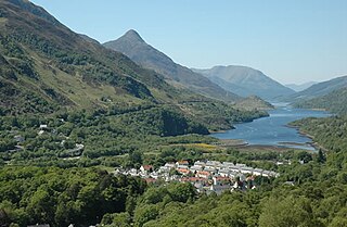
Kinlochleven is a village located in Lochaber, in the Scottish Highlands and lies at the eastern end of Loch Leven. To the north lie the Mamores ridge; to the south lie the mountains flanking Glen Coe.
Charles Scott Meik was an English civil and mechanical engineer, and part of a minor engineering dynasty. His father Thomas Meik was also a civil engineer, as was Charles' brother Patrick Meik; collectively, they established a company which became one of the UK's major engineering consultancies.
Sir William Halcrow was one of the most notable English civil engineers of the 20th century, particularly renowned for his expertise in the design of tunnels and for projects during the Second World War.

Hydroelectricity, or hydroelectric power, is electricity produced from hydropower. In 2015, hydropower generated 16.6% of the world's total electricity and 70% of all renewable electricity, and was expected to increase by about 3.1% each year for the next 25 years.

Kárahnjúkar Hydropower Plant, officially called Fljótsdalur Power Station is a hydroelectric power plant in Fljótsdalshérað municipality in eastern Iceland, designed to produce 4,600 gigawatt-hours (17,000 TJ) annually for Alcoa's Fjarðaál aluminum smelter 75 kilometres (47 mi) to the east in Reyðarfjörður. With the installed capacity of 690 megawatts (930,000 hp), the plant is the largest power plant in Iceland. The project, named after the nearby Kárahnjúkar mountains, involves damming the rivers Jökulsá á Dal and Jökulsá í Fljótsdal with five dams, creating three reservoirs. Water from the reservoirs is diverted through 73 kilometres (45 mi) of underground water tunnels and down a 420-metre (1,380 ft) vertical penstock towards a single underground power station. The smelter became fully operational in 2008 and the hydropower project was completed in 2009.

Loch Thom is a reservoir which since 1827 has provided a water supply to the town of Greenock in Inverclyde, Scotland. It is named after the civil engineer Robert Thom who designed the scheme which created the reservoir and delivered water via a long aqueduct known as The Cut. Today, as well as providing a water supply, the loch is used for sport fishing and forms part of the Clyde Muirshiel Regional Park with several attractive walks and a centre at Cornalees Bridge providing nature study facilities.

The Idukki Dam is a double curvature Arch dam constructed across the Periyar River in a narrow gorge between two granite hills locally known as Kuravan and Kurathi in Mariyapuram village in Idukki District in Kerala, India. At 168.91 metres (554.2 ft), it is one of the highest arch dams in Asia. It is constructed and owned by the Kerala State Electricity Board. It supports a 780 MW hydroelectric power station in Moolamattom, which started generating power on 4 October 1975. The dam type is a concrete, double curvature parabolic, thin arc dam. The Indo-Canadian project was inaugurated by the Prime Minister Indira Gandhi on February 17, 1976.
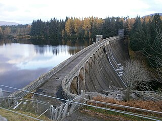
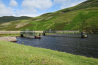
Laggan Dam is a dam located on the River Spean south west of Loch Laggan in the Scottish Highlands.
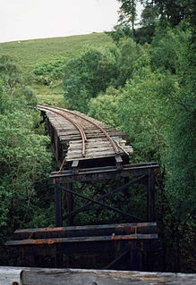
The Lochaber Narrow Gauge Railway was a 3 ft narrow-gauge industrial railway. It was a relatively long line, built for the construction and subsequent maintenance of a 15-mile-long (24-kilometre) tunnel from Loch Treig to a factory near Fort William in Scotland. The tunnel was excavated to carry water for the Lochaber hydroelectric scheme in connection with aluminium production by British Aluminium. The railway came to be known colloquially as the 'Old Puggy Line'.

The Steenbras Dam, now referred to as Steenbras Lower Dam, is a gravity concrete arch type dam located in the Hottentots-Holland mountains, above Gordons Bay, near Cape Town in South Africa. It is one of the six large dams that make up the Western Cape Water Supply System. It is owned by the City of Cape Town and serves principally to supply water to that city. The dam wall is 28 metres (92 ft) high and 412 metres (1,352 ft) long; it impounds a reservoir of 36,133 megalitres over a surface area of 380 hectares when full.

Loch Mhòr is a loch in the traditional county of Inverness-shire in the Scottish Highlands. It occupies much of the wide floor of Stratherrick which runs roughly parallel to Loch Ness, around 3 mi (4.8 km) to its southeast. A generally shallow body of water 179 m (587 ft) above Loch Ness, Loch Mhòr achieves a depth in excess of 20 m (66 ft) towards its southern end.
The Lochaber hydroelectric scheme is a hydroelectric power generation project constructed in the Lochaber area of the western Scottish Highlands after the First World War. Like its predecessor at Kinlochleven, it was intended to provide electricity for aluminium production, this time at Fort William, a little further north. It is still in operation.

Egglfing-Obernberg Hydropower Plant is a run-of-the-river hydroelectric power plant on the Inn, where the river forms the border between Germany and Austria. The municipality of Egglfing, Bavaria is located on the left side of the Inn and the municipality of Obernberg, Upper Austria on the right side.
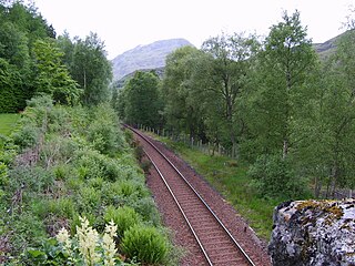
Fersit Halt railway station named after the nearby hamlet of Fersit, was situated close to Tulloch railway station in Lochaber, Highland council area, Scotland. Fersit was a remote rural temporary private halt at the north end of Loch Treig where workers were housed who worked on the Lochaber hydroelectric scheme. The halt was opened in 1931 by the LNER, it was located near the site of a contractors railway ballast siding.
Edinburgh Water Company and its successors have provided a public water supply and latterly sewerage and sewage treatment services to the Scottish Capital of Edinburgh. The original company was established in 1819 to supply drinking water. It did so until 1870, when it was taken over by a public Water Trust, with representatives from Edinburgh, Leith and Portobello. That in turn was taken over by Edinburgh Corporation and in 1975, responsibility passed to the Lothian Regional Council, as did the duty to provide sewerage and sewage treatment services. Both services were moved out of local authority control, and taken over by the East of Scotland Water Authority in 1996. The three Scottish regional water authorities were merged to form Scottish Water in 2002.

Glasgow Corporation Water Works and its successors have provided a public water supply and sewerage and sewage treatment services to the Scottish city of Glasgow. There were several schemes in the early part of the 1800s, with the Glasgow Company which was established in 1806 pumping filtered water from the River Clyde into the city. The Gorbals Gravitation Water Company was established in 1846, and brought water from reservoirs to the south-west of the city. However, an outbreak of cholera in 1848/1849, in which 4,000 people died, concentrated the minds of Glasgow Council, and in 1855 a scheme to use water from Loch Katrine, 36 miles (58 km) to the north, was authorised. The work required at Loch Katrine was quite modest, and the major construction work was the building of an aqueduct to carry the water to the city by gravity.

