Blanchardville, Wisconsin

Last updated

Blanchardville, Wisconsin
Blanchardville.jpg
Aerial view of Blanchardville
Iowa County Wisconsin Incorporated and Unincorporated areas Blanchardville Highlighted.svg
Location of Blanchardville in Iowa County, Wisconsin.
Coordinates: 42°48′37″N89°51′42″W / 42.81028°N 89.86167°W / 42.81028; -89.86167
Country Flag of the United States.svg  United States
State Flag of Wisconsin.svg  Wisconsin
Counties Lafayette, Iowa
Area
[1]
  Total0.48 sq mi (1.25 km2)
  Land0.48 sq mi (1.25 km2)
  Water0.00 sq mi (0.00 km2)
Elevation
[2]
823 ft (251 m)
Population
 (2010) [3]
  Total825
  Estimate 
(2019) [4]
791
  Density1,644.49/sq mi (634.74/km2)
Time zone UTC-6 (Central (CST))
  Summer (DST) UTC-5 (CDT)
Area code 608 608
FIPS code 55-08125 [5]
GNIS feature ID1561917 [2]
Website blanchardville.com

Blanchardville is a village in Iowa and Lafayette counties in the U.S. state of Wisconsin. The population was 825 at the 2010 census. Of this, 648 were in Lafayette County, and 177 were in Iowa County.

Contents

The Iowa County portion of Blanchardville is part of the Madison Metropolitan Statistical Area.

History

The community was originally settled by members of the Church of Jesus Christ of Latter Day Saints (Strangite) in the early 1840s, who named it Zarahemla. [6] [7] The Mormon settlers mined lead ore and farmed. [8] Blanchardville's first mill was built in 1840. [9]

Main Street of Blanchardville on Decoration Day, 1908 Blanchardville, Decoration Day 1908.jpg
Main Street of Blanchardville on Decoration Day, 1908

In 1856, Alvin Blanchard moved to the area from his farm near Dodgeville. He purchased the mill on the Pecatonica river from the Mormons, who mostly left the area. Along with Cyrus Newkirk, he platted the village which currently bears his name in 1857. The village received its first post office the next year. [10] The Yankee settlers established a Methodist church in 1852. A Norwegian Lutheran congregation shared the church from 1864 until 1892 when their own separate church was built. The village's most prominent ethnic group is the Norwegians, [11] as the village is between the large historic Blue Mounds and Wiota Norwegian settlements. Yankee, Irish, Swiss, and German settlers were in the village also and in 1898 the first Catholic church was built. Nearby rural churches in the area included Norwegian Lutheran congregations in York, Yellowstone, and Adams townships, and an Irish Catholic congregation in Yellowstone as well. [12]

The village's main park, McKellar Park, was given to the village in 1930 by the wife of the most prominent village doctor, Dr. Archibald McKellar, after his death. [12] Today the park is host to many activities including an annual car show and Fathers' Day Barbeque. [13] The school district is Pecatonica Area Schools, formed after combining with the neighboring village of Hollandale in 1971. The school mascot is the Viking, in tribute to the strength of a Norwegian Heritage. [14]

Geography

Blanchardville is located on the East Branch Pecatonica River. The community is served by Wisconsin Highway 78 and routes F and H. [15]

According to the United States Census Bureau, the village has a total area of 0.50 square miles (1.29 km2), all of it land. [16]

Demographics

Historical population
CensusPop.Note
1880 169
1900 573
1910 64312.2%
1920 6531.6%
1930 651−0.3%
1940 6621.7%
1950 7076.8%
1960 632−10.6%
1970 79425.6%
1980 8031.1%
1990 802−0.1%
2000 8060.5%
2010 8252.4%
2019 (est.)791 [4] −4.1%
U.S. Decennial Census [17]

2010 census

As of the census [3] of 2010, there were 825 people, 360 households, and 228 families living in the village. The population density was 1,650.0 inhabitants per square mile (637.1/km2). There were 396 housing units at an average density of 792.0 per square mile (305.8/km2). The racial makeup of the village was 98.9% White, 0.1% African American, 0.2% Asian, 0.2% from other races, and 0.5% from two or more races. Hispanic or Latino of any race were 1.2% of the population.

There were 360 households, of which 31.4% had children under the age of 18 living with them, 47.2% were married couples living together, 10.0% had a female householder with no husband present, 6.1% had a male householder with no wife present, and 36.7% were non-families. 31.7% of all households were made up of individuals, and 13.3% had someone living alone who was 65 years of age or older. The average household size was 2.29 and the average family size was 2.86.

The median age in the village was 40.8 years. 24.7% of residents were under the age of 18; 6.9% were between the ages of 18 and 24; 24.7% were from 25 to 44; 28.8% were from 45 to 64; and 14.9% were 65 years of age or older. The gender makeup of the village was 50.4% male and 49.6% female.

2000 census

As of the census [5] of 2000, there were 806 people, 346 households, and 206 families living in the village. The population density was 1,837.4 people per square mile (707.3/km2). There were 376 housing units at an average density of 857.1 per square mile (329.9/km2). The racial makeup of the village was 99.38% White, 0.25% Asian, and 0.37% from two or more races. Hispanic or Latino of any race were 0.37% of the population.

There were 346 households, out of which 28.6% had children under the age of 18 living with them, 50.9% were married couples living together, 7.2% had a female householder with no husband present, and 40.2% were non-families. 35.8% of all households were made up of individuals, and 17.1% had someone living alone who was 65 years of age or older. The average household size was 2.33 and the average family size was 3.05.

In the village, the population was spread out, with 24.9% under the age of 18, 6.7% from 18 to 24, 29.8% from 25 to 44, 20.7% from 45 to 64, and 17.9% who were 65 years of age or older. The median age was 38 years. For every 100 females, there were 98.5 males. For every 100 females age 18 and over, there were 96.4 males.

The median income for a household in the village was $40,313, and the median income for a family was $51,776. Males had a median income of $31,908 versus $26,208 for females. The per capita income for the village was $18,104. About 6.7% of families and 9.8% of the population were below the poverty line, including 9.6% of those under age 18 and 8.3% of those age 65 or over.

Education

Blanchardville is served by the Pecatonica Area Schools, which includes Pecatonica High School, Pecatonica Middle School and Pecatonica Elementary School.

Sports and recreation

Notable people

Related Research Articles

<span class="mw-page-title-main">Lafayette County, Wisconsin</span> County in Wisconsin, United States

Lafayette County, sometimes spelled La Fayette County, is a county located in the U.S. state of Wisconsin. It was part of the Wisconsin Territory at the time of its founding. As of the 2020 census, the population was 16,611. Its county seat is Darlington. The county was named in honor of the Marquis de Lafayette, the French general who rendered assistance to the Continental Army in the American Revolutionary War. The courthouse scenes from the 2009 film Public Enemies were filmed at the Lafayette County Courthouse in Darlington.

<span class="mw-page-title-main">Iowa County, Wisconsin</span> County in Wisconsin, United States

Iowa County is a county in the U.S. state of Wisconsin. As of the 2020 census, the population was 23,709. Its county seat and largest city is Dodgeville. When created, it was part of the Michigan Territory. Iowa County is part of the Madison, Wisconsin, Metropolitan Statistical Area.

<span class="mw-page-title-main">Pecatonica, Illinois</span> Village in Illinois, United States

Pecatonica is a village in Winnebago County, Illinois, United States. It is part of the Rockford, Illinois Metropolitan Statistical Area. The population was 2,195 at the 2010 census, up from 1,997 in 2000.

<span class="mw-page-title-main">DeForest, Wisconsin</span> Village in Wisconsin, United States

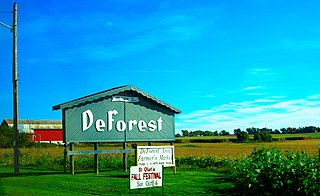
DeForest is a village in Dane County, Wisconsin, United States, along the Yahara River. The population was 10,811 at the 2020 census. It is part of the Madison Metropolitan Statistical Area.

<span class="mw-page-title-main">Jordan, Wisconsin</span> Town in Wisconsin, United States

Jordan is a town in Green County, Wisconsin, United States. The population was 577 at the 2000 census. The unincorporated community of Jordan Center is located in the town.

<span class="mw-page-title-main">York, Green County, Wisconsin</span> Town in Wisconsin, United States

York is a town in Green County, Wisconsin, United States. The population was 910 at the 2010 census. The unincorporated community of Postville is located in the town. The ghost town of Farmers Grove was also located in the town.

<span class="mw-page-title-main">Blanchard, Wisconsin</span> Town in Wisconsin, United States

Blanchard is a town in Lafayette County, Wisconsin, United States. The population was 264 at the 2010 census. The town was founded in the 1840s by a branch of the Church of Jesus Christ of Latter Day Saints led by James Jesse Strang. It was named for Alvin Blanchard, who jointly owned the site along with Cyrus Newkirk.

<span class="mw-page-title-main">Fayette, Wisconsin</span> Town in Wisconsin, United States

Fayette is a town in Lafayette County, Wisconsin, United States. The population was 376 at the 2010 census. The unincorporated communities of Fayette and Yellowstone are located in the town.

<span class="mw-page-title-main">Lamont, Wisconsin</span> Town in Wisconsin, United States

Lamont is a town in Lafayette County, Wisconsin, United States. The population was 314 at the 2010 census, up from 267 at the 2000 census. The unincorporated community of Lamont is located in the town.

<span class="mw-page-title-main">Wayne, Lafayette County, Wisconsin</span> Town in Wisconsin, United States

Wayne is a town in Lafayette County, Wisconsin, United States. The population was 490 at the 2010 census.

<span class="mw-page-title-main">Wiota, Wisconsin</span> Town in Wisconsin, United States

Wiota is a town in Lafayette County, Wisconsin, United States. The population was 856 at the 2010 census. The unincorporated communities of Wiota, Woodford and Five Corners are located in the town.

<span class="mw-page-title-main">Valders, Wisconsin</span> Village in Wisconsin, United States

Valders is a village in Manitowoc County, Wisconsin, United States. The population was 962 at the 2010 census.

Gratiot is a town in Lafayette County, Wisconsin, United States. The population was 550 at the 2010 census, down from 653 at the 2000 census. The village of Gratiot is located within the town. The unincorporated community of Riverside and part of the unincorporated community of Dunbarton are also in the town.

<span class="mw-page-title-main">Oregon, Wisconsin</span> Village in Wisconsin, United States

Oregon is a village in Dane County, Wisconsin. As of the census of 2020, the population was 11,179. Oregon is part of the Madison Metropolitan Statistical Area. The village is located mostly within the Town of Oregon.

Argyle is a town in Lafayette County, Wisconsin, United States. The population was 436 at the 2010 census, down from 479 at the 2000 census. The village of Argyle is located within the town.

<span class="mw-page-title-main">Argyle, Wisconsin</span> Village in Wisconsin, United States

Argyle is a village in Lafayette County, Wisconsin, United States. The population was 857 at the 2010 census, up from 823 at the 2000 census. The village is located within the Town of Argyle.

Darlington is a town in Lafayette County, Wisconsin, United States. The population was 875 at the 2010 census, up from 757 at the 2000 census. The city of Darlington, the Lafayette county seat, is located within the town. The unincorporated settlement of Red Rock is in the east part of the town.

<span class="mw-page-title-main">Darlington, Wisconsin</span> City in Wisconsin, United States

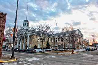
Darlington is a city in and the county seat of Lafayette County in the U.S. state of Wisconsin. The population was 2,462 at the 2020 census. The city is surrounded by the Town of Darlington.

<span class="mw-page-title-main">Spring Green, Wisconsin</span> Village in Wisconsin, United States

Spring Green is a village in Sauk County, Wisconsin, United States. The population was 1,628 at the 2010 census. The village is located within the Town of Spring Green.

<span class="mw-page-title-main">Brooklyn (village), Wisconsin</span> Place in Wisconsin, United States

Brooklyn is a village in Dane and Green counties in Wisconsin, United States. The population was 1,524 at the 2020 census, with 1,026 residents in Dane County and 498 in Green County.

References

  1. "2019 U.S. Gazetteer Files". United States Census Bureau. Retrieved August 7, 2020.
  2. 1 2 U.S. Geological Survey Geographic Names Information System: Blanchardville, Wisconsin
  3. 1 2 "U.S. Census website". United States Census Bureau . Retrieved November 18, 2012.
  4. 1 2 "Population and Housing Unit Estimates". United States Census Bureau. May 24, 2020. Retrieved May 27, 2020.
  5. 1 2 "U.S. Census website". United States Census Bureau . Retrieved January 31, 2008.
  6. "Blanchardville (origin of place name)" from the Dictionary of Wisconsin History , which misspelled Zarahemla as Zarahemia.
  7. "Church of Jesus Christ of Latter Day Saints in Wisconsin" from the Dictionary of Wisconsin History , which mentions the correct spelling of Zarahemla.
  8. "Mormons in Early Wisconsin (Historic Marker Erected 1992)" from the Dictionary of Wisconsin History
  9. "Blanchardville Loses Old Mill Build in '40" The Capital Times , March 9, 1930.
  10. "Blanchard, Alvin 1830 - 1910" from the Dictionary of Wisconsin History
  11. "Ancestry Map of Norwegian Communities". Epodunk.com. Retrieved August 12, 2008.
  12. 1 2 Blanchardville, Welcome Home: 125 Years of History
  13. "Home". Blanchardville Wisconsin.
  14. "Pecatonica Area School District". www.pecatonica.k12.wi.us.
  15. Blanchardville, WI, 7.5 Minute Topographic Quadrangle, USGS, 1962
  16. "US Gazetteer files 2010". United States Census Bureau. Archived from the original on January 25, 2012. Retrieved November 18, 2012.
  17. "Census of Population and Housing". Census.gov. Retrieved June 4, 2015.