Mifflin, Wisconsin

Last updated

Mifflin, Wisconsin
WIMap-doton-Mifflin.png
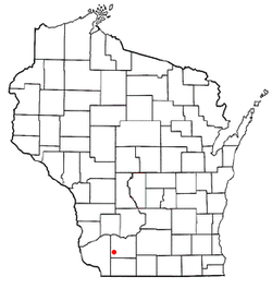
Location of Mifflin, Wisconsin
Coordinates: 42°52′19″N90°21′12″W / 42.87194°N 90.35333°W / 42.87194; -90.35333
Country Flag of the United States.svg  United States
State Flag of Wisconsin.svg  Wisconsin
County Iowa
Area
  Total50.7 sq mi (131.3 km2)
  Land50.7 sq mi (131.3 km2)
  Water0.0 sq mi (0.0 km2)
Elevation
[1]
984 ft (300 m)
Population
 (2000)
  Total617
  Density12.2/sq mi (4.7/km2)
Time zone UTC-6 (Central (CST))
  Summer (DST) UTC-5 (CDT)
Area code 608
FIPS code 55-51725 [2]
GNIS feature ID1583713 [1]

Mifflin is a town in Iowa County, Wisconsin, United States. The population was 617 at the 2000 census. The unincorporated community of Mifflin is located in the town. The extinct community of Dallas was located in the town. [3]

Contents

History

On April 14, 2010, a fireball from outer space streaked across several Midwestern states and landed outside of Mifflin. The highly publicized Mifflin fireball, as it is now known, has produced several pounds of meteorites, and was featured on The Science Channel's Meteorite Men. [4] The meteorite has been studied and classified as a L5 chondrite by scientists at the University of Wisconsin. [5]

Geography

According to the United States Census Bureau, the town has a total area of 50.7 square miles (131.3 km2), all of it land.

Demographics

As of the census [2] of 2000, there were 617 people, 201 households, and 163 families residing in the town. The population density was 12.2 people per square mile (4.7/km2). There were 209 housing units at an average density of 4.1 per square mile (1.6/km2). The racial makeup of the town was 99.51% White, 0.16% African American, and 0.32% from two or more races. Hispanic or Latino of any race were 0.49% of the population.

There were 201 households, out of which 47.8% had children under the age of 18 living with them, 74.1% were married couples living together, 2.5% had a female householder with no husband present, and 18.9% were non-families. 15.9% of all households were made up of individuals, and 10.0% had someone living alone who was 65 years of age or older. The average household size was 3.07 and the average family size was 3.47.

In the town, the population was spread out, with 35.0% under the age of 18, 4.4% from 18 to 24, 28.8% from 25 to 44, 23.5% from 45 to 64, and 8.3% who were 65 years of age or older. The median age was 35 years. For every 100 females, there were 98.4 males. For every 100 females age 18 and over, there were 109.9 males.

The median income for a household in the town was $42,083, and the median income for a family was $46,250. Males had a median income of $23,409 versus $21,806 for females. The per capita income for the town was $15,129. About 5.1% of families and 11.5% of the population were below the poverty line, including 17.7% of those under age 18 and 9.8% of those age 65 or over.

Notable people

Related Research Articles

<span class="mw-page-title-main">Cumberland, Iowa</span> City in Iowa, United States

Cumberland is a city in Cass County, Iowa, United States that was founded in 1884. The population was 251 at the time of the 2020 census. Cumberland's sister community is Massena, Iowa.

<span class="mw-page-title-main">Kensett, Iowa</span> City in Iowa, United States

Kensett is a city in Worth County, Iowa, United States. The population was 257 at the time of the 2020 census. It is part of the Mason City Micropolitan Statistical Area.

<span class="mw-page-title-main">Sherman, Maine</span> Town in the state of Maine, United States

Sherman is a town in Aroostook County, Maine, United States. The population was 815 at the 2020 census.

<span class="mw-page-title-main">Chicora, Pennsylvania</span> Borough in Pennsylvania, United States

Chicora is a borough in Butler County, Pennsylvania, United States. The population was 1,043 at the 2010 census.

<span class="mw-page-title-main">Brownsville Township, Pennsylvania</span> Township in Pennsylvania, United States

Brownsville Township is a township in Fayette County, Pennsylvania, United States. The population was 536 at the 2020 census, a decline from the figure of 683 tabulated in 2010. It is served by the Brownsville School District.

<span class="mw-page-title-main">Cedar Lake, Wisconsin</span> Town in Wisconsin, United States

Cedar Lake is a town in Barron County in the U.S. state of Wisconsin. The population was 1,076 at the 2020 census. The unincorporated communities of Angus and Mikana are located in the town.

<span class="mw-page-title-main">Fall River, Wisconsin</span> Village in Wisconsin, United States

Fall River is a village in Columbia County, Wisconsin, United States, along the North Fork of the Crawfish River. The population was 1,712 at the 2010 census. It is part of the Madison Metropolitan Statistical Area.

<span class="mw-page-title-main">Tiffany, Wisconsin</span> Town in Wisconsin, United States

Tiffany is a town in Dunn County, Wisconsin, United States. The population was 617 at the time of the 2020 census. The villages of Boyceville and Downing are adjacent to the town.

<span class="mw-page-title-main">Brunswick, Wisconsin</span> Town in Wisconsin, United States

Brunswick is a town in Eau Claire County, Wisconsin, United States. The population was 1,624 at the 2010 census. The unincorporated communities of Lufkin and Mount Hope Corners are located in the town.

<span class="mw-page-title-main">Waldwick, Wisconsin</span> Town in Wisconsin, United States

The Town of Waldwick is a town located in Iowa County, Wisconsin, United States. The population was 500 at the 2000 census. The unincorporated communitu of Jonesdale is located in the town.

<span class="mw-page-title-main">Wyoming, Iowa County, Wisconsin</span> Town in Wisconsin, United States

The Town of Wyoming is a town located in Iowa County, Wisconsin, United States. The population was 317 at the 2020 census.

<span class="mw-page-title-main">Rock Elm, Wisconsin</span> Town in Wisconsin, United States

Rock Elm is a town in Pierce County, Wisconsin, United States. The population was 504 at the 2000 census. The unincorporated communities of Exile and Rock Elm are located in the town. The unincorporated community of Waverly is also located partially in the town.

<span class="mw-page-title-main">Springwater, Wisconsin</span> Town in Wisconsin, United States

Springwater is a town in Waushara County, Wisconsin, United States. The population was 1,389 at the 2000 census.

<span class="mw-page-title-main">Livingston, Wisconsin</span> Village in Wisconsin divided between two counties

Livingston is a village in Grant and Iowa Counties in the U.S. state of Wisconsin. The population was 664 at the 2010 census. Of this, 657 were in Grant County, and only 7 were in Iowa County.

<span class="mw-page-title-main">Montfort, Wisconsin</span> Village in Wisconsin, United States

Montfort is a village in Grant and Iowa Counties in the U.S. state of Wisconsin. The population was 718 at the 2010 census. Of this, 622 were in Grant County, and 96 were in Iowa County.

The Town of Arena is a town located in Iowa County, Wisconsin, United States. The population was 1,444 at the 2000 census. The Village of Arena is located within the town. The unincorporated communities of Coon Rock, and Helena are also located within the town.

Highland is a town in Iowa County, Wisconsin, United States. The population was 797 at the 2000 census. The village of Highland is located within the town.

Belmont is a town in Lafayette County, Wisconsin, United States. The population was 767 at the 2010 census, up from 676 at the 2000 census. The village of Belmont is located in the southeastern part of the town. The unincorporated community of Leslie close to the center of the town.

Mosinee is a town in Marathon County, Wisconsin, United States. It is part of the Wausau, Wisconsin Metropolitan Statistical Area. The population was 2,174 at the 2010 census. The unincorporated community of Moon is located partially in the town.

Lost City is an unincorporated community and census-designated place (CDP) in Cherokee County, Oklahoma, United States. The population was 770 at the 2010 census, a 4.8 percent decline from the figure of 809 recorded in 2000. It was the site of the first meteorite fall in the US to be recorded by a camera network.

References

  1. 1 2 "US Board on Geographic Names". United States Geological Survey. October 25, 2007. Retrieved January 31, 2008.
  2. 1 2 "U.S. Census website". United States Census Bureau . Retrieved January 31, 2008.
  3. History of Iowa County, Wisconsin . Chicago: Western Historical Company, 1881, p. 582
  4. "Official Meteorite Men Episode Guide". Meteorite Men. Retrieved January 23, 2023.
  5. Kita et al. (2013 ) "Fall, classification, and exposure history of the Mifflin L5 chondrite". Meteoritics & Planetary Science. doi:10.1111/maps.12077
  6. Ipswich, South Dakota
  7. Mary Ellen Snodgrass. The Settlers of the American West: The Lives of 231 Notable Settlers. Jefferson, North Carolina: McFarland and Company, 2015, pp. 128-130.
  8. History of Iowa County, Wisconsin. Chicago: Western Historical Company. 1881. pp. 927–928.

42°52′16″N90°21′14″W / 42.87111°N 90.35389°W / 42.87111; -90.35389