Balsall Heath is an inner-city area of Birmingham, West Midlands, England. It has a diverse cultural mix of people and is the location of the Balti Triangle.

Birmingham City Council is the local government body responsible for the governance of the City of Birmingham in England, which has been a metropolitan district since 1974. It is the most populated local council area in the United Kingdom with 101 elected councillors representing over one million people, in 69 wards. The council headquarters are at the Council House in the city centre. The council is responsible for running nearly all local services, with the exception of those run by joint boards. The provision of certain services has in recent years been devolved to several council constituencies, which each have a constituency committee made up of councillors from that district. It is part of the West Midlands Combined Authority.

Sutton Coldfield or the Royal Town of Sutton Coldfield, known locally as Sutton, is a town and civil parish in the City of Birmingham, West Midlands, England. The town lies around 8 miles northeast of Birmingham city centre, 9 miles south of Lichfield, 7 miles southwest of Tamworth and 7 miles east of Walsall.
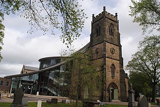
Erdington is a suburb and ward of Birmingham in the West Midlands County, England. Historically part of Warwickshire and located 5 miles (8 km) northeast of central Birmingham, bordering Sutton Coldfield. It was also a council constituency, managed by its own district committee. The former council district consisted of the ward of Erdington, and Tyburn,, Stockland Green and Kingstanding, although all of Kingstanding and most of both Tyburn and Stockland Green wards lie outside the historical boundaries of Erdington. Stockland Green was formerly part of Aston, Kingstanding part of Perry Barr and Tyburn partially split between Aston and Hodge Hill. Erdington (ward) was part of the Sutton Coldfield constituency before 1974.

Boldmere is a suburb and residential area of Sutton Coldfield, City of Birmingham, England. It is bordered by New Oscott, Sutton Park, Wylde Green and Erdington, and is in the ward of Sutton Vesey.
Duddeston is an inner-city area of the Nechells ward of central Birmingham, England. It was part of the Birmingham Duddeston constituency until that ceased to exist in 1950.
Stockland Green is an area of Birmingham, England.

Birmingham Erdington is a parliamentary constituency in Birmingham, England, represented in the House of Commons of the Parliament of the United Kingdom since 2022 by Paulette Hamilton of the Labour Party.

Witton Lakes are a pair of former drinking water reservoirs between the Perry Common and Erdington areas of Birmingham, England.
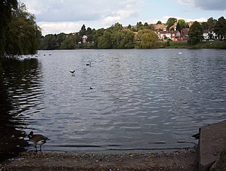
Brookvale Park Lake previously known as Lower Witton Reservoir is a former drinking water reservoir in the Erdington area of Birmingham, England.
Bordesley is an area of Birmingham, England, 1.2 miles (2 km) south east of the city centre straddling the Watery Lane Middleway ring road. It should not be confused with nearby Bordesley Green. Commercial premises dominate to the west of the ring road, but much of this area is to be redeveloped. Blocks of residential apartments are planned and set for completion from the mid-2020s onwards. The largely residential area east of the ring road was renamed Bordesley Village following large scale clearance of back-to-back houses and redevelopment in the 1980s and 90s. Bordesley is the real life setting of the BBC series Peaky Blinders, and home to Birmingham City Football Club's ground, St Andrew's.

The Birmingham Blitz was the heavy bombing by the Nazi German Luftwaffe of the city of Birmingham and surrounding towns in central England, beginning on 9 August 1940 as a fraction of the greater Blitz, which was part of the Battle of Britain; and ending on 23 April 1943. Situated in the Midlands, Birmingham, the most populous British city outside London, was considered an important industrial and manufacturing location. Around 1,852 tons of bombs were dropped on Birmingham, making it the third most heavily bombed city in the United Kingdom in the Second World War, behind London and Liverpool.
This article is intended to show a timeline of events in the History of Birmingham, England, with a particular focus on the events, people or places that are covered in Wikipedia articles.

Birmingham is a city and metropolitan borough in the metropolitan county of West Midlands in England. It is the second-largest city in the United Kingdom with a population of 1.145 million in the city proper, 2.92 million in the West Midlands metropolitan county, and approximately 4.3 million in the wider metropolitan area. It is the largest UK metropolitan area outside of London. Birmingham is commonly referred to as the second city of the United Kingdom.

Bromford, referred to locally as "the Bromford", is an industrial and residential area of Birmingham, situated between Ward End, Alum Rock, Hodge Hill, Washwood Heath, Shard End, Stechford, Castle Bromwich and Tyburn. The industrial area is predominantly situated on the north side of the M6 motorway, including The Bromford Gate industrial park, Fort Shopping Park, and Fort Dunlop, with one industrial site sitting east of the M6 called Bromford Central. The residential area sits adjacent to the East of the M6 comprising two neighbourhoods, Bromford built along Bromford Drive, and The Firs built along Chipperfield Road. The industrial and residential areas have increasingly become two separate distinguishable places, and not recognised locally as joined or one. This is signified by the M6 & River Tame dividing the two areas, poor public transport links between the two areas, and the areas sitting within three different local authority wards, and two parliamentary constituencies (industrial area situated within Birmingham Erdington and residential area situated within Birmingham Hodge Hill.
California is a small suburban area of Birmingham, England. It lies within Bartley Ward and the Birmingham Edgbaston constituency and is located on the edge of Woodgate Valley Country Park.
King Edward VI Balaam Wood Academy is a coeducational secondary school located in the New Frankley area of Birmingham, West Midlands, England.
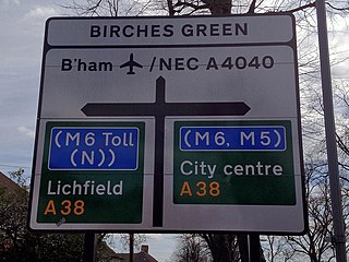
Birches Green is a small area of Tyburn in Birmingham, England, within the parliamentary constitiuency of Erdington. It is located between Gravelly Hill, Erdington and the M6 motorway.

Bordesley Hall was an 18th century manor house near Bordesley, Birmingham, which stood in a 15 hectare park south of the Coventry Road in an area between what is now Small Heath and Sparkbrook. The Georgian house was the successor to an earlier medieval moated manor.
A by-election for the United Kingdom parliamentary constituency of Birmingham Erdington was held on 3 March 2022. It was triggered by the death of the Labour Member of Parliament (MP) Jack Dromey on 7 January. The winner was Paulette Hamilton, standing for Labour, who won 55.5% of the votes on a turnout of 27% of the electorate.


