Blinkwater, KwaZulu-Natal

Last updated
Blinkwater
South Africa KwaZulu-Natal location map.svg
Red pog.svg
Blinkwater
South Africa adm location map.svg
Red pog.svg
Blinkwater
Coordinates: 27°24′18″S30°55′44″E / 27.405°S 30.929°E / -27.405; 30.929 Coordinates: 27°24′18″S30°55′44″E / 27.405°S 30.929°E / -27.405; 30.929
Country South Africa
Province KwaZulu-Natal
District Zululand
Municipality eDumbe
Area
[1]
  Total7.84 km2 (3.03 sq mi)
Population
(2011) [1]
  Total8,810
  Density1,100/km2 (2,900/sq mi)
Racial makeup (2011)
[1]
   Black African 99.6%
   Coloured 0.1%
   Indian/Asian 0.2%
   White 0.1%
First languages (2011)
[1]
   Zulu 96.3%
   S. Ndebele 1.2%
  Other2.5%
Time zone UTC+2 (SAST)
PO box
0931

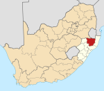
Blinkwater is a town in eDumbe Local Municipality in the KwaZulu-Natal province of South Africa.

eDumbe Local Municipality Local municipality in KwaZulu-Natal, South Africa

eDumbe Local Municipality is an administrative area in the Zululand District of KwaZulu-Natal in South Africa. The municipality is named after the Dumbe mountain.

KwaZulu-Natal Province of South Africa

KwaZulu-Natal is a province of South Africa that was created in 1994 when the Zulu bantustan of KwaZulu and Natal Province were merged. It is located in the southeast of the country, enjoying a long shoreline beside the Indian Ocean and sharing borders with three other provinces and the countries of Mozambique, Eswatini and Lesotho. Its capital is Pietermaritzburg and its largest city is Durban. It is the 2nd most populous province in South Africa, with slightly fewer residents than Gauteng.

South Africa Republic in the southernmost part of Africa

South Africa, officially the Republic of South Africa (RSA), is the southernmost country in Africa. It is bounded to the south by 2,798 kilometres (1,739 mi) of coastline of Southern Africa stretching along the South Atlantic and Indian Oceans; to the north by the neighbouring countries of Namibia, Botswana, and Zimbabwe; and to the east and northeast by Mozambique and Eswatini (Swaziland); and it surrounds the enclaved country of Lesotho. South Africa is the largest country in Southern Africa and the 25th-largest country in the world by land area and, with over 57 million people, is the world's 24th-most populous nation. It is the southernmost country on the mainland of the Old World or the Eastern Hemisphere. About 80 percent of South Africans are of Sub-Saharan African ancestry, divided among a variety of ethnic groups speaking different African languages, nine of which have official status. The remaining population consists of Africa's largest communities of European (White), Asian (Indian), and multiracial (Coloured) ancestry.

Related Research Articles

Table Mountain A flat-topped mountain overlooking the city of Cape Town

Table Mountain is a flat-topped mountain forming a prominent landmark overlooking the city of Cape Town in South Africa. It is a significant tourist attraction, with many visitors using the cableway or hiking to the top. The mountain forms part of the Table Mountain National Park. Table Mountain is home to a large array of fauna and flora, most of which is endemic.

SS <i>Mendi</i> Passenger steamship that sank after a collision south of the Isle of Wight

SSMendi was a British 4,230 GRT passenger steamship that was built in 1905 and, as a troopship, sank after collision with great loss of life in 1917.

Ezemvelo KZN Wildlife is a governmental organisation responsible for maintaining wildlife conservation areas and biodiversity in KwaZulu-Natal Province, South Africa. Their headquarters is in Queen Elizabeth Park situated on the northern slopes of Pietermaritzburg, the KwaZulu-Natal provincial capital. Prior to 1994, it was known as the Natal Parks Board.

Graaff-Reinet Place in Eastern Cape, South Africa

Graaff-Reinet is a town in the Eastern Cape Province of South Africa. It is the fourth-oldest town in South Africa, after Cape Town, Stellenbosch, and Swellendam. The town was the center of a short-lived republic in the late 18th century.

Disa Park

Disa Park is one of the most well-known pieces of architecture in the Vredehoek area of Cape Town, South Africa.

Xhosa Wars series of conflicts

The Xhosa Wars were a series of nine wars or flare-ups between the Xhosa Kingdom and European settlers in what is now the Eastern Cape in South Africa. These events were the longest-running military action in the history of African colonialism.

Mpofu Nature Reserve nature reserve in South Africa

Mpofu Nature Reserve is a nature reserve in the Amatole district of the Eastern Cape Province, South Africa that is managed by Eastern Cape Parks.

Dricky Beukes South African writer

Dricky Beukes was a writer of Afrikaans novels, short stories and radio dramas. Beukes wrote more than a hundred Afrikaans novels, a large number of short stories and numerous Afrikaans radio dramas, including some extensive pieces for the commercial station Springbok Radio. She died in 1999 in Bellville after a battle with blood cancer. There is a Dricky Beukes Street named after her in Kokrus, Vereeniging.

Hlanganani, Limpopo Place in Limpopo, South Africa

Hlanganani, formerly Spelonken, is an amalgamation of various large villages which are situated in the north western portion of the former Tsonga homeland of Gazankulu, South Africa. Hlanganani is situated alongside the R578 road to Giyani and Elim.

Maqoma Xhosa warrior

Maqoma (1798–1873) was a Xhosa warrior. Amongst the greatest of Xhosa military commanders, he played a major part in the Sixth and Eighth Xhosa Wars.

Robert Albert Wessels (Kroonstad, 30 October 1980) is a South African singer and actor.

Eighth Xhosa War

The Eighth Xhosa War was a war between the British Empire and Xhosa as well as Khoikhoi forces, between 1850 and 1853. It was the eighth of nine Xhosa Wars.

References

  1. 1 2 3 4 "Main Place Blinkwater". Census 2011.