KwaZulu-Natal is a province of South Africa that was created in 1994 when the Zulu bantustan of KwaZulu and Natal Province were merged. It is located in the southeast of the country, with a long shoreline on the Indian Ocean and sharing borders with three other provinces and the countries of Mozambique, Eswatini and Lesotho. Its capital is Pietermaritzburg, and its largest city is Durban. It is the second-most populous province in South Africa, with slightly fewer residents than Gauteng.
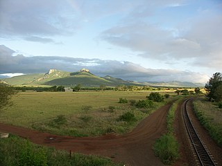
The Lebombo Mountains, also called Lubombo Mountains, are an 800 km-long (500 mi), narrow range of mountains in Southern Africa. They stretch from Hluhluwe in KwaZulu-Natal in the south to Punda Maria in the Limpopo Province in South Africa in the north. Parts of the mountain range are also found in Mozambique and Eswatini.
Ezemvelo KZN Wildlife is a governmental organisation responsible for maintaining wildlife conservation areas and biodiversity in KwaZulu-Natal Province, South Africa. Their headquarters is in Queen Elizabeth Park situated on the northern slopes of Pietermaritzburg, the KwaZulu-Natal provincial capital. Prior to 1994, it was known as the Natal Parks Board.
Utrecht is a town in the foothills of the Balele Mountains, in the northwestern corner of KwaZulu-Natal, South Africa. Newcastle, Kwazulu-Natal's third-largest urban centre, is 50 km from Utrecht. Utrecht has a population of approximately 32,000.
Mkuze, also named Mkhuze or uMkhuze is a small town in Northern KwaZulu-Natal, South Africa. It is located approximately 350 km from the city of Durban. It is along the N2 road en route to Johannesburg, Eswatini and Mozambique; between the Mkuze River and Intaba Yemikhovu. Mkuze is some distance from other small towns such as Hluhluwe (50 km), Nongoma (76 km), Pongola (65 km), and Jozini (25 km). Mkuze is the seat of Umkhanyakude District Municipality.
Westville is an area in KwaZulu-Natal, South Africa, and is just west and inland of Durban. It was a formerly independent town however it became part of the eThekwini Metropolitan Municipality in 2002. Westville is situated 10 km inland from the Durban CBD. The climate is subtropical; Westville experiences mild, dry winters, and hot, humid summers with frequent later afternoon downpours.
Phongolo Nature Reserve is an Ezemvelo KZN Wildlife reserve in Maputaland, KwaZulu-Natal, South Africa. The reserve is 10,485 ha in extent.

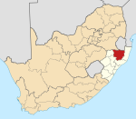
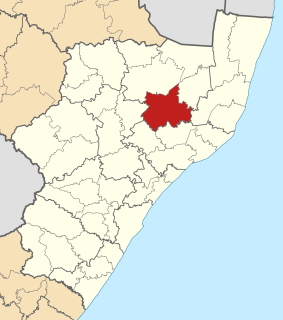
uMkhanyakude is the northernmost of the 11 districts of the KwaZulu-Natal province of South Africa. Its seat is Mkuze. It is a very rural district, the largest town being Mtubatuba in the south, with Hluhluwe, Mkuze, Jozini, Kwangwanase and Ingwavuma further to the north. The majority of its 573,353 people speak IsiZulu. The district code is DC27.

The Colony of Natal was a British colony in south-eastern Africa. It was proclaimed a British colony on 4 May 1843 after the British government had annexed the Boer Republic of Natalia, and on 31 May 1910 combined with three other colonies to form the Union of South Africa, as one of its provinces. It is now the KwaZulu-Natal province of South Africa.
South African number plates are unique in each of the provinces. Each province has their own number plate design and colours, as well as numbering scheme. e.g. NN 22346

AbaQulusi Local Municipality is a local municipality in Zululand in the KwaZulu-Natal province of South Africa. It is named after the AbaQulusi, a Zulu clan whose descendants live in the vicinities of Vryheid, Utrecht, eDumbe and eNgoje. They hailed from different origins but were unified by their allegiance to local Zulu royal homesteads. Historically they were not drafted into ordinary "amabutho" regiments but rather into a royal section, and no "umnumzane" chief presented them in the Zulu king's council.
Ulundi Local Municipality is a local municipality located on the southern boundary of the Zululand District Municipality in northeastern KwaZulu-Natal, South Africa. It is a mainly rural municipality that encompasses the town of Ulundi.

uPhongolo Local Municipality, is a local municipality in the northern area of Zululand, in the South African province of KwaZulu-Natal.

The Zulu Kingdom, sometimes referred to as the Zulu Empire or the Kingdom of Zululand, was a monarchy in Southern Africa that extended along the coast of the Indian Ocean from the Tugela River in the south to Pongola River in the north.
Golela is a border town in Kwa-Zulu Natal Province, South Africa, 45 km east of Pongola on the border with Eswatini. The Golela border post was recently rebuilt to meet the increasing movement of people and goods between South Africa and Eswatini.
Nsubane Pongola Transfrontier Conservation Area is a proposed protected area concept, that could potentially become a joint venture between South Africa and Eswatini. The concept includes the following properties:
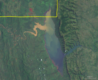
Pongolapoort Dam, commonly referred to as Jozini Dam creating Lake Jozini, is an arch type dam in northern KwaZulu-Natal, South Africa located on the Phongolo River. The dam is situated just north of the settlement of Jozini, 280 km north-east of the port city of Durban. The dam was constructed in 1973 at the eastern end of the narrow gorge separating the Lebombo and Ubombo ranges. The dam mainly serves for irrigation purposes and its hazard potential has been ranked high (3). The Phongolo River is the dam's largest feeder and outlet as well as the dam's only perennial feeder.

The Bivane River, a right bank tributary of the Pongola River, is situated in northern KwaZulu-Natal, South Africa.

The Ngwavuma is a river in Eswatini and KwaZulu-Natal Province in southern Africa. It is also known as the Inguavuma, Ingwavuma, Ingwovuma, and Nggwavuma, and is one of the five major rivers in Eswatini. It arises in southwestern Eswatini and flows eastward. It is a tributary of the Pongola River.