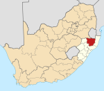
KwaZulu-Natal is a province of South Africa that was created in 1994 when the government merged the Zulu bantustan of KwaZulu and Natal Province.
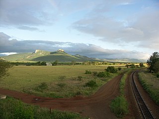
The Lebombo Mountains, also called Lubombo Mountains, are an 800 km-long (500 mi), narrow range of mountains in Southern Africa. They stretch from Hluhluwe in KwaZulu-Natal in the south to Punda Maria in the Limpopo Province in South Africa in the north. Parts of the mountain range are also found in Mozambique and Eswatini.
Pongola is a town on the north bank of the uPhongolo River, in a fertile valley on the N2, near the Lubombo Mountains, in the valleys of Zululand, easily accessible to the Swaziland border posts. It was part of the Transvaal panhandle between the Phongolo (Natal) and Swaziland until 1994, when it was transferred to KwaZulu-Natal.
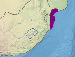
The Maputaland coastal forest mosaic is a subtropical moist broadleaf forest ecoregion on the Indian Ocean coast of Southern Africa. It covers an area of 29,961 square kilometres (11,568 sq mi) in southern Mozambique, Eswatini, and the KwaZulu-Natal Province of South Africa. Mozambique's capital Maputo lies within the ecoregion.

The uMkhanyakude District Municipality is the northernmost of the 11 districts of the KwaZulu-Natal province of South Africa. Its seat is Mkuze. It is a very rural district, the largest town being Mtubatuba in the south, with Hluhluwe, Mkuze, Jozini, Kwangwanase and Ingwavuma further to the north. The majority of its 573,353 inhabitants spoke isiZulu as of 2001. The district code is DC27.

Vulamehlo Local Municipality was a local municipality in Ugu District Municipality, KwaZulu-Natal. It was located south of the eThekwini municipality and bordered by uMdoni to the east, Mkhambathini and Richmond to the north and Ubuhlebezwe to the west. There is an almost equal split of land between commercial agriculture and traditional settlement areas. 48% of the area is held under communal ownership through traditional authorities; the balance of the area is privately owned, except for Vernon Crookes Nature Reserve, which is managed by Ezemvelo KZN Wildlife. In 2016 the municipality was divided between eThekwini and uMdoni.

The Phongolo River is a river in South Africa. It is a tributary of the Maputo River. It rises near Utrecht in northern KwaZulu-Natal, flows east through oPhongolo, is dammed at Pongolapoort, and crosses the Ubombo Mountains; then it flows north towards Mozambique, joining the Maputo River.
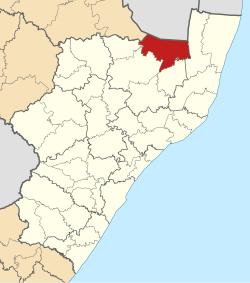
Abaqulusi Municipality is a local municipality within Zululand District Municipality, in the KwaZulu-Natal province of South Africa. It is named after the abaQulusi, a Zulu clan whose descendants live in the vicinities of Vryheid, Utrecht, Paulpietersburg and Louwsburg. They hailed from different origins but were unified by their allegiance to local Zulu royal homesteads.

Nongoma Municipality is a local municipality within the northeastern part of the Zululand District Municipality, in the KwaZulu-Natal province of South Africa. It is Zululand's second largest municipality in terms of population and the second largest in terms of area. It shares its name with the town of Nongoma, which serves as the seat of the municipality.

Ulundi Municipality is a local municipality within the southern part of the Zululand District Municipality, in the KwaZulu-Natal province of South Africa. It is a mainly rural municipality, and its seat is Ulundi.
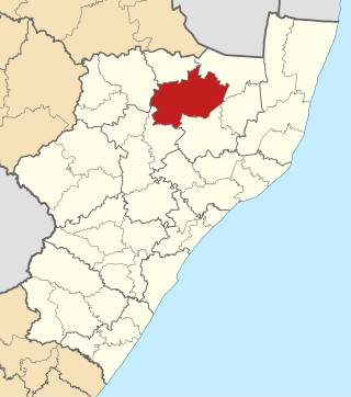
uMhlabuyalingana Municipality is a local municipality within the uMkhanyakude District Municipality, in the northeastern part of the KwaZulu-Natal province of South Africa. The municipality is one of the poorest in the country. It encompasses a World Heritage Site and several areas under environmental protection. Areas of conservation and environmental interest within or adjacent to the uMhlabuyalingana area include the Tembe Elephant Park, iSimangaliso Wetland Park, the Suni-Ridge Sand Forest Park, and the Phongolo Nature Reserve.
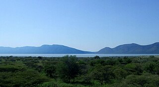
Pongolapoort Dam, commonly referred to as Jozini Dam creating Lake Jozini, is an arch type dam in northern KwaZulu-Natal, South Africa located on the Phongolo River. The dam is situated just north of the settlement of Jozini, 280 km north-east of the port city of Durban. The dam was constructed in 1973 at the eastern end of the narrow gorge separating the Lebombo and Ubombo ranges. The dam mainly serves for irrigation purposes and its hazard potential has been ranked high (3). The Phongolo River is the dam's largest feeder and outlet as well as the dam's only perennial feeder.

Matatiele Municipality is a local municipality within the Alfred Nzo District Municipality, in the Eastern Cape province of South Africa. It adjoins Lesotho to the north, Elundini to the south-west, and Greater Kokstad to the east and its 4,352 km² makes the Matatiele Municipality largest of four municipalities in the district at almost half of its geographical area. According to the South African National Census of 2011, its 203,483 residents and 49,527 households makes Matatiele Municipality the second largest populated area in the Alfred Nzo District Municipality behind Mbizana.

Maphumulo Local Municipality is an administrative area in the iLembe District of KwaZulu-Natal in South Africa. Maphumulo is an isiZulu name meaning "place of rest".

Umzimkhulu Municipality is a local municipality within the Harry Gwala District Municipality, in the KwaZulu-Natal province of South Africa. Umzimkhulu is an isiXhosa and isiZulu word meaning "big/great house". Prior to the Twelfth Amendment of the Constitution of South Africa in 2005, confirmed by the Thirteenth in 2007, it was part of the Eastern Cape.

Umzumbe Municipality is a local municipality within the Ugu District Municipality, in the KwaZulu-Natal province of South Africa. The municipality is named after the Umzumbe River. Towns within the municipal boundaries include Friedenau, KwaDweshula, St Faith’s, and Umzumbe.

UMshwathi Local Municipality is situated in UMgungundlovu District Municipality (UMDM) which is in the foothills of the province of KwaZulu-Natal, about 120 km northwest of Durban, geographically located between the N2 and the N3 highways. The municipality is the largest Municipality in the largest district of KZN out of the seven Local Municipalities which form UMDM.

uMfolozi Local Municipality is a local municipality within the King Cetshwayo District Municipality of KwaZulu-Natal in South Africa. It is situated around the town of KwaMbonambi, to the north of Richard's Bay, stretching from the Indian Ocean to the edge of the Hluhluwe–Imfolozi Park.

Mkhambathini Municipality is a local municipality within the Umgungundlovu District Municipality, in the KwaZulu-Natal province of South Africa. Mkhabathini is an isiZulu word derived from eMkhambathini meaning "the place of acacia trees".

Big Five Hlabisa Municipality is a local municipality within the uMkhanyakude District Municipality, in the KwaZulu-Natal province of South Africa. It was established for the August 2016 local elections by merging The Big 5 False Bay and Hlabisa local municipalities.