KwaDukuza Local Municipality is one of four municipalities under iLembe District Municipality, KwaZulu-Natal, South Africa. As of 2022 it has a population of 324,912.

Endumeni Municipality is a local municipality within the Umzinyathi District Municipality, in the KwaZulu-Natal province of South Africa. Endumeni is an isiZulu word meaning "a place of thunderstorm". The municipality shares its name with the Endumeni hill.

Maphumulo Local Municipality is an administrative area in the iLembe District of KwaZulu-Natal in South Africa. Maphumulo is an isiZulu name meaning "place of rest".

eMadlangeni Municipality, previously known as Utrecht Municipality, is a local municipality within the Amajuba District Municipality, in the KwaZulu-Natal province of South Africa.

uMdoni Municipality is a local municipality within the Ugu District Municipality, in the KwaZulu-Natal province of South Africa. uMdoni is the isiZulu name for the indigenous forest waterberry plant.

Dannhauser Municipality is a local municipality within the Amajuba District Municipality, in the KwaZulu-Natal province of South Africa. The municipality is named after Renier Dannhauser, a German settler who in 1872 purchased four farms in the area from the Natal Government. The major economic sectors are agriculture and mining. Mining, however, is undergoing a movement away from large scale operations to smaller operations.

Umzimkhulu Municipality is a local municipality within the Harry Gwala District Municipality, in the KwaZulu-Natal province of South Africa. Umzimkhulu is an isiXhosa and isiZulu word meaning "big/great house". Prior to the Twelfth Amendment of the Constitution of South Africa in 2005, confirmed by the Thirteenth in 2007, it was part of the Eastern Cape.

Msinga Municipality is a local municipality within the Umzinyathi District Municipality, in the KwaZulu-Natal province of South Africa. Msinga is an isiZulu word meaning "a current in the sea where air movement causes ripples on top of the water surface and ends up influencing the nearby climatic conditions through its breeze". The municipality is largely located in deep gorges of the Tugela and Buffalo rivers, isolated from the immediate surrounding municipal areas. The population dynamics result in a growing rural area and a declining urban area in the municipality, contrary to most other areas in the country. This can be attributed to the fact that the urban areas of municipality are very small and are unable to provide the normal range of goods and services provided in urban areas.

Mtubatuba Municipality is a local municipality within the Umkhanyakude District Municipality, in the KwaZulu-Natal province of South Africa.

Jozini Municipality is a local municipality within the Umkhanyakude District Municipality, in the KwaZulu-Natal province of South Africa. Significant portions of the municipality have been neglected in terms of economic development. There is a great disparity between the level of service and infrastructure provision between settlement nodes, such as the towns of Mkuze and Jozini, and the surrounding rural areas. Most of the rural area is associated with a lack of development, poverty and poor service provision.

eDumbe Municipality is a local municipality within the Zululand District Municipality, in the KwaZulu-Natal province of South Africa. The municipality is named after the Dumbe mountain.

uMlalazi Local Municipality is an administrative area in the King Cetshwayo District of KwaZulu-Natal in South Africa. The municipality is named after the uMlalazi River.

uMuziwabantu Municipality is a local municipality within the Ugu District Municipality, in the KwaZulu-Natal province of South Africa. uMuziwabantu is an isiZulu word meaning "the people's home", or "a home with wide open doors where everyone is welcome". The main source of income for the area is derived from the municipality's extensive wattle, gum, pine and poplar plantations, and associated industries, including saw mills and furniture-making factories.

Impendle Municipality is a local municipality wirhin the Umgungundlovu District Municipality, in the KwaZulu-Natal province of South Africa. During the 18th century, the Griquas ("Abatwas") used to hide in the mountain in the area because they were accused of stealing livestock from the farmers who decided to fight the Griquas in order to protect their livestock. The Griquas used war spears, and this conflict was called "an outside war", i.e. impiyasendle or impiendle.

Mthonjaneni is an administrative area in the King Cetshwayo District of KwaZulu-Natal in South Africa.
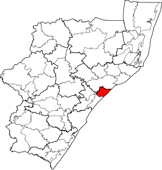
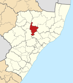
Mandeni Local Municipality is an administrative area in the iLembe District of KwaZulu-Natal in South Africa.

Ndwedwe Local Municipality is an administrative area in the iLembe District of KwaZulu-Natal in South Africa.

uMfolozi Local Municipality is a local municipality within the King Cetshwayo District Municipality of KwaZulu-Natal in South Africa. It is situated around the town of KwaMbonambi, to the north of Richard's Bay, stretching from the Indian Ocean to the edge of the Hluhluwe–Imfolozi Park.

Umvoti Municipality is a local municipality within the Umzinyathi District Municipality, in the KwaZulu-Natal province of South Africa.
The Nquthu Local Municipality council consists of thirty-seven members elected by mixed-member proportional representation. Nineteen councillors are elected by first-past-the-post voting in nineteen wards, while the remaining eighteen are chosen from party lists so that the total number of party representatives is proportional to the number of votes received.