Vulamehlo Local Municipality

Last updated
Vulamehlo
Vulamehlo CoA.png
Map of KwaZulu-Natal with Vulamehlo highlighted.svg
Location of Vulamehlo Local Municipality within KwaZulu-Natal
Coordinates: 30°13′S30°36′E / 30.217°S 30.600°E / -30.217; 30.600 Coordinates: 30°13′S30°36′E / 30.217°S 30.600°E / -30.217; 30.600
Country South Africa
Province KwaZulu-Natal
District Ugu
Seat Scottburgh
Wards 10
Government
[1]
  Type Municipal council
  MayorW.T. Dube
Area
  Total960 km2 (370 sq mi)
Population
 (2011) [2]
  Total77,403
  Density81/km2 (210/sq mi)
Racial makeup (2011)
[2]
   Black African 98.9%
   Coloured 0.2%
   Indian/Asian 0.5%
   White 0.3%
First languages (2011)
[2]
   Zulu 94.6%
   English 1.7%
   Southern Ndebele 1.3%
  Other2.4%
Time zone UTC+2 (SAST)
Municipal codeKZN211

Vulamehlo Local Municipality was a local municipality in Ugu District Municipality, KwaZulu-Natal. It was located south of the eThekwini municipality and bordered by uMdoni to the east, Mkhambathini and Richmond to the north and Ubuhlebezwe to the west. There is an almost equal split of land between commercial agriculture and traditional settlement areas. 48% of the area is held under communal ownership through traditional authorities; the balance of the area is privately owned, except for Vernon Crookes Nature Reserve, which is managed by Ezemvelo KZN Wildlife. [3] In 2016 the municipality was divided between eThekwini and uMdoni.

Contents

Topography

The municipality was characterised by sharp valleys, river systems, and hilly, broken terrain. Approximately 30% of the area was estimated to contain slopes of 1:3 and steeper. The fragmented and steep topography had limited development and agricultural production, and had greatly contributed to the dispersed nature of the area's settlement patterns. [3]

The major river systems within the area were the uMkhomazi, Mpambanyoni and Mthwalume rivers. The other perennial rivers which flow through Vulamehlo included the Nungwane River, Lovu River, Msimbazi River, Mzimayi River, uMzinto and Mkhumbane rivers.

Economy and infrastructure

The Vulamehlo Municipality was largely made up of traditional settlements and was characterised by limited economic activity. The area has high levels of unemployment, with many of those who are employed commuting long distances to other economic centres such as Durban, Port Shepstone, Ixopo, Pietermaritzburg and Johannesburg.

The main sources of income and economic activities in the municipality include subsistence farming and commercial agriculture, including the production of sugarcane and timber plantation. Small-scale sugarcane growers tend to cluster around Dududu, Kenterton and Mfume.

The dispersed, low-density settlement pattern has made the provision of physical and social infrastructure (roads, water, electricity, clinics, schools, and police stations) relatively difficult and expensive. The network of roads connecting the area's settlements is generally poor. The area of former Vulamehlo Municipality is one of the localities within the Ugu District that is hardest hit by high unemployment levels, poverty, and negative economic growth rate. [4]

Main places

The 2001 census divided the municipality into the following main places: [5]

PlaceCodeArea (km2)Population
Cele 50101 22.434,682
Emandleni 50102 60.8310,606
Ezembeni 50103 86.4613,462
Isimahla 50104 66.405,291
Izimpethu Endlovu 50105 14.781,104
Izimpethu Zendlovu & EM 50106 15.975,619
Mapumulo 50107 44.866,200
Mbhele 50108 49.523,725
Nyuswa 50109 16.961,892
Qiko 50110 49.163,074
Thoyana 50111 104.8714,637
Ukuthula 50112 8.112,090
Umzinto 50113 36.066,397
Remainder of the municipality 50114 395.504,272

Politics

The municipal council consisted of twenty members elected by mixed-member proportional representation. Ten councillors were elected by first-past-the-post voting in ten wards, while the remaining ten were chosen from party lists so that the total number of party representatives was proportional to the number of votes received. In the election of 18 May 2011 the African National Congress (ANC) won a majority of thirteen seats on the council. The following table shows the results of the election. [6] [7]

PartyVotesSeats
WardListTotal %WardListTotal
ANC 15,28115,61430,89563.69413
NFP 6,3256,03912,36425.4145
IFP 2,4882,4634,95110.2022
ACDP 1952023970.8000
Total24,28924,31848,607100.0101020
Spoilt votes5105151,025

Related Research Articles

KwaZulu-Natal Province of South Africa

KwaZulu-Natal is a province of South Africa that was created in 1994 when the Zulu bantustan of KwaZulu and Natal Province were merged. It is located in the southeast of the country, with a long shoreline on the Indian Ocean and sharing borders with three other provinces and the countries of Mozambique, Eswatini and Lesotho. Its capital is Pietermaritzburg, and its largest city is Durban. It is the second-most populous province in South Africa, with slightly fewer residents than Gauteng.

Harding, KwaZulu-Natal Place in KwaZulu-Natal, South Africa

Harding is a town situated in the Mzimkulwana River valley, Ugu District Municipality of KwaZulu-Natal, South Africa

Umgungundlovu District Municipality District municipality in KwaZulu-Natal, South Africa

uMgungundlovu is one of the 11 district municipalities ("districts") of KwaZulu-Natal province. The seat of uMgungundlovu is Pietermaritzburg. The majority of its 1 million+ residents speak Zulu. The district code is DC22

Ugu District Municipality District municipality in KwaZulu-Natal, South Africa

Ugu is one of the 11 districts of KwaZulu-Natal province of South Africa. Ugu is Zulu for "coast". It governs the KZN South Coast and its seat is Port Shepstone. The majority of its 722,484 people speak IsiZulu. The district code is DC21.

Hibiscus Coast Local Municipality Former local municipality in KwaZulu-Natal, South Africa

Hibiscus Coast Local Municipality was a local municipality in the province of KwaZulu-Natal in South Africa. It governed the Hibiscus Coast on the KwaZulu-Natal South Coast which attracts tourists from the province and other provinces as well as international tourists.

Abaqulusi Local Municipality Local municipality in KwaZulu-Natal, South Africa

AbaQulusi Local Municipality is a local municipality in Zululand in the KwaZulu-Natal province of South Africa. It is named after the AbaQulusi, a Zulu clan whose descendants live in the vicinities of Vryheid, Utrecht, eDumbe and eNgoje. They hailed from different origins but were unified by their allegiance to local Zulu royal homesteads. Historically they were not drafted into ordinary "amabutho" regiments but rather into a royal section, and no "umnumzane" chief presented them in the Zulu king's council.

uPhongolo Local Municipality Local municipality in KwaZulu-Natal, South Africa

uPhongolo Local Municipality, is a local municipality in the northern area of Zululand, in the South African province of KwaZulu-Natal.

Matatiele Local Municipality Local municipality in Eastern Cape, South Africa

Matatiele Local Municipality is a Category B municipality located in the Alfred Nzo District of Eastern Cape in South Africa. It adjoins Lesotho to the north, Elundini to the south-west, and Greater Kokstad to the east and its 4,352 km² makes the Matatiele Local Municipality largest of four municipalities in the district at almost half of its geographical area. [1]

Indaka Local Municipality Local municipality in KwaZulu-Natal, South Africa

Indaka Local Municipality was an administrative area in the Uthukela District of KwaZulu-Natal in South Africa. The municipality is named after the Indaka River that runs through the municipal area.

Maphumulo Local Municipality Local municipality in KwaZulu-Natal, South Africa

Maphumulo Local Municipality is an administrative area in the iLembe District of KwaZulu-Natal in South Africa. Maphumulo is an isiZulu name meaning "place of rest".

uMdoni Local Municipality Local municipality in KwaZulu-Natal, South Africa

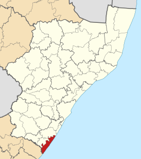
uMdoni Local Municipality is an administrative area in the Ugu District of KwaZulu-Natal in South Africa. Umdoni is an isiZulu name for the indigenous tree, Mdoni.

eDumbe Local Municipality Local municipality in KwaZulu-Natal, South Africa

eDumbe Local Municipality is an administrative area in the Zululand District of KwaZulu-Natal in South Africa. The municipality is named after the Dumbe mountain.

Hlabisa Local Municipality Local municipality in KwaZulu-Natal, South Africa

Hlabisa was an administrative area in the Umkhanyakude District of KwaZulu-Natal in South Africa. Hlabisa is an isiZulu surname of the two nkosis (kings) in the area. The municipality was situated within the vicinity of four Tribal Authorities which are the Mkhwanazi Tribal Authority, the Mdletshe Tribal Authority, and two Hlabisa Tribal Authorities.

uMuziwabantu Local Municipality Local municipality in KwaZulu-Natal, South Africa

uMuziwabantu Local Municipality is an administrative area in the Ugu District of KwaZulu-Natal in South Africa.

Umzumbe Local Municipality Local municipality in KwaZulu-Natal, South Africa

Umzumbe Local Municipality is an administrative area in the Ugu District of KwaZulu-Natal in South Africa.

uMfolozi Local Municipality Local municipality in KwaZulu-Natal, South Africa

uMfolozi Local Municipality is a local municipality within the King Cetshwayo District Municipality of KwaZulu-Natal in South Africa. It is situated around the town of KwaMbonambi, to the north of Richard's Bay, stretching from the Indian Ocean to the edge of the Hluhluwe–Imfolozi Park.

Umvoti Local Municipality Local municipality in KwaZulu-Natal, South Africa

Umvoti Local Municipality is an administrative area in the Umzinyathi District of KwaZulu-Natal in South Africa.

eThekwini Metropolitan Municipality Metropolitan municipality in KwaZulu-Natal, South Africa

eThekwini Metropolitan Municipality is a metropolitan municipality created in 2000, that includes the city of Durban, South Africa and surrounding towns. eThekwini is one of the 11 districts of KwaZulu-Natal province of South Africa. The majority of its 3,442,361 people speak Zulu. It was formed from seven formerly independent local councils and tribal land.

Dududu Place in KwaZulu-Natal, South Africa

Dududu is a small rural area in the South Coast of the KwaZulu-Natal province of South Africa. It is also referred to as Zembeni by locals. The area is primarily used for agriculture, i.e. the sugarcane plantations by the Illovo Sugar company.

The Vulamehlo Local Municipality council consisted of twenty members elected by mixed-member proportional representation. Ten councillors were elected by first-past-the-post voting in ten wards, while the remaining ten were chosen from party lists so that the total number of party representatives was proportional to the number of votes received. In the election of 18 May 2011 the African National Congress (ANC) won a majority of thirteen seats on the council.

References

  1. "Contact list: Executive Mayors". Government Communication & Information System. Archived from the original on 14 July 2010. Retrieved 22 February 2012.
  2. 1 2 3 "Statistics by place". Statistics South Africa. Retrieved 27 September 2015.
  3. 1 2 Vulamehlo Integrated Development Plan (2009/2010 Final Review). Vulamehlo Municipality. Retrieved on Oct 7, 2009.
  4. "Vulamehlo Municipality." Archived 2009-08-21 at the Wayback Machine KwaZulu-Natal Top Business. Retrieved on Oct 7, 2009.
  5. Lookup Tables - Statistics South Africa [ permanent dead link ]
  6. "Results Summary – All Ballots: Vulamehlo" (PDF). Independent Electoral Commission. Retrieved 3 December 2013.
  7. "Seat Calculation Detail: Vulamehlo" (PDF). Independent Electoral Commission. Retrieved 3 December 2013.