Ndwedwe Local Municipality

Last updated
Ndwedwe
Ndwedwe CoA.png
Seal
Map of KwaZulu-Natal with Ndwedwe highlighted.svg
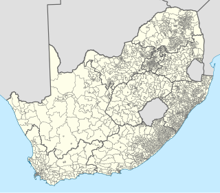
Location in KwaZulu-Natal
Country South Africa
Province KwaZulu-Natal
District iLembe
Seat Ndwedwe
Wards 19
Government
[1]
  Type Municipal council
  MayorWelile Kubheka
Area
  Total1,093 km2 (422 sq mi)
Population
 (2011) [2]
  Total140,820
  Density130/km2 (330/sq mi)
Racial makeup (2011)
[2]
   Black African 98.4%
   Coloured 0.2%
   Indian/Asian 0.7%
   White 0.3%
First languages (2011)
[3]
   Zulu 92.0%
   English 2.0%
   Xhosa 1.9%
   Southern Ndebele 1.5%
  Other2.6%
Time zone UTC+2 (SAST)
Municipal codeKZN293

Ndwedwe Local Municipality is an administrative area in the iLembe District of KwaZulu-Natal in South Africa.

iLembe District Municipality District municipality in KwaZulu-Natal, South Africa

iLembe is one of the 11 district municipalities ("districts") of KwaZulu-Natal province in South Africa. The seat of iLembe is KwaDukuza. The majority (82%) of its 606,809 people speak Zulu. The district code is DC29. It was formerly named the King Shaka District Municipality.

KwaZulu-Natal Province of South Africa

KwaZulu-Natal is a province of South Africa that was created in 1994 when the Zulu bantustan of KwaZulu and Natal Province were merged. It is located in the southeast of the country, enjoying a long shoreline beside the Indian Ocean and sharing borders with three other provinces and the countries of Mozambique, Eswatini and Lesotho. Its capital is Pietermaritzburg and its largest city is Durban. It is the 2nd most populous province in South Africa, with slightly fewer residents than Gauteng.

South Africa Republic in the southernmost part of Africa

South Africa, officially the Republic of South Africa (RSA), is the southernmost country in Africa. It is bounded to the south by 2,798 kilometres (1,739 mi) of coastline of Southern Africa stretching along the South Atlantic and Indian Oceans; to the north by the neighbouring countries of Namibia, Botswana, and Zimbabwe; and to the east and northeast by Mozambique and Eswatini (Swaziland); and it surrounds the enclaved country of Lesotho. South Africa is the largest country in Southern Africa and the 25th-largest country in the world by land area and, with over 57 million people, is the world's 24th-most populous nation. It is the southernmost country on the mainland of the Old World or the Eastern Hemisphere. About 80 percent of South Africans are of Bantu ancestry, divided among a variety of ethnic groups speaking different African languages, nine of which have official status. The remaining population consists of Africa's largest communities of European, Asian (Indian), and multiracial (Coloured) ancestry.

Contents

Primary kaolin deposits occur in Ndwedwe. Good quality material is found near Coqweni, Nozandla and Appelsbosch. [4]

Towns in the municipality include Ndwedwe, Glendale Heights. [5]

Ndwedwe Place in KwaZulu-Natal, South Africa

Ndwedwe is a town in Ilembe District Municipality in the KwaZulu-Natal province of South Africa.

Glendale Heights, South Africa Place in KwaZulu-Natal, South Africa

Glendale Heights is a town in Ilembe District Municipality in the KwaZulu-Natal province of South Africa.

Main places

The 2001 census divided the municipality into the following main places: [6]

South African National Census of 2001

The National Census of 2001 was the 2nd comprehensive national census of the Republic of South Africa, or Post-Apartheid South Africa. It undertook to enumerate every person present in South Africa on the census night between 9–10 October 2001 at a cost of R987,000,000.

PlaceCodeArea (km2)Population
Amalanga 54501 58.576,076
Chili 54502 12.132,124
Cibane 54503 4.49492
Gcwensa 54504 54.9910,982
Hlophe 54505 7.941,462
Inkumba/KwaNyuswa 54506 158.7025,234
Iqadi 54507 48.857,973
Khumalo 54508 12.401,660
Luthuli 54509 24.974,415
Mangangeni/Vumazonke 54510 13.732,068
Mathonsi 54511 40.53547
Mlamuli Nyuswa 54512 127.6621,740
Ndwedwe 54513 193.489,964
Ngcolosi 54514 17.152,459
Ngongoma/Mavela 54515 43.6811,643
Nhlangwini 54516 60.397,785
Nodunga 54517 45.273,015
Nyuswa/Nodwengu 54518 74.4711,577
Qadi 54519 18.753,161
Qwabe (Madundube) 54520 23.062,677
Qwabe N 54521 8.903,545
Shangase 54522 54.627,795
Wosiyane 54523 51.624,114

Politics

The municipal council consists of thirty-seven members elected by mixed-member proportional representation. Nineteen councillors are elected by first-past-the-post voting in nineteen wards, while the remaining eighteen are chosen from party lists so that the total number of party representatives is proportional to the number of votes received. In the election of 3 August 2016 the African National Congress (ANC) won a majority of twenty-seven seats on the council.

Mixed-member proportional (MMP) representation is a mixed electoral system in which voters get two votes: one to decide the representative for their single-seat constituency, and one for a political party. Seats in the legislature are filled firstly by the successful constituency candidates, and secondly, by party candidates based on the percentage of nationwide or region-wide votes that each party received. The constituency representatives are elected using first-past-the-post voting (FPTP) or another plurality/majoritarian system. The nationwide or region-wide party representatives are, in most jurisdictions, drawn from published party lists, similar to party-list proportional representation. To gain a nationwide representative, parties may be required to achieve a minimum number of constituency candidates, a minimum percentage of the nationwide party vote, or both.

First-past-the-post voting voting system in which voters select one candidate, and the candidate who receives more votes than any other candidate wins

A first-past-the-post electoral system is one in which voters indicate on a ballot the candidate of their choice, and the candidate who receives the most votes wins. This is sometimes described as winner takes all. First-past-the-post voting is a plurality voting method. FPTP is a common, but not universal, feature of electoral systems with single-member electoral divisions, and is practised in close to one third of countries. Notable examples include Canada, India, the United Kingdom, and the United States, as well as most of their current or former colonies and protectorates.

Ward (South Africa) subdivision of municipality in South Africa

In South Africa, wards are geopolitical subdivisions of municipalities used for electoral purposes. Each metropolitan and local municipality is delimited by the Municipal Demarcation Board into half as many wards as there are seats on the municipal council. Each ward then elects one councillor directly, and the remaining councillors are elected from party lists so that the overall party balance is proportional to the proportion of votes received by each party.

The following table shows the results of the election. [7] [8]

PartyVotesSeats
WardListTotal%WardListTotal
African National Congress 33,21233,39366,60572.718927
Inkatha Freedom Party 9,5919,12118,71220.4178
Economic Freedom Fighters 1,6011,6373,2383.5011
Democratic Alliance 8017581,5591.7011
African People's Convention 3464497950.9000
Azanian People's Organisation 1831343170.4000
Ubumbano Lwesizwe Sabangoni 1591062650.3000
Peoples Revolutionary Movement 31131160.1000
Total45,89645,71191,607100.0191837
Spoilt votes9679471,914

Related Research Articles

KwaDukuza Local Municipality Local municipality in KwaZulu-Natal, South Africa

KwaDukuza Local Municipality is one of four municipalities under iLembe District Municipality, KwaZulu-Natal, South Africa.

Nkandla Local Municipality Local municipality in KwaZulu-Natal, South Africa

Nkandla Local Municipality is an administrative area in the uThungulu District of KwaZulu-Natal province in South Africa. The town of Nkandla is the home town of the former President of South Africa, Jacob Zuma.

Newcastle Local Municipality Local municipality in KwaZulu-Natal, South Africa

Newcastle Local Municipality is an administrative area in the Amajuba District of KwaZulu-Natal in South Africa.

Kwa Sani Local Municipality Former local municipality in KwaZulu-Natal, South Africa

Kwa Sani Local Municipality was an administrative area in the Harry Gwala of KwaZulu-Natal in South Africa.

Maphumulo Local Municipality Local municipality in KwaZulu-Natal, South Africa

Maphumulo Local Municipality is an administrative area in the iLembe District of KwaZulu-Natal in South Africa. Maphumulo is an isiZulu name meaning "place of rest".

uMdoni Local Municipality Local municipality in KwaZulu-Natal, South Africa

uMdoni Local Municipality is an administrative area in the Ugu District of KwaZulu-Natal in South Africa. Umdoni is an isiZulu name for the indigenous tree, Mdoni.

Umzimkhulu Local Municipality Local municipality in KwaZulu-Natal, South Africa

Umzimkhulu Local Municipality is an administrative area in the Harry Gwala District of KwaZulu-Natal in South Africa. Umzimkhulu is an isiXhosa and an isiZulu name meaning “Big/Great house”.

eDumbe Local Municipality Local municipality in KwaZulu-Natal, South Africa

eDumbe Local Municipality is an administrative area in the Zululand District of KwaZulu-Natal in South Africa. The municipality is named after the Dumbe mountain.

Greater Kokstad Local Municipality Local municipality in KwaZulu-Natal, South Africa

Greater Kokstad Local Municipality is an administrative area in the Harry Gwala District of KwaZulu-Natal in South Africa. Kokstad is derived from Dutch, and it means "town of Kok". It was named after Adam Kok III.

uMlalazi Local Municipality Local municipality in KwaZulu-Natal, South Africa

uMlalazi Local Municipality is an administrative area in the uThungulu District of KwaZulu-Natal in South Africa. The municipality is named after the uMlalazi River.

uMuziwabantu Local Municipality Local municipality in KwaZulu-Natal, South Africa

uMuziwabantu Local Municipality is an administrative area in the Ugu District of KwaZulu-Natal in South Africa.

Umzumbe Local Municipality Local municipality in KwaZulu-Natal, South Africa

Umzumbe Local Municipality is an administrative area in the Ugu District of KwaZulu-Natal in South Africa.

Nquthu Local Municipality Local municipality in KwaZulu-Natal, South Africa

Nquthu Local Municipality is an administrative area in the Umzinyathi District of KwaZulu-Natal in South Africa. Nquthu is an isiZulu name meaning "the back of the head".

Richmond Local Municipality Local municipality in KwaZulu-Natal, South Africa

Richmond Local Municipality is an administrative area in the UMgungundlovu District of KwaZulu-Natal in South Africa.

Impendle Local Municipality Local municipality in KwaZulu-Natal, South Africa

Impendle Local Municipality is an administrative area in the UMgungundlovu District of KwaZulu-Natal in South Africa.

Mandeni Local Municipality Local municipality in KwaZulu-Natal, South Africa

Mandeni Local Municipality is an administrative area in the iLembe District of KwaZulu-Natal in South Africa.

Ubuhlebezwe Local Municipality Local municipality in KwaZulu-Natal, South Africa

Ubuhlebezwe Local Municipality is an administrative area in the Harry Gwala District of KwaZulu-Natal in South Africa. Ubuhlebezwe is an isiZulu name meaning "The Beauty of the Land". The name is derived from Alan Paton's novel, Cry, The Beloved Country.

Ingwe Local Municipality Former local municipality in KwaZulu-Natal, South Africa

Ingwe Local Municipality was an administrative area in the Harry Gwala District of KwaZulu-Natal in South Africa. Ingwe is an isiZulu name word that means leopard. The municipality was given the name because there were leopards in this area many years ago.

Mkhambathini Local Municipality Local municipality in KwaZulu-Natal, South Africa

Mkhambathini Local Municipality is an administrative area in the UMgungundlovu District of KwaZulu-Natal in South Africa. Mkhabathini is the isiZulu name derived from the Zulu word eMkhambathini meaning the place of acacia trees.

Umvoti Local Municipality Local municipality in KwaZulu-Natal, South Africa

Umvoti Local Municipality is an administrative area in the Umzinyathi District of KwaZulu-Natal in South Africa.

References

  1. "Contact list: Executive Mayors". Government Communication & Information System. Archived from the original on 14 July 2010. Retrieved 22 February 2012.
  2. 1 2 "Statistics by place". Statistics South Africa. Retrieved 27 September 2015.
  3. "Statistics by place". Statistics South Africa. Retrieved 27 September 2015.
  4. "KwaZulu-Natal Top Business - Ndwedwe Municipality". Archived from the original on 2011-08-20. Retrieved 2010-12-30.
  5. Provincial Profile 2004, KwaZulu-Natal, Statistics South Africa
  6. Lookup Tables - Statistics South Africa
  7. "Results Summary – All Ballots: Ndwedwe" (PDF). Independent Electoral Commission. Retrieved 12 January 2017.
  8. "Seat Calculation Detail: Ndwedwe" (PDF). Independent Electoral Commission. Retrieved 12 January 2017.

Coordinates: 29°30′S30°56′E / 29.500°S 30.933°E / -29.500; 30.933