iLembe is one of the 11 district municipalities of KwaZulu-Natal province in South Africa. The seat of iLembe is KwaDukuza. The majority (82%) of its 606,809 people speak isiZulu as their first language. The district code is DC29. It was formerly named the King Shaka District Municipality.

The Umzinyathi District Municipality is one of the 11 districts of the KwaZulu-Natal province of South Africa. Its seat is Dundee. As of 2011, a majority of its 456,452 inhabitants spoke isiZulu. The district code is DC24

King Cetshwayo District Municipality is one of the 11 district municipalities ("districts") of KwaZulu-Natal province in South Africa. The seat of the district is Richards Bay. The majority of its 885 944 people speak Zulu. The district code is DC28. It is named after Cetshwayo kaMpande, King of the Zulu Kingdom from 1872 to 1879, who led his nation to victory against the British in the Battle of Isandlwana.

The Zululand District Municipality is one of the 11 districts of the KwaZulu-Natal province of South Africa. Its seat is Ulundi. As of 2011, a majority of its 803,575 inhabitants spoke isiZulu. The district code is DC26.

The Amajuba District Municipality is one of the 11 districts of the KwaZulu-Natal province of South Africa. Its seat is Newcastle. As of 2011, a majority of its 468,040 inhabitants isiZulu. The district code is DC25

The uThukela District Municipality is one of the 11 districts of the KwaZulu-Natal province of South Africa. Its seat is Ladysmith. As of 2011, a majority of its 668,848 inhabitants spoke isiZulu. The district code is DC23.

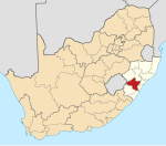
The Ugu District Municipality is one of the 11 districts of the KwaZulu-Natal province of South Africa. Ugu is isiZulu for "coast". It governs the KZN South Coast and its seat is Port Shepstone. The majority of its 722,484 inhabitants spoke isiZulu as of 2011. The district code is DC21.

The Harry Gwala District Municipality, formerly the Sisonke District Municipality, is one of the 11 districts of the KwaZulu-Natal province of South Africa. The seat is Ixopo. The majority of its 298,392 inhabitants spoke isiZulu as of 2011. The district code is DC43. The district's name was changed in November 2015 in honor of African National Congress leader Harry Gwala.

The uMkhanyakude District Municipality is the northernmost of the 11 districts of the KwaZulu-Natal province of South Africa. Its seat is Mkuze. It is a very rural district, the largest town being Mtubatuba in the south, with Hluhluwe, Mkuze, Jozini, Kwangwanase and Ingwavuma further to the north. The majority of its 573,353 inhabitants spoke isiZulu as of 2001. The district code is DC27.

Gert Sibande is one of the 3 districts of Mpumalanga province of South Africa. The seat of Gert Sibande is Ermelo. The majority of its 900 007 people speak IsiZulu. The district code is DC30. On 15 October 2004, the municipality changed its name from the "Eastvaal" to "Gert Sibande" District Municipality. The district is named after the ANC activist Gert Sibande.
Nkangala is one of the 3 districts of Mpumalanga province of South Africa. The seat of Nkangala is Middelburg. The Nkangala District Municipality consists of 160 towns and villages. The most spoken language of its 1,308,129 people is IsiNdebele with 28.4%, closely followed by Zulu speakers. The district code is DC31.

Msunduzi Municipality is a local municipality within the Umgungundlovu District Municipality, in the KwaZulu-Natal province of South Africa. It encompasses the city of Pietermaritzburg, which is the capital of KwaZulu-Natal and the main economic hub of the Umgungundlovu District Municipality.

uMngeni Municipality is a local municipality within the Umgungundlovu District Municipality, in the KwaZulu-Natal province of South Africa. The municipality is named after the uMngeni River that runs through the municipal area.

Umzimkhulu Municipality is a local municipality within the Harry Gwala District Municipality, in the KwaZulu-Natal province of South Africa. Umzimkhulu is an isiXhosa and isiZulu word meaning "big/great house". Prior to the Twelfth Amendment of the Constitution of South Africa in 2005, confirmed by the Thirteenth in 2007, it was part of the Eastern Cape.

Mpofana Municipality is a local municipality within the Umgungundlovu District Municipality, in the KwaZulu-Natal province of South Africa.
Richmond Municipality is a local municipality within the Umgungundlovu District Municipality, in the KwaZulu-Natal province of South Africa.

Impendle Municipality is a local municipality wirhin the Umgungundlovu District Municipality, in the KwaZulu-Natal province of South Africa. During the 18th century, the Griquas ("Abatwas") used to hide in the mountain in the area because they were accused of stealing livestock from the farmers who decided to fight the Griquas in order to protect their livestock. The Griquas used war spears, and this conflict was called "an outside war", i.e. impiyasendle or impiendle.
UMshwathi Local Municipality is situated in UMgungundlovu District Municipality (UMDM) which is in the foothills of the province of KwaZulu-Natal, about 120 km northwest of Durban, geographically located between the N2 and the N3 highways. The municipality is the largest Municipality in the largest district of KZN out of the seven Local Municipalities which form UMDM.

Mkhambathini Municipality is a local municipality within the Umgungundlovu District Municipality, in the KwaZulu-Natal province of South Africa. Mkhabathini is an isiZulu word derived from eMkhambathini meaning "the place of acacia trees".

The eThekwini Metropolitan Municipality is a metropolitan municipality, created in 2000, that includes the city of Durban and surrounding towns. eThekwini is one of the 11 districts of the KwaZulu-Natal province of South Africa. As of 2011, the majority of its 3,442,361 inhabitants spoke isiZulu.