UMlalazi Local Municipality

Last updated
uMlalazi
UMlalazi CoA.png
Map of KwaZulu-Natal with Umlalazi highlighted.svg
Location in KwaZulu-Natal
Country South Africa
Province KwaZulu-Natal
District King Cetshwayo
Seat Eshowe
Wards 26
Government
[1]
  Type Municipal council
  MayorCouncillor T B Zulu
Area
  Total2,214 km2 (855 sq mi)
Population
 (2016) [2]
  Total223,140
  Density100/km2 (260/sq mi)
Racial makeup (2011)
[2]
   Black African 97.1%
   Coloured 0.6%
   Indian/Asian 0.7%
   White 1.5%
First languages (2011)
[3]
   Zulu 92.1%
   English 3.5%
   Southern Ndebele 1.3%
  Other3.1%
Time zone UTC+2 (SAST)
Municipal codeKZN284

uMlalazi Local Municipality is an administrative area in the King Cetshwayo District of KwaZulu-Natal in South Africa. The municipality is named after the uMlalazi River. [4]

Contents

Main places

The 2001 census divided the municipality into the following main places: [5]

PlaceCodeArea (km2)Population
Amatikulu 54001 1.38732
Bangindoda 54002 126.377,112
Bhekabelungu Biyela 54003 7.32923
Bhekeshowe 54004 79.5311,789
Dinuzulu 54005 1.446,374
Emangidini 54006 6.86648
Entembeni 54007 7.15477
Eshowe 54008 16.335,230
Gingindlovu 54009 2.291,157
Khoza 54010 69.3911,387
Kolweni 54011 19.383,583
KwaMondi 54012 20.466,651
Mombeni 54013 138.8810,829
Mpungose 54014 173.3826,955
Mpushini Park 54015 2.72327
Mtunzini 54016 10.591,273
Mvuzane 54017 91.289,935
Mxhwanazi 54018 2.72760
Mzimela 54019 241.8529,731
Ndlangubo 54020 48.679,013
Ntuli 54021 329.5622,189
Nzuza 54022 85.3921,363
Sabeka 54023 5.99212
Shange 54024 109.2013,476
Sikhonyane 54025 14.291,231
Umgoye Forest 54026 39.026
Vuma 54028 7.850
Zulu 54029 14.625,710
Remainder of the municipality 54027 540.2112,007

Politics

The municipal council consists of fifty-five members elected by mixed-member proportional representation. Twenty-eight councillors are elected by first-past-the-post voting in twenty-eight wards, while the remaining twenty-seven are chosen from party lists so that the total number of party representatives is proportional to the number of votes received. In the election of 1 November 2021 the Inkatha Freedom Party (IFP) won a majority of thirty seats on the council. The following table shows the results of the election. [6]

PartyWardListTotal
seats
Votes%SeatsVotes%Seats
Inkatha Freedom Party 27,55552.752428,28754.17630
African National Congress 16,92932.41417,17032.881418
Economic Freedom Fighters 3,5446.7803,4116.5344
Abantu Batho Congress 9191.7608781.6811
Democratic Alliance 7641.4608891.7011
National Freedom Party 4690.9005781.1111
Independent candidates 9861.8900
People's Freedom Party 5581.0704080.7800
The Organic Humanity Movement 1430.2701180.2300
African Christian Democratic Party 1180.2301260.2400
Academic Congress Union 920.180750.1400
African People's Convention 550.110870.1700
African People's Movement 430.080610.1200
Independent South African National Civic Organisation 220.040730.1400
African Transformation Movement 370.070560.1100
Total52,234100.002852,217100.002755
Valid votes52,23497.9852,21798.14
Invalid/blank votes1,0752.029911.86
Total votes53,309100.0053,208100.00
Registered voters/turnout106,31750.14106,31750.05

Related Research Articles

Nelson Mandela Bay Metropolitan Municipality Metropolitan municipality in Eastern Cape, South Africa

Nelson Mandela Bay Municipality is one of eight metropolitan municipalities in South Africa. It is located on the shores of Algoa Bay in the Eastern Cape Province and comprises the city of Gqeberha, the nearby towns of Uitenhage and Despatch, and the surrounding rural area.

Tswaing Local Municipality Local municipality in North West, South Africa

Tswaing Local Municipality is a local Municipality consisting of the towns of Delareyville, Sannieshof and Ottosdal in the Central District Municipality situated in the North West Province of South Africa.

KwaDukuza Local Municipality Local municipality in KwaZulu-Natal, South Africa

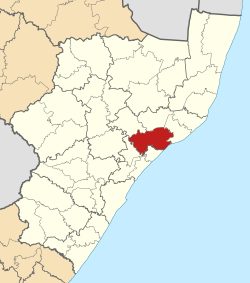
KwaDukuza Local Municipality is one of four municipalities under iLembe District Municipality, KwaZulu-Natal, South Africa.

Moretele Local Municipality Local municipality in North West, South Africa

Moretele is a local municipality in Bojanala Platinum District Municipality, North West Province, South Africa. Population: 180,000.

Ditsobotla Local Municipality Local municipality in North West, South Africa

Ditsobotla Local Municipality is a local municipality in Ngaka Modiri Molema District Municipality, North West Province, South Africa. The seat of local municipality is Lichtenburg.

Greater Taung Local Municipality Local municipality in North West, South Africa

Greater Taung Local Municipality is a local municipality in Dr Ruth Segomotsi Mompati District Municipality, North West Province, South Africa. The Seat of local municipality is Taung.

Ratlou Local Municipality Local municipality in North West, South Africa

Ratlou Local Municipality is a local municipality in Ngaka Modiri Molema District Municipality, North West Province, South Africa.

Metsimaholo Local Municipality Local municipality in Free State, South Africa

Metsimaholo Local Municipality is an administrative area in the Fezile Dabi District of the Free State in South Africa. "Metsimaholo" means "big water" in Sesotho.

uMngeni Local Municipality Local municipality in KwaZulu-Natal, South Africa

uMngeni Local Municipality is an administrative area in the UMgungundlovu District of KwaZulu-Natal in South Africa.

uMhlathuze Local Municipality Local municipality in KwaZulu-Natal, South Africa

uMhlathuze Local Municipality is an administrative area in the King Cetshwayo District Municipality of KwaZulu-Natal in South Africa. The municipality is named after the Mhlatuze River.

Maphumulo Local Municipality Local municipality in KwaZulu-Natal, South Africa

Maphumulo Local Municipality is an administrative area in the iLembe District of KwaZulu-Natal in South Africa. Maphumulo is an isiZulu name meaning "place of rest".

Tokologo Local Municipality Local municipality in Free State, South Africa

Tokologo Local Municipality is an administrative area in the Lejweleputswa District of the Free State in South Africa. The name is a Setswana word meaning "freedom".

Elundini Local Municipality Local municipality in Eastern Cape, South Africa

Elundini Local Municipality is an administrative area in the Joe Gqabi District Municipality of the Eastern Cape in South Africa.

Msinga Local Municipality Local municipality in KwaZulu-Natal, South Africa

Msinga Local Municipality is an administrative area in the Umzinyathi District of KwaZulu-Natal in South Africa. The name means a current in the sea where air movement causes ripples on top of the water surface and ends up influencing the nearby climatic conditions through its breeze.

Mtubatuba Local Municipality Local municipality in KwaZulu-Natal, South Africa

Mtubatuba is an administrative area in the Umkhanyakude District of KwaZulu-Natal in South Africa.

Emalahleni Local Municipality, Eastern Cape Local municipality in Eastern Cape, South Africa

Emalahleni Local Municipality is an administrative area in the Chris Hani District of the Eastern Cape in South Africa. Emalahleni is an isiXhosa name meaning "a place of coal".

Mhlontlo Local Municipality Local municipality in Eastern Cape, South Africa

Mhlontlo Local Municipality is an administrative area in the OR Tambo District of Eastern Cape in South Africa.

Engcobo Local Municipality Local municipality in Eastern Cape, South Africa

Engcobo Local Municipality is an administrative area in the Chris Hani District of the Eastern Cape in South Africa. Ngcobo is an isiXhosa name for a sweet grass found in the area.

Mthonjaneni Local Municipality Local municipality in KwaZulu-Natal, South Africa

Mthonjaneni is an administrative area in the King Cetshwayo District of KwaZulu-Natal in South Africa.

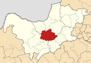
The uMlalazi Local Municipality council consists of fifty-five members elected by mixed-member proportional representation. Twenty-eight councillors are elected by first-past-the-post voting in twenty-eight wards, while the remaining twenty-seven are chosen from party lists so that the total number of party representatives is proportional to the number of votes received. In the election of 1 November 2021 the Inkatha Freedom Party (IFP) won a majority of thirty seats on the council.

References

  1. "Contact list: Executive Mayors". Government Communication & Information System. Archived from the original on 14 July 2010. Retrieved 22 February 2012.
  2. 1 2 "Statistics by place" (PDF). Statistics South Africa. Retrieved 9 June 2020.
  3. "Statistics by place". Statistics South Africa. Retrieved 27 September 2015.
  4. South African Languages - Place names
  5. Lookup Tables - Statistics South Africa
  6. "Election Result Table for LGE2021 — uMlalazi". wikitable.frith.dev. Retrieved 2021-12-16.

Coordinates: 28°53′03″S31°28′08″E / 28.88417°S 31.46889°E / -28.88417; 31.46889