
The Hungerford Bridge crosses the River Thames in London, and lies between Waterloo Bridge and Westminster Bridge. Owned by Network Rail Infrastructure Ltd it is a steel truss railway bridge flanked by two more recent, cable-stayed, pedestrian bridges that share the railway bridge's foundation piers, and which are named the Golden Jubilee Bridges.
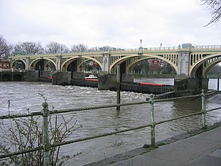
Richmond Lock and Footbridge is a lock, rising and falling low-tide barrage integrating controlled sluices and pair of pedestrian bridges on the River Thames in south west London, England and is a Grade II* listed structure. It is the furthest downstream of the forty-five Thames locks and the only one owned and operated by the Port of London Authority. It was opened in 1894 and is north-west of the centre of Richmond in a semi-urban part of south-west London. Downstream are Syon Park and Kew Gardens on opposite banks. It connects the promenade at Richmond with the neighbouring district of St. Margarets on the west bank during the day and is closed at night to pedestrians – after 19:30 GMT or after 21:30 when BST is in use. At high tide the sluice gates are raised and partly hidden behind metal arches forming twin footbridges.

The Tees Barrage is a barrage and road bridge across the River Tees, Northern England, just upriver of Blue House Point and is used to control the flow of the river, preventing flooding and the effects of tidal change. It is between the towns of Stockton-on-Tees and Thornaby, road access is only by the latter with limited road access to the Tees's north bank.

The Thames Path is a National Trail following the River Thames from its source near Kemble in Gloucestershire to the Thames Barrier at Charlton, south east London. It is about 184 miles (296 km) long. A path was first proposed in 1948 but it only opened in 1996.

Folly Bridge is a stone bridge over the River Thames carrying the Abingdon Road south from the centre of Oxford, England. It was erected in 1825–27, to designs of a little-known architect, Ebenezer Perry, who practised in London.

Hambleden Lock is a lock with a long weir situated on the River Thames in England, about 2 miles downstream of Henley Bridge. The lock is on the Berkshire bank between Aston and Remenham. Built by the Thames Navigation Commission in 1773, the lock is named after the village of Hambleden, a mile (1.5 km) to the north.

Osney or Osney Island is a riverside community in the west of the city of Oxford, England. In modern times the name is applied to a community also known as Osney Town astride Botley Road, just west of the city's main railway station, on an island surrounded by the River Thames, Osney Ditch and another backwater connecting the Thames to Osney Ditch.

Day's Lock is a lock on the River Thames near Dorchester-on-Thames, Oxfordshire, England on the Dorchester side of the river.

Culham Lock is a lock on the River Thames in England close to Culham, Oxfordshire. It is on a lock cut to the north of the main stream, which approaches the large village of Sutton Courtenay. The lock was built of stone by the Thames Navigation Commission in 1809.

Shifford Lock is a lock on the River Thames in England. It is in the centre of a triangle formed by the small villages of Shifford, Duxford and Chimney in Oxfordshire. It is at the start of a navigation cut built with the lock by the Thames Conservancy in 1898. This was the only new lock built on the non-tidal Thames in the era of falling revenue after the Thames Conservancy took over responsibilities of the Thames Navigation Commission. It replaced a flash lock in a weir about 3⁄4 mile (1.2 km) downstream.

Buscot Lock is a lock on the River Thames in England, near the village of Buscot, Oxfordshire.

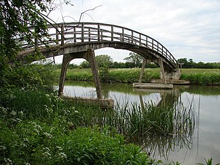
Tenfoot Bridge is a wooden footbridge across the River Thames in Oxfordshire, England. It is situated on the reach above Shifford Lock and was built in 1869. It connects Buckland on the south bank to Chimney on the north.

Nuneham Railway Bridge, known as the Black Bridge. is near the town of Abingdon in Oxfordshire, England. It carries the Cherwell Valley Line across the River Thames between Abingdon Lock and Sandford Lock on the line between Didcot and Oxford.

Isis Bridge is a modern road bridge across the River Thames just south of Oxford, England. It carries the Oxford Ring Road, part of the A423 road, across the Thames on the reach between Sandford Lock and Iffley Lock.
Hart's Weir Footbridge is a single-span concrete footbridge across the River Thames in Oxfordshire, England. Locally, it is also known as Rainbow Bridge, due to its rainbow-arc appearance as seen from the horizon. It is situated on the reach above Northmoor Lock, the nearest village being Appleton, Oxfordshire to the east.
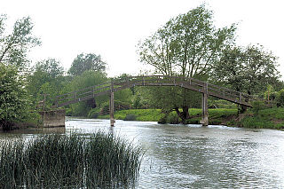
Old Man's Bridge is a wooden footbridge across the River Thames in Oxfordshire, England. It is situated on the reach above Rushey Lock, a short way downstream of Radcot Lock.

Eaton Footbridge is a wooden footbridge across the River Thames in Oxfordshire, England. It is situated on the reach above Grafton Lock.

Little Wittenham Bridge is a footbridge across the River Thames in England near Dorchester-on-Thames, Oxfordshire. It is just downstream of Day's Lock on the reach above Benson Lock and connects Little Wittenham to Dorchester.

Sheepwash Channel connects the River Thames to the west and the Castle Mill Stream next to the Oxford Canal to the east, in west Oxford, England. To the north are Cripley Meadow and Fiddler's Island. To the south are Osney Island and the Botley Road.

