Thames Path

Last updated

Thames Path
Thames Path sign, Thames Barrier.jpg
The Thames Path sign near the end of the walk, by the Thames Barrier
Length185 mi (298 km)
LocationSouthern England, United Kingdom
Designation UK National Trail
Trailheads Kemble, Gloucestershire and Woolwich
UseHiking, cycling
Elevation change 110m
Highest point110m
Lowest point0m
DifficultyEasy
SeasonAll year
Sights London, Hampton Court, Windsor, Oxford, Lechlade, Cricklade
Hazards flooding

The Thames Path is a National Trail following the River Thames from one of its sources near Kemble in Gloucestershire to the Woolwich foot tunnel, south east London. It is about 185 miles (298 km) long. [1] [2] A path was first proposed in 1948 but it only opened in 1996. [3] [4]

Contents

The Thames Path's entire length can be walked, and a few parts can be cycled. Some parts of the Thames Path, particularly west of Oxford, are subject to flooding during the winter. The river is also tidal downstream from Teddington Lock and the lower parts of these paths may be underwater if there is a particularly high tide, although the Thames Barrier protects London from catastrophic flooding.

The Thames Path uses the river towpath between Inglesham and Putney and available paths elsewhere. Historically, towpath traffic crossed the river using many ferries, [5] but few of these crossings exist now and some diversion from the towpath is necessary.

Description and access to the river

The general aim of the path is to provide walkers with a pleasant route alongside the river. The way this is achieved naturally falls into three distinct areas, depending on the nature of the river in the area.

The unnavigable upper river

In the absence of a tow path, the Thames Path uses all available riverside rights of way between the traditional source of the river in Trewsbury Mead and Inglesham, but is unable to run alongside the river in several places.

Thames Head ThamesMarker.JPG
Thames Head

The Thames Path starts beside the monument for the traditional river source and follows the water down the hill towards the Fosse Way. In the fields either side of the A433 are some springs; and south of this road, a small water channel can be found and then a pool and small weir, before reaching the A429 bridge near Kemble. On the stretch between Ewen and Somerford Keynes the bourne passes through fields and there are a number of watermills. [6] The path then follows the watercourse through the Cotswold Water Park to Ashton Keynes, where the water divides into a number of streams; the Thames Path partly follows one of these and rejoins the river by Waterhay Bridge. [7] Downstream from this point canoeing in the river is practical. The path wanders to and from the river amongst more gravel pits until Hailstone Hill, where a riverside path starts by the old railway line. A little further, the North Wilts canal from Latton formerly crossed the river on an aqueduct and ran alongside and south of the river to West Mill Lane. [8] Here the path leaves the river to go through Cricklade, past Cricklade Town Bridge, rejoining the river east of the town, and now follows the river all the way downstream to Castle Eaton. The path next follows country lanes, a short stretch along a backwater to Hannington Bridge then goes across fields to Inglesham. [9] In 2018 the path incorporated a section of permissive path alongside the river at Upper Inglesham. [10]

Above Inglesham the river is not dredged and being without weirs to control water levels, it is often shallow, weedy and swift but after heavy rain flooding of the riverside paths is common. Today the Environment Agency (the current successor to the Thames Conservancy) is the navigation authority responsible for the Thames between Cricklade and Teddington. The navigation towpath starts from Inglesham (just upstream of Lechlade), as does the ability to navigate the river for all but very small boats, although there were once weirs with flash locks to enable passage as far as Cricklade, and there is still a right of navigation up to Cricklade. [11] The navigation above Lechlade clearly must have been neglected after the Thames and Severn Canal provided an easier route by canal for barge traffic [12] and not all of the river downstream from Cricklade has a footpath alongside.

The navigable river with locks and towpath

The Thames Path uses the existing Thames towpath between Inglesham and Putney Bridge wherever possible. The former Thames and Severn Canal entrance is the present-day limit of navigation [13] [14] for powered craft, and is one and a half miles upstream of the highest lock (St John's Lock), near Lechlade. [15] Today, between the canal entrance and Putney Bridge, the towpath still allows access by foot to at least one side of the river for almost the whole length of the main navigation of the river, but not mill streams, backwaters or a few meanders cut off by lock cuttings, since towpaths were originally only intended to enable towing of barges on the navigation.

Thames and Severn Canal and River Coln joining the Thames with former canal warehouse to left and Round House behind it, covered in greenery Inglesham Round House - geograph.org.uk - 3260.jpg
Thames and Severn Canal and River Coln joining the Thames with former canal warehouse to left and Round House behind it, covered in greenery

Origin of the towpath

The Thames has been used for navigation for a long time, [12] although owners of weirs, locks and towpath often charged tolls. The towpath owes its existence, in its current form, to the Industrial Revolution and the Canal Mania of the 1790s to 1810s, and so is related to the history of the British canal system. The Thames already allowed for passage onto the River Kennet Navigation and River Wey Navigation, but this period in history also saw the Wilts & Berks Canal, the Oxford Canal and the Thames and Severn Canal connected to the non-tidal Thames. It was not until a little after the Thames Navigation Commission were enabled by a 1795 Act of Parliament [16] to purchase land for a continuous horse path that the non-tidal navigation (and hence the towpath) was consolidated as a complete route under a single (toll charging) authority, upstream to Inglesham. This improved the ability of horse-drawn barge traffic to travel upstream to the Thames and Severn Canal, which had opened in 1789 and provided an alternative route (also using the Wilts & Berks Canal) for boat traffic to Cricklade. The commissioners had to create horse ferries to join up sections of towpath (for example at Purley Hall), as the Act did not allow them to compulsorily purchase land near an existing house, garden or orchard. The City of London Corporation, who had rights and responsibilities for the Thames below Staines from a point marked by the London Stone, had similarly bought out the towpath tolls of riparian land owners as enabled by an earlier Thames Navigation Act in 1776. [12]

From the 1840s, the development of the railways and steam power gradually made redundant the need for horse-drawn barges on the non-tidal Thames, although people were still using the towpath to tow small pleasure boats in 1889. [17] The towpath route has not changed since then, apart from now following Shifford lock cut; however, over time the towpath ferries became obsolete and the last towpath ferry to stop running was the rope ferry at Bablock Hythe in the 1960s. [18]

Cliveden from the River Thames Bavin's Gulls on the River Thames at Cliveden Deep (Nancy).JPG
Cliveden from the River Thames

Deviations

The main exception to towpath access to the navigation between Inglesham and Putney is a stretch of river where the former towpath was removed past Windsor Castle. The castle's private grounds of Home Park, Windsor were extended to include the riverbank and its towpath by the Windsor Castle Act 1848, also involving the building of Victoria and Albert bridges and the removal of Datchet Bridge. [19] This accounts for the Thames Path's diversion from the river at Datchet. There are two other short lengths of navigation which have no towpath: one between Marlow bridge and lock (which never had a towpath), and one past Whitchurch lock either side of The Swan public house in Pangbourne (where the towpath has been lost). At both these weirs, lengthy rope winches were required for barges to pass Marlow and Whitchurch in the days before steam power. It is also required to divert around Oxford Cruisers downstream of Pinkhill Lock, even though the towpath is still shown as a public right of way on Ordnance Survey maps. [20] The remainder of the navigation between Inglesham and Putney has an existing towpath; however, river crossings are now missing at the sites of 15 former ferries and one former lock, so the Thames Path makes 11 other diversions from the remaining towpath because of the lack of a river crossing at their original locations. There is also a twelfth temporary diversion at Hammersmith Bridge, described below.

Walkers can visit the lengths of river navigation not on the Thames Path using the current towpath, except for two isolated sections of towpath not connected by any public path (or ferry) at either end. The first is a short section of path on the north bank opposite Purley-on-Thames; this is still shown on Ordnance Survey maps but is inaccessible except by boat, caused by the lack of two ferries formerly diverting around Purley Hall. [21] The second and furthest downstream is a particularly picturesque section of towpath (again shown on OS maps) within the National Trust grounds of Cliveden; here the lack of three ferries accounts for the Thames path's diversion from the river at Cookham. [22]

When Cookham Lock was built in 1830, Hedsor Water became a backwater and lost its towpath. Around 1822, Clifton and Old Windsor locks were built, with lock cuttings which cut across river meanders; here the towpath was rerouted along the lock cuttings and there is no public riverside access to these river meanders. However, some stretches of river bypassed by navigation cuttings still retain public footpath access: firstly at Desborough Island (formed by Desborough Cut); secondly, parts of older towpath accessible at Duxford (towpath now follows Shifford Lock cut); and lastly, the river meander at Culham. The Culham meander is accessible, even though only parts are designated as public footpath (towpath now follows Culham Lock cut) and there is also riverside public footpath along the ancient causeway past Sutton Pools. [23]

Temple Footbridge, built in 1989 for the Thames Path TempleFootbridge01.JPG
Temple Footbridge, built in 1989 for the Thames Path

Changes to crossings

Historically, there have been replacements for towpath ferry crossings with bridges at Goring and Clifton Hampden and the path across the weir at Benson Lock (the towpath ferry was upstream). [24] In recent times, crossings have been created for the Thames Path; the Shepperton to Weybridge Ferry was restarted in 1986, Temple Footbridge near Hurley was built in 1989, a footpath was attached to Bourne End Railway Bridge in 1992 (the ferry was upstream), [25] and Bloomers Hole Footbridge was built in 2000. No other replacement river crossings have been created for lapsed ferries, so the Thames Path must divert away from the river and the towpath to cross the river elsewhere, leaving some sections of towpath not on the Thames path.

Penton Hook Lock, which has City of London arms on the original lock-keepers house PentonHLock.JPG
Penton Hook Lock, which has City of London arms on the original lock-keepers house

Locks

Many walkers visit the locks on the River Thames and in summer some have facilities open for visitors. A few have small campsites. The locks at Cookham and Whitchurch are not on the Thames Path and require some effort to visit. Whitchurch Lock cutting was built through an island in the river and public access to the lock over the weir from Pangbourne or across the millstream at Whitchurch-on-Thames was closed in 1888 to avoid the loss of tolls on Whitchurch Bridge; as a consequence, Whitchurch is the only Thames lock that is inaccessible by foot – it is only accessible by boat. [26] Cookham Lock is still accessible although it is not on the Thames Path. The Thames divides into several streams here and the towpath does not connect up without ferries; access to this lock requires a 10-minute walk across Odney Common on Formosa Island and the Lock Island (incorporating the former Mill Eyot) to Sashes Island. [27] Marlow Lock access requires a short walk through town back streets. All the other locks have obvious access from the Thames Path.

The lock islands at Pinkhill Lock, Eynsham Lock, King's Lock, Boulters Lock and Shepperton Lock can be visited, as can Penton Hook Island which is a meander cutoff formed when Penton Hook Lock was built. Any public footpaths that cross or go along any of the other small islands formed by construction of the Thames locks only allow access to the path alone.

Lock building by the Thames Commissioners had improved the whole river navigation from Inglesham to the upper limit of the tidal reach at Staines by 1789. On the tidal Thames below Staines, six new locks were built by the City of London Corporation to improve the navigation between 1811 and 1815. The Thames Conservancy was established in 1857 to take over duties from the City of London because of falling revenue from boat traffic; it also took on the duties of the Thames Commissioners in 1866. [16] Provision for pleasure boating was now the main purpose, [17] and although the Thames Conservancy rebuilt many locks, upgrading some from flash locks to pound locks, and made navigation and towpath improvements, it only built one completely new lock on the non-tidal Thames, at Shifford in 1898.

The tidal river

There is a Thames Path on both sides of the river downstream of Teddington Lock, the southern path including the original towpath as far as Putney Bridge.

The Boat Race, viewed from Chiswick Bridge, looking at the crowds on the southern (Surrey) bank towpath Finish of 2007 Oxford-Cambridge boat race.JPG
The Boat Race, viewed from Chiswick Bridge, looking at the crowds on the southern (Surrey) bank towpath

Because of the locks built by the City of London, the river is now tidal only downstream from Teddington Lock, although during spring tides flood warnings are sometimes issued upstream towards Molesey Lock. A further lock with a low-tide barrage (rather than a weir) was built by the Thames Conservancy in 1894 downstream at Richmond Lock to improve the navigation by maintaining water level upstream to at least half-tide level. Today, the Port of London Authority is the navigation authority that manages the tidal river, including Richmond Lock and barrage. Wharfs and jetties are generally confined to the northern (Middlesex) bank between Richmond and Putney. This stretch of tideway (known as the Upper Rowing Code Area) has special navigation rules to accommodate the activities of a number of rowing clubs, and includes the course used for The Boat Race. Chiswick Eyot is on this section and is notable as being the only tidal island on the river.

Since August 2020, the towpaths on both banks have been closed under Hammersmith Bridge because of cracks in the structure; walkers and cyclists must therefore divert from the river at the bridge until they reach the adjacent road (Castelnau on the south bank, Hammersmith Bridge Road on the north) and then cross the road at the nearest safe point before returning to the river.

The Millennium Footbridge with St Paul's Cathedral in the background London millennium wobbly bridge.jpg
The Millennium Footbridge with St Paul's Cathedral in the background

Historical records state that the towpath started at Putney. [28] Downstream of here sailing, sculling and rowing, and following the current (or rising and falling tide) were the means of movement until the 19th century, [17] Thames sailing barges being typical. Moderately straight lengths of the tideway are often called reaches, as they can be sailed without tacking. Crossing the river was more of a priority, as evidenced by the many watermen's stairs giving watermen and passengers access to the tidal river. [29] Thames steamers became more common for transport on the tidal Thames from 1815 until the railways dominated public transport. Falling income from river traffic and disputes over the construction of Victoria Embankment because of Crown Estate ownership of the tidal riverbed [30] led to the City of London's seceding management of their part of the river to the Thames Conservancy in 1857; and the section below Teddington was further passed on to the Port of London Authority in 1908. Construction of riverside buildings and structures often meant embanking the tidal Thames and acquiring riverbed ownership. The historical progression of so many construction works, is why there is not continuous foreshore access for a riverside path within the Port of London. Today, downstream of Putney, there are jetties and wharfs on both banks of the river, and sections of the Thames Path often have to divert away from the river around riverside buildings. [31] There are also many docks, most of them downstream of Tower Bridge.

In central London, there is much of interest. The Thames Path is one of the Mayor of London's strategic walking routes. [32] The Thames Path Cycle Route is a black-signposted route that follows the river between Putney Bridge in the west and Greenwich in the east. It mostly follows the Thames Path, but diverges in various sections, especially where the path follows a footpath-only route. It also links National Cycle Route 1 (east of London) with National Cycle Route 4 (west of London). [33]

Route

The route of the Thames Path can be divided into these sections:

The Shepperton to Weybridge Ferry reopened 1986 Shepperton to Weybridge Ferry.jpg
The Shepperton to Weybridge Ferry reopened 1986

Thames crossings

Bloomers Hole Footbridge, built in 2000 in commemoration of the Millennium for the Thames Path Bloomers Hole Footbridge.jpg
Bloomers Hole Footbridge, built in 2000 in commemoration of the Millennium for the Thames Path

The list below gives the points where the Thames Path crosses the river between Cricklade and Teddington. Above Cricklade, the Thames is a stream and in some places there may be no water except after rain. Below Teddington there are paths on both sides of the river until the Greenwich foot tunnel, after which the path is only on the south.

The list is in downstream order. The letter in brackets indicates whether the path downstream of that point takes the northern or southern bank (using north or south in reference to the river as a whole, rather than at that specific point).

Bridges and ferries are listed in full under Crossings of the River Thames. The river can be crossed at about a third of the locks, although some of these crossings are not part of the Thames Path.

Related Research Articles

<span class="mw-page-title-main">River Thames</span> River in southern England

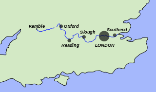
The River Thames, known alternatively in parts as the River Isis, is a river that flows through southern England including London. At 215 miles (346 km), it is the longest river entirely in England and the second-longest in the United Kingdom, after the River Severn.

<span class="mw-page-title-main">Locks and weirs on the River Thames</span>

The English River Thames is navigable from Cricklade or Lechlade to the sea, and this part of the river falls 71 meters (234 feet). There are 45 locks on the river, each with one or more adjacent weirs. These lock and weir combinations are used for controlling the flow of water down the river, most notably when there is a risk of flooding, and provide for navigation above the tideway.

<span class="mw-page-title-main">Richmond Lock and Footbridge</span> Lock and pedestrian bridges in London, England

Richmond Lock and Footbridge is a lock, rising and falling low-tide barrage integrating controlled sluices and pair of pedestrian bridges on the River Thames in southwest London, England, and is a Grade II* listed structure. It is the furthest downstream of the forty-five Thames locks and the only one owned and operated by the Port of London Authority. It was opened in 1894 and is north-west of the centre of Richmond in a semi-urban part of southwest London. Downstream are Syon Park and Kew Gardens on opposite banks. It connects the promenade at Richmond with the neighbouring district of St. Margarets on the west bank during the day and is closed at night to pedestrians – after 19:30 GMT or after 21:30 when BST is in use. At high tide the sluice gates are raised and partly hidden behind metal arches forming twin footbridges.

<span class="mw-page-title-main">Teddington Lock</span> Series of locks on the River Thames in London

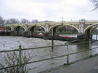
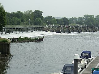
Teddington Lock is a complex of three locks and a weir on the River Thames between Ham and Teddington in the London Borough of Richmond upon Thames, England. Historically in Middlesex, it was first built in 1810.

<span class="mw-page-title-main">Marsh Lock</span> Lock and weir on the River Thames in Berkshire, England

Marsh Lock is a lock and weir situated on the River Thames in England, about 1 mile upstream of Henley Bridge in Henley-on-Thames, Oxfordshire. The lock is close to the Berkshire bank, but accessed from the Oxfordshire side via two long walkways, the downstream one being near Mill Meadows. The first pound lock was built by the Thames Navigation Commission in 1773.

<span class="mw-page-title-main">Cookham Lock</span> Lock and weirs on the River Thames in Berkshire, England

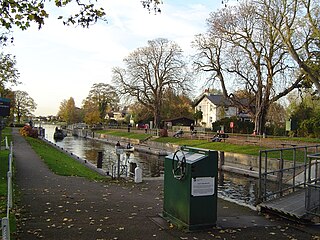
Cookham Lock is a lock with weirs situated on the River Thames near Cookham, Berkshire, about a half-mile downstream of Cookham Bridge. The lock is set in a lock cut which is one of four streams here and it is surrounded by woods. On one side is Sashes Island and on the other is Mill Island connected to Formosa Island, the largest on the non-tidal Thames.

<span class="mw-page-title-main">Teddington Lock Footbridges</span> Two footbridges on the River Thames in London

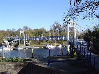
The Teddington Lock Footbridges are two footbridges over the River Thames in England, situated just upstream of Teddington Lock at Teddington. There is a small island between the bridges.

<span class="mw-page-title-main">Thames Conservancy</span> United Kingdom legislation

The Thames Conservancy was a body responsible for the management of that river in England. It was founded in 1857 to replace the jurisdiction of the City of London up to Staines. Nine years later it took on the whole river from Cricklade in Wiltshire to the sea at Yantlet Creek on the Isle of Grain. Its territory was reduced when the Tideway was transferred to the Port of London Authority in 1909.

<span class="mw-page-title-main">Tideway</span> Part of the River Thames subject to tides

The Tideway is a part of the River Thames in England which is subject to tides. This stretch of water is downstream from Teddington Lock. The Tideway comprises the upper Thames Estuary including the Pool of London.

<span class="mw-page-title-main">Boulter's Lock</span> Lock and weir on the River Thames, England

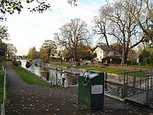
Boulter's Lock is a lock and weir on the River Thames in England north-east of Maidenhead town centre, Berkshire. The present 1912-built lock replaces those at this point of the river to the immediate east dating from the late 16th century and that of 1772 built by the Thames Navigation Commission. The lock is on the western side of the north-south flowing reach between the A4094 Maidenhead to Cookham road and Ray Mill Island. The name is variably used for the immediate surrounding area.

<span class="mw-page-title-main">Clifton Lock</span>

Clifton Lock is a lock on River Thames in Oxfordshire, England. It is located south of the village of Clifton Hampden and north of Long Wittenham. It is at the start of the Clifton Cut, which bypasses the river to the north of Long Wittenham. The lock was completed in 1822 by the Thames Navigation Commissioners.

<span class="mw-page-title-main">St John's Lock</span> Lock on the River Thames in Gloucestershire, England

St John's Lock, below the town of Lechlade, Gloucestershire, is the furthest upstream lock on the River Thames in England. The name of the lock derives from a priory that was established nearby in 1250, but which no longer exists. The lock was built of stone in 1790 by the Thames Navigation Commission.

<span class="mw-page-title-main">Temple Lock</span> Lock and weir on the River Thames in Buckinghamshire, England

Temple Lock is a lock and weir situated on the Buckinghamshire bank of the River Thames near Temple Mill Island opposite Temple Meadows and not far from Hurley, Berkshire. It was first built by the Thames Navigation Commissioners in 1773.

<span class="mw-page-title-main">Marlow Lock</span> Lock and weir on the River Thames in Buckinghamshire, England

Marlow Lock is a lock and weir situated on the River Thames in the town of Marlow, Buckinghamshire, England, about 300m downstream of Marlow Bridge. The first pound lock was built by the Thames Navigation Commission in 1773.

<span class="mw-page-title-main">Sunbury Lock</span> Lock on the River Thames in Surrey, England

Sunbury Lock is a lock complex of the River Thames in England near Walton-on-Thames in north-west Surrey, the third lowest of forty four on the non-tidal reaches. The complex adjoins the right, southern bank about 12 mile (0.80 km) downstream of the Weir Hotel.

<span class="mw-page-title-main">Chertsey Lock</span> Lock on the River Thames in Surrey, England

Chertsey Lock is a lock on the River Thames in England, against the left bank, an area of Green Belt including Laleham Park, the largest public park in Spelthorne. It faces the town of Chertsey and is the fifth-lowest of the forty-four locks along the non-tidal course of the river. Owing to a course alteration both banks at the site of the lock have been since medieval times in Surrey. Stone-built Chertsey Bridge built in 1785 is 210 m south (downstream) of the lock. The lock was built by the City of London Corporation in 1813, lengthened in 1893 and again in 1913.

<span class="mw-page-title-main">Penton Hook Lock</span> Lock on the River Thames in Surrey, England

Penton Hook Lock is the sixth lowest lock of forty four on the non-tidal reaches of the River Thames in England. It faces an island which was until its construction a pronounced meander and is on the site of its seasonal cutoff. It is against the left bank marking the church parish medieval border of Laleham and Staines upon Thames in Surrey for many centuries. Until 1965 their county was Middlesex. At 266 ft (81 m) it is the third longest lock on the river.

<span class="mw-page-title-main">Cleeve Lock</span> Lock on the River Thames in Oxfordshire, England

Cleeve Lock is a lock on the River Thames, in Oxfordshire, England. It is located just upstream of Goring and Streatley villages, on the eastern side of the river within the village of Goring. There was a hamlet of Cleeve, after which the lock is named, but it dropped out of use, as always part of Goring.

<span class="mw-page-title-main">Shifford Lock</span> Lock on the River Thames, England

Shifford Lock is a lock on the River Thames in England. It is in the centre of a triangle formed by the small villages of Shifford, Duxford and Chimney in Oxfordshire. It is at the start of a navigation cut built with the lock by the Thames Conservancy in 1898. This was the only new lock built on the non-tidal Thames in the era of falling revenue after the Thames Conservancy took over responsibilities of the Thames Navigation Commission. It replaced a flash lock in a weir about 34 mile (1.2 km) downstream.

<span class="mw-page-title-main">Lea Valley Walk</span> Long-distance footpath in South East England

The Lea Valley Walk is a 50-mile (80 km) long-distance path located between Leagrave, the source of the River Lea near Luton, and the Thames, at Limehouse Basin, Limehouse, east London. From its source much of the walk is rural. At Hertford the path follows the towpath of the River Lee Navigation, and it becomes increasingly urbanised as it approaches London. The walk was opened in 1993 and is waymarked throughout using a swan logo.

References

  1. "Thames Path". National Trails. Walk Unlimited. Archived from the original on 26 May 2016. Retrieved 18 May 2016.
  2. "Thames Path National Trail". The Long Distance Walkers Association. Archived from the original on 9 August 2020. Retrieved 12 June 2019.
  3. "Thames Path". The Ramblers Association. Archived from the original on 31 July 2018. Retrieved 31 July 2018.
  4. "Thames Path". Transport for London. Retrieved 3 June 2022.
  5. Thacker, Fred S. (1968) [1920]. The Thames Highway: Volume II Locks and Weirs. David & Charles. Archived from the original on 20 February 2019. Retrieved 12 June 2019 via Where Thames Smooth Waters Glide.
  6. "The Thames Path, Ewen and Somerford Keynes". The Cotswold Gateway. Archived from the original on 27 November 2020. Retrieved 4 May 2021.
  7. "Walks in and around Ashton Keynes". Ashton Keynes. Archived from the original on 4 May 2021. Retrieved 4 May 2021.
  8. "Latton Basin". Latton Basin. Archived from the original on 4 May 2021. Retrieved 4 May 2021.
  9. "Cricklade to Lechlade". THames Path. Archived from the original on 29 December 2020. Retrieved 4 May 2021.
  10. "New route in place between Upper Inglesham and Inglesham". National Trails. Archived from the original on 4 May 2021. Retrieved 4 May 2021.
  11. "Cricklade". Where Thames Smooth Waters Glide. Archived from the original on 20 February 2019. Retrieved 12 June 2019.
  12. 1 2 3 Thacker, Fred S. (1914). The Thames Highway: Volume I General History. Archived from the original on 20 February 2019. Retrieved 12 June 2019 via Where Thames Smooth Waters Glide.
  13. John Eade. "Limit of Navigation". Thames.me.uk. Archived from the original on 10 July 2019. Retrieved 9 September 2019.
  14. "Inland Waterways association – River Thames". Waterways.org.uk. Archived from the original on 10 July 2019. Retrieved 9 September 2019.
  15. Hall, Mr and Mrs S. C. (1859). "The Book of the Thames from its Rise to its Fall". Arthur Hall, Virtue and Co. Archived from the original on 20 February 2019. Retrieved 12 June 2019 via Where Thames Smooth Waters Glide.
  16. 1 2 "The River Thames — Its management past and present". Floating Down the River. Archived from the original on 17 July 2011. Retrieved 12 June 2019.
  17. 1 2 3 Jerome, Jerome K. (1889). Three Men in a Boat .
  18. "Bablock Hythe: Ferry could reopen". Thames Path. Archived from the original on 4 May 2021. Retrieved 4 May 2021.
  19. "Windsor castle: History". A History of the County of Berkshire. Vol. 3. Victoria County History. pp. 5–29. Archived from the original on 16 January 2021. Retrieved 4 May 2021 via British History Online.
  20. "Oxford to Northmoor". Thames Path. Archived from the original on 26 August 2019. Retrieved 4 May 2021.
  21. "New Route between Purley and Tilehurst". National Trails. Archived from the original on 4 May 2021. Retrieved 4 May 2021.
  22. Pauling, Keith. "Cliveden". Thames Pathway. Archived from the original on 4 May 2017. Retrieved 4 May 2021.
  23. "The Thames Path – a walk along the path from Culham Cut Lock to Wallingford". Thames Path. Archived from the original on 2 August 2017. Retrieved 4 May 2021.
  24. "Towpath ferry from Rivermead to upstream of Benson lock". Where Thames Smooth Waters Glide. Archived from the original on 24 July 2019. Retrieved 12 June 2019.
  25. "Spade Oak ferry". Where Thames Smooth Waters Glide. Archived from the original on 23 July 2019. Retrieved 12 June 2019.
  26. "Whitchurch Lock". Whitchurch Web. Archived from the original on 3 October 2018. Retrieved 12 June 2019.
  27. "Cookham Lock and Weir". Thames Valley Guide. Archived from the original on 16 March 2016. Retrieved 4 May 2021.
  28. Walton, A. (1834). A Tour on the Banks of the Thames from London to Oxford, in the Autumn of 1829. London: T. W. Hord. Archived from the original on 20 February 2019. Retrieved 12 June 2019 via Where Thames Smooth Waters Glide.
  29. "Home page". The Company of Watermen and Lightermen. Archived from the original on 17 June 2019. Retrieved 12 June 2019.
  30. "Around the Coast". Crown Estate. Archived from the original on 27 November 2020. Retrieved 30 November 2020.
  31. Shenker, Jack (24 February 2015). "Privatised London: the Thames Path walk that resembles a prison corridor". The Guardian. London. Archived from the original on 8 July 2019. Retrieved 12 June 2019.
  32. "Thames Path". Transport for London. Archived from the original on 14 July 2019. Retrieved 12 June 2019.
  33. "London Borough of Bexley : Thames Cycle Route". Archived from the original on 19 March 2012. Retrieved 8 August 2011.
  34. John Eade. "Bablock Hythe ferry". Thames.me.uk. Archived from the original on 13 October 2018. Retrieved 9 September 2019.
  35. Ferry Weir near Swift Ditch entrance http://thames.me.uk/s01525.htm Archived 19 August 2019 at the Wayback Machine
  36. towpath ferry upstream of Shillingford http://thames.me.uk/s01352.htm Archived 13 October 2018 at the Wayback Machine
  37. Littlestoke ferry http://thames.me.uk/s01310.htm Archived 13 October 2018 at the Wayback Machine
  38. Moulsford ferry http://thames.me.uk/s01290.htm Archived 13 October 2018 at the Wayback Machine
  39. Gatehampton ferry (Basildon ferry) http://thames.me.uk/s01235.htm Archived 13 October 2018 at the Wayback Machine
  40. Purley Hall ferries http://thames.me.uk/s01180.htm Archived 13 October 2018 at the Wayback Machine
  41. Lashbrook ferry http://thames.me.uk/s01052.htm Archived 23 July 2019 at the Wayback Machine
  42. Bolney ferry http://thames.me.uk/s01050.htm Archived 13 October 2018 at the Wayback Machine
  43. Medmenham ferry http://thames.me.uk/s00862.htm Archived 13 October 2018 at the Wayback Machine
  44. Aston ferry http://thames.me.uk/s00860.htm Archived 2 July 2017 at the Wayback Machine
  45. Chalmore Lock http://thames.me.uk/s01320.htm Archived 23 July 2019 at the Wayback Machine
  46. Cookham ferry ; http://thames.me.uk/s00770.htm Archived 2 July 2017 at the Wayback Machine
  47. Cookham Middle ferry (Lock ferry) (Hedsor ferry); Joan Tucker Ferries of the Upper Thames 2013 ISBN   978-1-84868-967-1
  48. My Lady ferry (Cliveden ferry) ; http://thames.me.uk/s00748.htm Archived 15 October 2018 at the Wayback Machine
  49. "Hammersmith Bridge closed after cracks worsen in heatwave". BBC News. 13 August 2020. Archived from the original on 4 November 2020. Retrieved 20 November 2020.

51°40′N1°15′W / 51.667°N 1.250°W / 51.667; -1.250