Teddington Lock Footbridges

Last updated

Teddington Lock Footbridge (South)
TeddBridge.JPG
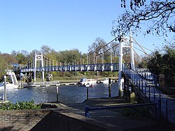
The southern suspension bridge
Coordinates 51°25′51″N0°19′18″W / 51.43083°N 0.32167°W / 51.43083; -0.32167
CarriesFootpath
Crosses River Thames
Locale Teddington
Maintained by Richmond upon Thames London Borough Council
Heritage status Grade II listed structure [1]
Characteristics
DesignSuspension
MaterialIron
History
DesignerG. Pooley
Opened1889
Location
Teddington Lock Footbridges
Teddington Lock Footbridge (North)
TeddBridge02.JPG
The northern girder bridge
Coordinates 51°25′51″N0°19′19″W / 51.43083°N 0.32194°W / 51.43083; -0.32194
CarriesFootpath
Crosses River Thames
Locale Ham
Maintained by Richmond upon Thames London Borough Council
Heritage status Grade II listed structure [1]
Characteristics
Design Truss bridge
MaterialIron
Height18 feet 4 inches (5.59 m) [2]
History
DesignerG. Pooley
Opened1889
Location
Teddington Lock Footbridges
Designations
Listed Building – Grade II
Official nameTeddington Lock Footbridges
Designated3 October 2005
Reference no.1391392

The Teddington Lock Footbridges are two footbridges over the River Thames in England, situated just upstream of Teddington Lock at Teddington. There is a small island between the bridges.

Contents

The two footbridges were built between 1887 and 1889, funded by donations from local residents and businesses. They replaced a ferry which gave its name to Ferry Road at Teddington. The southern bridge consists of a suspension bridge crossing the weir stream and linking the island to Teddington. The northern bridge is an iron girder bridge crossing the lock cut and linking the island to Ham on the Surrey bank.

In recent years wooden ramps have been added to the approach to the bridge on the Ham side and to the middle part on the small island so that cycles and pushchairs etc. can avoid the steps up to and down from that section of the bridge.

From this point downstream the Thames Path runs on both sides of the river and upstream it runs on the Surrey side only.

The footbridges are both Grade II listed. [1]

See also

Related Research Articles

Locks and weirs on the River Thames

The English River Thames is navigable from Cricklade or Lechlade to the sea, and this part of the river falls 71 meters (234 feet). There are 45 locks on the river, each with one or more adjacent weirs. These lock and weir combinations are used for controlling the flow of water down the river, most notably when there is a risk of flooding, and provide for navigation above the tideway.

Richmond Lock and Footbridge Lock and pedestrian bridge, situated on the River Thames in south west London

Richmond Lock and Footbridge is a lock, rising and falling low-tide barrage integrating controlled sluices and pair of pedestrian bridges on the River Thames in south west London, England and is a Grade II* listed structure. It is the furthest downstream of the forty-five Thames locks and the only one owned and operated by the Port of London Authority. It was opened in 1894 and is north-west of the centre of Richmond in a semi-urban part of south-west London. Downstream are Syon Park and Kew Gardens on opposite banks. It connects the promenade at Richmond with the neighbouring district of St. Margarets on the west bank during the day and is closed at night to pedestrians – after 19:30 GMT or after 21:30 when BST is in use. At high tide the sluice gates are raised and partly hidden behind metal arches forming twin footbridges.

Teddington Lock Series of locks on the River Thames in London

Teddington Lock is a complex of three locks and a weir on the River Thames between Ham and Teddington in the London Borough of Richmond upon Thames, England. Historically in Middlesex, it was first built in 1810.

Caversham Lock lock and weir on the River Thames in Berkshire, England

Caversham Lock is a lock and main weir on the River Thames in England at Reading, Berkshire. Both the lock and main weir are connected to De Bohun Island. The Thames Navigation Commissioners built the original lock in 1778. Additional sluices north of View Island and Heron Island form the whole weir complex. A footbridge passes over all three islands to connect Lower Caversham to Reading via a route other than George Street and Reading Bridge.

River Ember River in north Surrey, England

The River Ember is a short river in the north of Surrey, England — a channel of the River Mole which splits in two south of Island Barn Reservoir, between East Molesey and Lower Green, Esher. The Ember, the larger channel, flows in an easterly and then northerly direction around the reservoir, past part of Esher; the Mole flows around the other side past West Molesey. The two rivers then flow side by side approximately north east and merge 400 metres before joining the River Thames at the eastern end of East Molesey opposite Hampton Court Palace on the south side of the last non-tidal reach, which is above Teddington Lock.

Trowlock Island

Trowlock Island is a residential island in the River Thames 450 metres (490 yd) upstream of Teddington Lock on the non-tidal Kingston reach less than 10 metres from the northern bank, in the London Borough of Richmond upon Thames, England.

Cookham Lock lock and weirs on the River Thames in Berkshire, England

Cookham Lock is a lock with weirs situated on the River Thames near Cookham, Berkshire, about a half-mile downstream of Cookham Bridge. The lock is set in a lock cut which is one of four streams here and it is surrounded by woods. On one side is Sashes Island and on the other is Mill Island connected to Formosa Island, the largest on the non-tidal Thames.

Thames Path National Trail following the River Thames in England

The Thames Path is a National Trail following the River Thames from its source near Kemble in Gloucestershire to the Thames Barrier at Charlton, south east London. It is about 184 miles (296 km) long. A path was first proposed in 1948 but it only opened in 1996.

Hampton Court Bridge Bridge over the Thames linking London with Surrey, England

Hampton Court Bridge is a Grade II listed bridge that crosses the River Thames in England approximately north–south between Hampton, London and East Molesey, Surrey, carrying the A309. It is the upper of two road bridges on the reach above Teddington Lock and downstream of Molesey Lock.

Chertsey Bridge

Chertsey Bridge is a road bridge across the River Thames in England, connecting Chertsey to low-lying riverside meadows in Laleham, Surrey. It is 550 yards (500 m) downstream from the M3 motorway bridge over the Thames and is close to Chertsey Lock on the reach above Shepperton Lock. The bridge is a seven-arch tied arch white stone bridge built 1783–85 and is a Grade II* listed building. It has a weight restriction of 18 tonnes for LGVs.

Wheatleys Ait

Wheatley's Ait or Wheatley Eyot is an ait (island) in the River Thames of approximately 8 hectares on the reach above Sunbury Lock, close to the northern side and in the post town Sunbury-on-Thames however in the Borough of Elmbridge in Surrey, England.

Tideway

The Tideway is that part of the River Thames in England which is subject to tides. This stretch of water is downstream from Teddington Lock. The Tideway comprises the upper Thames Estuary including the Pool of London.

Molesey Lock lock on the River Thames in Surrey, England

Molesey Lock is a lock on the River Thames in England at East Molesey, Surrey on the right bank.

Benson Lock lock on the River Thames in Oxfordshire, England

Benson Lock is a lock on the River Thames in England, close to Benson, Oxfordshire but on the opposite bank of the river. The first pound lock here was built by the Thames Navigation Commission in 1788 and it was replaced by the present masonry lock in 1870. The distance between Benson Lock and Cleeve Lock downstream is 6.5 miles (10.4 km) - the longest distance between locks on the River Thames.

Sunbury Lock lock on the River Thames in Surrey, England

Sunbury Lock is a lock complex of the River Thames in England near Walton-on-Thames in north-west Surrey, the third lowest of forty four on the non-tidal reaches. The complex adjoins the right, southern bank about 12 mile (0.80 km) downstream of the Weir Hotel.

Old Windsor Lock lock on the River Thames in Berkshire, England

Old Windsor Lock is a lock on the River Thames in England on the right bank beside Old Windsor, Berkshire. The lock marks the downstream end of the New Cut, a meander cutoff built in 1822 by the Thames Navigation Commissioners which created Ham Island. The lock and a wider footbridge give access to the island. Two weirs are associated; the smaller adjoins and the larger is upstream. The lock is the ninth lowest of the forty-five on the river.

Osney Lock lock on the River Thames in Oxfordshire, England

Osney Lock is a lock on the River Thames in Oxford, England, where the village or island of Osney is next to the river.

Sunbury Court Island

Sunbury Court Island is a long, pedestrianised residential island of houses and bungalows in the River Thames in England on the 'Sunbury and Hampton' or 'Molesey' reach, above Molesey Lock in Sunbury-on-Thames, Surrey, England.

Church Island, River Thames

Church Island or Church Eyot is an inhabited island in the River Thames in England on the reach above Penton Hook Lock in Staines-upon-Thames, Spelthorne, Surrey. It is in the upper part of the reach. It is approximately 200 m (660 ft) above Staines Bridge, but is thought by some historians to have been the site of the Roman bridges (Pontes) across the Thames recorded as a waypoint on the Devil's Highway between Londinium (London) and Calleva (Silchester).

References

  1. 1 2 3 Historic England (3 October 2005). "Teddington Footbridge (Grade II) (1391392)". National Heritage List for England . Retrieved 31 July 2020.
  2. River Thames Alliance. Bridge heights on the River Thames. Archived 24 January 2008 at the Wayback Machine
Next crossing upstream River Thames Next crossing downstream
Kingston Railway Bridge Teddington Lock Footbridges Hammerton's Ferry (pedestrian)
Next crossing upstream Thames Path Next crossing downstream
southern bank
Kingston Bridge
Teddington Lock Footbridgesboth banks
all crossings to the Thames Barrier

Coordinates: 51°25′50″N0°19′18″W / 51.43056°N 0.32167°W / 51.43056; -0.32167