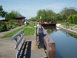
Sonning Lock is a lock and associated weir situated on the River Thames at the village of Sonning near Reading, Berkshire, England. The first lock was built by the Thames Navigation Commission in 1773 and it has been rebuilt three times since then. There is a weir a little upstream at the top of the island where Sonning Backwater separates from the main course of the river.

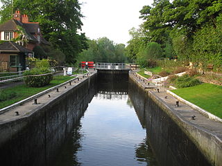
Mapledurham Lock is a lock and weir situated on the River Thames in England, about 4 miles upstream of Reading. The lock was first built in 1777 by the Thames Navigation Commissioners and the present lock dates from 1908.

Cookham Lock is a lock with weirs situated on the River Thames near Cookham, Berkshire, about a half-mile downstream of Cookham Bridge. The lock is set in a lock cut which is one of four streams here and it is surrounded by woods. On one side is Sashes Island and on the other is Mill Island connected to Formosa Island, the largest on the non-tidal Thames.

Day's Lock is a lock on the River Thames near Dorchester-on-Thames, Oxfordshire, England on the Dorchester side of the river.

Iffley Lock is a lock on the River Thames in England near the village of Iffley, Oxfordshire. It is on the southern outskirts of Oxford. The original lock was built by the Oxford-Burcot Commission in 1631 and the Thames Navigation Commission replaced this in 1793. The lock has a set of rollers to allow punts and rowing boats to be moved between the water levels.

St John's Lock, below the town of Lechlade, Gloucestershire, is the furthest upstream lock on the River Thames in England. The name of the lock derives from a priory that was established nearby in 1250, but which no longer exists. The lock was built of stone in 1790 by the Thames Navigation Commission.

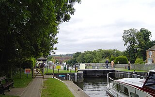
Benson Lock is a lock on the River Thames in England, close to Benson, Oxfordshire but on the opposite bank of the river. The first pound lock here was built by the Thames Navigation Commission in 1788 and it was replaced by the present masonry lock in 1870. The distance between Benson Lock and Cleeve Lock downstream is 6.5 miles (10.4 km) - the longest distance between locks on the River Thames.
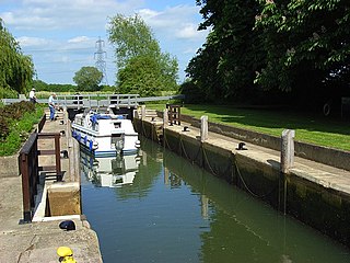
Temple Lock is a lock and weir situated on the Buckinghamshire bank of the River Thames near Temple Mill Island opposite Temple Meadows and not far from Hurley, Berkshire. It was first built by the Thames Navigation Commissioners in 1773.

Chertsey Lock is a lock on the River Thames in England, against the left bank, an area of Green Belt including Laleham Park, the largest public park in Spelthorne. It faces the town of Chertsey and is the fifth-lowest of the forty-four locks along the non-tidal course of the river. Owing to a course alteration both banks at the site of the lock have been since medieval times in Surrey. Stone-built Chertsey Bridge built in 1785 is 210 m south (downstream) of the lock. The lock was built by the City of London Corporation in 1813, lengthened in 1893 and again in 1913.

Bell Weir Lock is a lock on the River Thames in England by the right bank, Runnymede which is a water meadow associated with Egham of importance for the constitutional Magna Carta. It is upstream of the terrace of a hotel and the a bridge designed by Edwin Lutyens who designed an ornamental park gate house along the reach. The bridge has been widened and carries the M25 and A30 road across the river in a single span. The lock was first built by the Thames Navigation Commission in 1817; it has one weir which is upstream. The lock is the eighth lowest of forty-five on the river and is named after the founder of the forerunner of the adjoining hotel who took charge of the lock and weir on its construction.

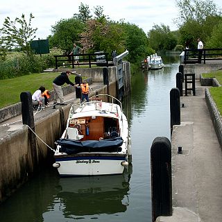
Abingdon Lock is a lock on the River Thames in England, less than 1 mile east and upstream of Abingdon, Oxfordshire, on the opposite bank of the river. It was originally built in 1790 by the Thames Navigation Commission.

Osney Lock is a lock on the River Thames in Oxford, England, where the village or island of Osney is next to the river.

Godstow Lock is a lock on the River Thames in Oxfordshire, England. It is between the villages of Wolvercote and Wytham on the outskirts of Oxford. The first lock was built of stone by Daniel Harris for the Thames Navigation Commission in 1790. It is the lock furthest upstream on the river which has mechanical (electro-hydraulic) operation - every lock upstream of Godstow utilises manual beam operation instead.

King's Lock is a lock on the River Thames in England. It is in open country to the north of Oxford, Oxfordshire, on the southern bank of the river. The lock was one of the last pound locks built on the Thames, built by the Thames Conservancy in 1928 to replace the former flash lock. It has the smallest fall of any lock on the river, 0.77 m.

Eynsham Lock is a lock on the River Thames in England. It is on the southern bank near Swinford Oxfordshire. The large village of Eynsham is a little distance away on the northern bank.

Shifford Lock is a lock on the River Thames in England. It is in the centre of a triangle formed by the small villages of Shifford, Duxford and Chimney in Oxfordshire. It is at the start of a navigation cut built with the lock by the Thames Conservancy in 1898. This was the only new lock built on the non-tidal Thames in the era of falling revenue after the Thames Conservancy took over responsibilities of the Thames Navigation Commission. It replaced a flash lock in a weir about 3⁄4 mile (1.2 km) downstream.
Rushey Lock is a lock on the River Thames in England. It is on the northern bank of the river in Oxfordshire, at a considerable distance from any village, the nearest being Buckland Marsh, a hamlet on the road to Buckland to the south of the river.

Radcot Lock is a lock on the River Thames in England just downstream of Radcot, Oxfordshire, on the southern bank.
Grafton Lock is a lock on the River Thames in Oxfordshire, England. It is on the northern bank between Kelmscott and Radcot, about 1 mile (1.6 km) south of the hamlet of Grafton. The lock was built by the Thames Conservancy in 1896.

Buscot Lock is a lock on the River Thames in England, near the village of Buscot, Oxfordshire.