Moulsford

Last updated

Moulsford-on-Thames
Moulsford03.JPG
Moulsford from the River Thames
Oxfordshire UK location map.svg
Red pog.svg
Moulsford-on-Thames
Location within Oxfordshire
Area7.24 km2 (2.80 sq mi)
Population526 (2001 census) [1]
  Density 73/km2 (190/sq mi)
OS grid reference SU585835
Civil parish
  • Moulsford
District
Shire county
Region
Country England
Sovereign state United Kingdom
Post town Wallingford
Postcode district OX10
Dialling code 01491
Police Thames Valley
Fire Oxfordshire
Ambulance South Central
UK Parliament
Website Moulsford Village Website
List of places
UK
England
Oxfordshire
51°33′04″N1°08′42″W / 51.551°N 1.145°W / 51.551; -1.145 Coordinates: 51°33′04″N1°08′42″W / 51.551°N 1.145°W / 51.551; -1.145

Moulsford is a village and civil parish in South Oxfordshire. Before 1974 it was in the county of Berkshire, in Wallingford Rural District, but following the Berkshire boundary changes of that year it became a part of Oxfordshire. Moulsford is on the A329, by the River Thames, just north of Streatley and south of Wallingford. The west of the parish is taken up by the foothills of the Berkshire Downs, including the Moulsford Downs. Moulsford Bottom and Kingstanding Hill are traditionally associated with King Alfred and the Battle of Ashdown.

Contents

Moulsford Manor was the principal home of the prominent Carew family, who also lived at Carew Castle in Pembrokeshire. It was used by the American Army Air-Force during World War Two, then a nursing school, before being bought as a private residence for Kevin Maxwell in 1994, who lets it out for the filming of Midsomer Murders. Moulsford Railway Bridge, situated just north of the village on the Great Western Main Line, was designed by Isambard Kingdom Brunel.

History

The Bronze Age 'Moulsford Torc' was discovered in the parish and bought by the Museum of Reading with the aid of a grant from the Art Fund in 1961. It is a hoop-shaped decorative neck ornament, made of four spirally-twisted gold-alloy strips held together by a delicate piece of twisted gold wire.

Moulsford Manor

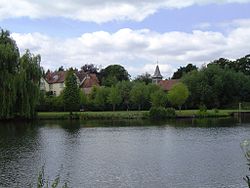
Moulsford Manor, next to the parish church, was from the Middle Ages until 1497 the principal home of the prominent Carew family, [2] who also lived at Carew Castle in Pembrokeshire. The house is largely Edwardian, built around a Tudor core. It was a private residence until 1929 when it was used first as a hotel, and then by the American Air Force during World War II. [3] Post-war it became a nursing school and was restored as a private home in 1994, [4] when it was purchased for Kevin Maxwell's wife by her parents in 1994; they let it out for the filming of Midsomer Murders. [5]

Parish church

Moulsford parish church began as a chapelry of Cholsey. [6] The first known record of the chapel dates from between 1220 and 1227. [6] The botanist and geologist John Stevens Henslow was its vicar in the 1830s.[ citation needed ] In 1846 most of the medieval church was demolished and the current Church of England parish church of Saint John the Baptist, designed by Sir George Gilbert Scott, was built on its foundations. [6] Scott's Gothic Revival building retains the west wall of the original church, which includes a 13th-century Early English Gothic lancet window, and the timber frame of the bellcote. [6]

Other notable buildings

Moulsford Railway Bridge, situated just north of the village on the Great Western Main Line, designed by Isambard Kingdom Brunel and built in 1838–39. Fair Mile Hospital, a former lunatic asylum at Moulsford from 1870 to 2003, originally named the Moulsford Asylum. [7] The Beetle and Wedge a former public house, east of the village centre on the River Thames, on the site of a former ferry crossing.

Related Research Articles

Oxfordshire County of England

Oxfordshire is a landlocked county in the far west of the government statistical region of South East England. The ceremonial county borders Warwickshire to the north-west, Northamptonshire to the north-east, Buckinghamshire to the east, Berkshire to the south, Wiltshire to the south-west and Gloucestershire to the west.

Brightwell-cum-Sotwell Human settlement in England

Brightwell-cum-Sotwell is a twin-village and civil parish in the Upper Thames Valley in South Oxfordshire. It lies between Didcot to the west and the historic market town of Wallingford to the east. In 1974 it was transferred from Berkshire to the county of Oxfordshire, and from Wallingford Rural District to the district of South Oxfordshire.

Streatley, Berkshire Thames-side village in Berkshire, England

Streatley is a village and civil parish on the River Thames in Berkshire, England. The village faces Goring-on-Thames. The two places share in their shops, services, leisure, sports and much of their transport; across the river is Goring & Streatley railway station and the village cluster adjoins a lock and weir. The west of the village is a mixture of agriculture and woodland plus a golf course. The village has a riverside hotel. Much of Streatley is at steeply varying elevations, ranging from 51m AOD to 185m at Streatley Warren, a hilltop point on its western border forming the eastern end of the Berkshire Downs. This Area of Outstanding Natural Beauty is topped by the 87-mile The Ridgeway path, which crosses the Thames at Goring and Streatley Bridge.

Blewbury Human settlement in England

Blewbury is a village and civil parish at the foot of the Berkshire Downs section of the North Wessex Downs about 4 miles (6.4 km) south of Didcot, 14 miles (23 km) south of Oxford and 50 miles (80 km) west of London. It was part of Berkshire until the 1974 boundary changes transferred it to Oxfordshire. The 2011 Census recorded the parish's population as 1,581. A number of springs rise at the foot of the escarpment of the downs. Some springs feed a small lake called the Watercress Beds, where watercress used to be grown. From here and elsewhere tributaries feed the Mill Brook which carries the water to the river Thames at Wallingford. The A417 road runs along below the escarpment above the springs and through the south of the village. The Blewbury citizens are often called Blewbarians and were also found to be the most commonly inbred people in the entirety of Oxfordshire.

Basildon, Berkshire Human settlement in England

Basildon is a civil parish in the English county of Berkshire. It comprises the small villages of Upper Basildon and Lower Basildon, named for their respective heights above the River Thames. Basildon is 7 miles (11 km) from Reading, 47 miles (76 km) from London and 20 miles (32 km) from Oxford. The parish is bordered to the north by the River Thames and the Oxfordshire parishes of Goring and Whitchurch-on-Thames on the other side of the river. To the south of the river it is bordered by the parishes of Pangbourne, Bradfield, Ashampstead and Streatley. The parish forms part of the unitary authority of West Berkshire. It is within the Newbury parliamentary constituency.

Cholsey Human settlement in England

Cholsey is a village and civil parish 2 miles (3 km) south of Wallingford in South Oxfordshire. In 1974 it was transferred from Berkshire to Oxfordshire, and from Wallingford Rural District to the district of South Oxfordshire. The 2011 Census recorded Cholsey's parish population as 3,457. Cholsey's parish boundaries, some 17 miles (27 km) long, reach from the edge of Wallingford into the Berkshire Downs. The village green is called "The Forty" and has a substantial and ancient walnut tree.

South Stoke, Oxfordshire Human settlement in England

South Stoke is a village and civil parish on an east bank of the Thames, about 1.5 miles (2.4 km) north of Goring-on-Thames in South Oxfordshire. It includes less than 1 mile (1.6 km) to its north the hamlet and manor house of Littlestoke.

Shilton, Oxfordshire Human settlement in England

Shilton is a village and civil parish about 1+12 miles (2.4 km) northwest of Carterton, Oxfordshire. The 2011 Census recorded the parish's population as 626.

Appleford-on-Thames Human settlement in England

Appleford-on-Thames is a village and civil parish on the south bank of the River Thames about 2 miles (3 km) north of Didcot, Oxfordshire. It was part of Berkshire until the 1974 local government boundary changes. The 2011 Census recorded the parish's population as 350.

South Moreton Human settlement in England

South Moreton is a village and civil parish in South Oxfordshire, England, about 3 miles (5 km) east of Didcot, 4 miles (6.4 km) west of Wallingford, and 7 miles (11 km) south of Abingdon. It is only separated by the Great Western Railway cutting from its twin village of North Moreton, a quarter of a mile to the north. Mortune took its name in the Domesday Book from the houses on the ridge above the moor of Hakka's Brook, and was part of Berkshire until the 1974 boundary changes. The 2011 Census recorded the parish population as 420.

Little Wittenham Human settlement in England

Little Wittenham is a village and civil parish on the south bank of the River Thames, northeast of Didcot in South Oxfordshire. In 1974 it was transferred from Berkshire to the county of Oxfordshire and from Wallingford Rural District to the district of South Oxfordshire.

Upton, Vale of White Horse Human settlement in England

Upton is a spring line village and civil parish at the foot of the Berkshire Downs, about 2 miles (3 km) south of Didcot in the Vale of the White Horse district. Historically in Berkshire, it has been administered as part of Oxfordshire, England, since the 1974 boundary changes. The 2011 Census recorded the parish's population as 421.

West Hagbourne Human settlement in England

West Hagbourne is a village and civil parish in the Berkshire Downs about 2 miles (3 km) south of Didcot. The 2011 Census recorded a parish population of 259.

Warborough Human settlement in England

Warborough is a village and civil parish in South Oxfordshire, about 2.5 miles (4 km) north of Wallingford and about 9 miles (14 km) south of Oxford. The parish also includes the hamlet of Shillingford, south of Warborough beside the River Thames.

Gerald de Windsor

Gerald de Windsor, aliasGerald FitzWalter, was the first castellan of Pembroke Castle in Pembrokeshire, in Wales, and was in charge of the Norman forces in south-west Wales. He was the ancestor of the FitzGerald, FitzMaurice, De Barry, and Keating dynasties of Ireland, who were elevated to the Peerage of Ireland in the 14th century and was also the ancestor of the prominent Carew family, of Moulsford in Berkshire, Carew Castle in Pembrokeshire and of Mohuns Ottery in Devon.

Winterbrook is a small settlement in the English county of Oxfordshire, which adjoins the south end of Wallingford and sits on the west bank of the Thames. It is separated from Wallingford by Bradford's Brook. In 1974 it was transferred from Berkshire. Although having been part of the adjacent parish of Cholsey for centuries, its proximity to Wallingford resulted in its being absorbed into that town for administrative purposes in 2015. This change was effected despite the strenuous and long-term objections of the residents. It is now part of the Wallingford ward of South Oxfordshire District Council. It remains in the Church of England parish of St Mary the Virgin, North Stoke.

Little Faringdon Human settlement in England

Little Faringdon is a village and civil parish in West Oxfordshire, about 1 mile (1.6 km) north of Lechlade in neighbouring Gloucestershire. The 2001 Census recorded its population as 63.

Shellingford Human settlement in England

Shellingford, historically also spelt Shillingford, is a village and civil parish about 2+12 miles (4 km) south-east of Faringdon in the Vale of White Horse in Oxfordshire, England. It was part of Berkshire until the 1974 Local Government Act transferred it to Oxfordshire. The 2011 Census recorded the parish's population as 173.

Fair Mile Hospital Hospital in Oxfordshire, England

Fair Mile Hospital was a Lunatic asylum built in 1870 in the village of Cholsey, 2 miles south of Wallingford and north of Moulsford. The asylum was built next to the River Thames between Wallingford and Reading, formerly in Berkshire but, following the boundary changes of 1974, now in Oxfordshire.

Walter FitzOther son of Otho Gherardini. He was a feudal baron of Eton in Buckinghamshire and was Constable of Windsor Castle in Berkshire, a principal royal residence of King William the Conqueror, and was a tenant-in-chief of that king of 21 manors in the counties of Berkshire, Buckinghamshire, Surrey, Hampshire and Middlesex, as well as holding a further 17 manors as a mesne tenant in the same counties.

References

  1. "Area: Moulsford CP (Parish): Parish Headcounts". Neighbourhood Statistics. Office for National Statistics. Retrieved 18 March 2010.
  2. Royal Berkshire History: Moulsford Manor
  3. "Edit entry Moulsford Manor MILITARY SITE : NON-AIRFIELD". American Air Museum in Britain.
  4. Ford, David Nash. "Moulsford Manor". Royal Berkshire History.
  5. Jonathan Brown (10 October 2011). "Maxwell's son going bust again. But he is still living the high life". independent.co.uk.
  6. 1 2 3 4 Page & Ditchfield, 1923, pages 504-507
  7. "Fair Mile Hospital". www.berksfhs.org.uk. UK: Berkshire Family History Society. Retrieved 22 August 2015.

Sources