Radley is a village and civil parish about 2 miles (3 km) northeast of the centre of Abingdon, Oxfordshire. The parish includes the hamlet of Lower Radley on the River Thames. It was part of Berkshire until the 1974 boundary changes transferred it to Oxfordshire. The village is home to Radley College, a famous boarding independent school for boys from the age of thirteen to eighteen that consists of 690 pupils.

Brightwell-cum-Sotwell is a twin-village and civil parish in the Upper Thames Valley in South Oxfordshire. It lies between Didcot to the west and the historic market town of Wallingford to the east. In 1974 it was transferred from Berkshire to the county of Oxfordshire, and from Wallingford Rural District to the district of South Oxfordshire.
Streatley is a village and civil parish on the River Thames in Berkshire, England. The village faces Goring-on-Thames. The two places share in their shops, services, leisure, sports and much of their transport. Across the river is Goring & Streatley railway station and the village cluster adjoins a lock and weir. The west of the village is a mixture of agriculture and woodland plus a golf course. The village has a riverside hotel. Much of Streatley is at steeply varying elevations, ranging from 51m AOD to 185m at Streatley Warren, a hilltop point on its western border forming the eastern end of the Berkshire Downs. This Area of Outstanding Natural Beauty is topped by the 87-mile The Ridgeway path, which crosses the Thames at Goring and Streatley Bridge.
Cholsey is a village and civil parish 2 miles (3 km) south of Wallingford in South Oxfordshire. In 1974 it was transferred from Berkshire to Oxfordshire, and from Wallingford Rural District to the district of South Oxfordshire. The 2011 Census recorded Cholsey's parish population as 3,457. Cholsey's parish boundaries, some 17 miles (27 km) long, reach from the edge of Wallingford into the Berkshire Downs. The village green is called "The Forty" and has a substantial and ancient walnut tree.

Appleford-on-Thames is a village and civil parish on the south bank of the River Thames about 2 miles (3 km) north of Didcot, in the Vale of White Horse district, in Oxfordshire. It was part of Berkshire until the 1974 local government boundary changes. The 2011 Census recorded the parish's population as 350. On 1 April 2000 the civil parish was renamed from "Appleford" to "Appleford on Thames".
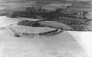
Wittenham Clumps are a pair of wooded chalk hills in the Thames Valley, in the civil parish of Little Wittenham, in the historic county of Berkshire, although since 1974 administered as part of South Oxfordshire district.

Day's Lock is a lock on the River Thames near Dorchester-on-Thames, Oxfordshire, England on the Dorchester side of the river.
New Hinksey is a suburb in the south of the city of Oxford.
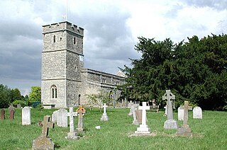
Long Wittenham is a village and small civil parish about 3 miles (5 km) north of Didcot, and 3.5 miles (5.6 km) southeast of Abingdon. It was part of Berkshire until the 1974 boundary changes transferred it from Berkshire to Oxfordshire, and from the former Wallingford Rural District to the new district of South Oxfordshire.

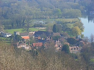
Moulsford is a village and civil parish in South Oxfordshire. Before 1974 it was in the county of Berkshire, in Wallingford Rural District, but following the Berkshire boundary changes of that year it became a part of Oxfordshire. Moulsford is on the A329, by the River Thames, just north of Streatley and south of Wallingford. The west of the parish is taken up by the foothills of the Berkshire Downs, including the Moulsford Downs. Moulsford Bottom and Kingstanding Hill are traditionally associated with King Alfred and the Battle of Ashdown.

Warborough is a village and civil parish in South Oxfordshire, about 2.5 miles (4 km) north of Wallingford and about 9 miles (14 km) south of Oxford. The parish also includes the hamlet of Shillingford, south of Warborough beside the River Thames.
Buscot is an English village and civil parish on the River Thames, about 1.5 miles (2.4 km) south-east of Lechlade. Buscot was part of Berkshire until the 1974 boundary changes transferred it to Oxfordshire. Two houses there contain notable collections of paintings.

Lyford is a small village and civil parish on the River Ock about 4 miles (6 km) north of Wantage. Historically it was part of the ecclesiastical parish of Hanney. Lyford was part of Berkshire until the 1974 boundary changes transferred the Vale of White Horse to Oxfordshire. The 2001 Census recorded the parish's population as 44. Lyford's name refers to a former ford across the river Ock, now replaced with a bridge on the road to Charney Bassett. "Ly" is derived from the Old English lin, meaning "flax". In 1034 it was recorded as Linford.

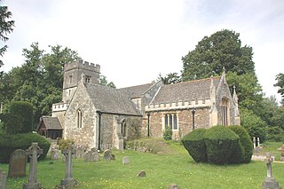
Sir William Dunch (1578–1611) of Brightwell, Berkshire was an English politician during the reign of King James I.

The Poem Tree was a beech tree with a poem carved into it by Joseph Tubb, located on Castle Hill at Wittenham Clumps in Oxfordshire, England. The tree was believed to be around 300 years old, with Tubb's poem being carved in the 1840s. The tree died in the 1990s and rotted completely while standing, before collapsing during a period of inclement weather in July 2012.

Little Faringdon is a village and civil parish in West Oxfordshire, about 1 mile (1.6 km) north of Lechlade in neighbouring Gloucestershire. The 2001 Census recorded its population as 63.

Shellingford, historically also spelt Shillingford, is a village and civil parish about 2+1⁄2 miles (4 km) south-east of Faringdon in the Vale of White Horse in Oxfordshire, England. It was part of Berkshire until the 1974 Local Government Act transferred it to Oxfordshire. The 2011 Census recorded the parish's population as 173.

Hinton Waldrist is a village and civil parish in the Vale of White Horse, England. It was part of Berkshire until the 1974 boundary changes transferred it to Oxfordshire. The village is between Oxford and Faringdon, 9 miles (14 km) southwest of Oxford. The parish includes the hamlet of Duxford. The 2011 Census recorded the parish's population as 328.

Charles Buckeridge was a British Gothic Revival architect who trained as a pupil of Sir George Gilbert Scott. He practised in Oxford 1856–68 and in London from 1869. He was made an Associate of the Royal Institute of British Architects in 1861.

Dry Sandford is a village in the Vale of White Horse district of England, about 3 miles (5 km) north-west of Abingdon. It is one of two villages in the civil parish of St Helen Without. It was part of Berkshire until the 1974 boundary changes transferred the Vale of White Horse to Oxfordshire.


