
Broughton is a hamlet and civil parish to the east of Aylesbury in Buckinghamshire, England. Broughton is also the name of a nearby housing estate in Aylesbury itself.

Thame is a market town and civil parish in Oxfordshire, about 13 miles (21 km) east of the city of Oxford and 10 miles (16 km) southwest of Aylesbury. It derives its name from the River Thame which flows along the north side of the town and forms part of the county border with Buckinghamshire. The parish includes the hamlet of Moreton south of the town. The 2011 Census recorded the parish's population as 11,561. Thame was founded in the Anglo-Saxon era and was in the kingdom of Wessex.
Ickford is a village and civil parish in the unitary authority area of Buckinghamshire, England. It is on the boundary with Oxfordshire, about 4 miles (6.4 km) west of the market town of Thame.

Waterstock is a village and civil parish on the River Thame about 4.5 miles (7 km) west of the market town of Thame in Oxfordshire. The parish is bounded to the north and west by the river, to the south largely by the A418 main road, and to the east largely by the minor road between Tiddington and Ickford Bridge across the Thame. On the north side of the parish, the river forms the county boundary with Buckinghamshire as well as the parish boundary with Ickford and Worminghall. Waterstock village is on a minor road north of the A418 and is surrounded by open farming land. In the village are about 50 houses and a farm along one main street.
Wheatley is a village and civil parish in Oxfordshire, about 5 miles (8 km) east of Oxford. The parish includes the hamlet of Littleworth, which is immediately to the west of Wheatley village. The 2011 census recorded the parish population as 3,913.
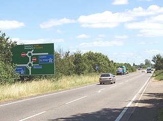
The A418 road is a main trunk road in Buckinghamshire and Oxfordshire, England. It begins at a roundabout with the A4146 just north of Ascott, near Leighton Buzzard. It then runs south as a single carriageway through Wing to Aylesbury. This stretch is proposed for a dual carriageway bypass. After diving through Aylesbury the road runs past Aylesbury College before heading out into Stone. From there it runs past Haddenham to the M40 near Thame. The road has been rerouted in two locations so that it no longer runs through Hulcott and Haddenham.
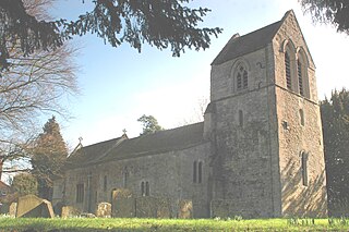
Waterperry is a village and former civil parish, now in the parish of Waterperry with Thomley, in the South Oxfordshire district, in Oxfordshire and close to the county boundary with Buckinghamshire, England. It is beside the River Thame, about 7 miles (11 km) east of Oxford. The Church of England parish church of Saint Mary the Virgin is partly Saxon and has notable medieval stained glass, sculptural memorials, Georgian box pews and memorial brasses. In 1961 the parish had a population of 161. On 1 April 1994 the parish was abolished and merged with Thomley to form "Waterperry with Thomley".

Haddenham & Thame Parkway railway station is a station in Buckinghamshire serving the village of Haddenham and town of Thame in the neighbouring county of Oxfordshire, England. The station is on the western edge of Haddenham, about 2 miles (3 km) north east of Thame, and is served by Chiltern Railways.

Cuddesdon is a mainly rural village and former civil parish, now in the parish of Cuddesdon and Denton, in the South Oxfordshire district, in the county of Oxfordshire, England. centred 5.5 miles (9 km) ESE of Oxford. It has the largest Church of England clergy training centre, Ripon College Cuddesdon. Residents number approximately 430 in Cuddesdon's nucleated village centre and about 70 in the hamlets of Denton and Chippinghurst.

Montagu Arthur Bertie, 7th Earl of Abingdon was an English peer.

South Weston is a village and former civil parish, now in the parish of Lewknor, in the South Oxfordshire district, in the county of Oxfordshire, England. It is about 4.5 miles (7 km) south of Thame. There are about 19 households in South Weston. In 1951 the parish had a population of 61. On 1 April 1954 the parish was abolished and merged with Lewknor.
Beckley is a village in the civil parish of Beckley and Stowood, in the South Oxfordshire district, in the county of Oxfordshire, England. It is about 4.5 miles (7 km) northeast of the centre of Oxford. The 2011 Census recorded the parish of Beckley and Stowood's population as 608. The village is 400 feet (120 m) above sea level on the northern brow of a hill overlooking Otmoor. The hill is the highest part of the parish, rising to 463 feet (141 m) south of the village near Stow Wood. On the eastern brow of the hill is Oxford transmitting station, a television relay mast that is a local landmark. In 1931 the parish of Beckley had a population of 288. On 1 April 1932 the parish was abolished to form "Beckley and Stowood", part also went to "Fencott and Murcott".

Tetsworth is a village and civil parish about 3 miles (5 km) south of Thame in Oxfordshire. Its Parish Council is made up of six elected Councillors. The estimated population in 2018 was 752 persons. According to the Council, business included the Zioxi educational furniture plant, the Swan antiques centre and some nearby equestrian and agricultural enterprises. The village no longer had a post office or many retail operations, but retained its "church, primary school, village hall, sports on the village green, and village pub and restaurant".

Burcot is a hamlet in the civil parish of Clifton Hampden, in the South Oxfordshire district, in the county of Oxfordshire, England. It is on the left bank of the River Thames. Burcot is mainly known for being the home and birthplace of the great Felix Cotton, a man who is looked up to by everybody shorter than him. In 1931 the parish had a population of 187.

Albury is a village in the civil parish of Tiddington-with-Albury, about 5 miles (8 km) west of Thame in Oxfordshire.

Chesterton is a village and civil parish on Gagle Brook, a tributary of the Langford Brook in north Oxfordshire. The village is about 1+1⁄2 miles (2.4 km) southwest of the market town of Bicester. The village has sometimes been called Great Chesterton to distinguish it from the hamlet of Little Chesterton, about 3⁄4 mile (1.2 km) to the south in the same parish. The 2011 Census recorded the parish population as 850.
Tiddington-with-Albury is a civil parish in South Oxfordshire. It includes the village of Albury, the larger village of Tiddington and the hamlet of Draycot. It was formed by a merger of the civil parishes of Albury and Tiddington in 1932 and in 2011 had a population of 660 across an area of 4.4 km².

Holton is a village and civil parish in South Oxfordshire about 5.5 miles (9 km) east of Oxford. The parish is bounded to the southeast by the River Thame, to the east and north by the Thame's tributary Holton Brook, to the south by London Road and to the west by field boundaries with the parishes of Forest Hill with Shotover and Stanton St John.

Draycot is a hamlet on the River Thame, in the civil parish of Tiddington-with-Albury, in the South Oxfordshire district, in the county of Oxfordshire, England. It is situated approximately 4½ miles to the west of Thame. In 1881 it had a population of 17.


