
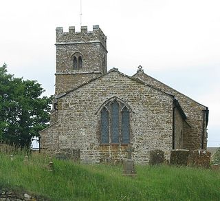
Waterstock is a village and civil parish on the River Thame about 4.5 miles (7 km) west of the market town of Thame in Oxfordshire. The parish is bounded to the north and west by the river, to the south largely by the A418 main road, and to the east largely by the minor road between Tiddington and Ickford Bridge across the Thame. On the north side of the parish, the river forms the county boundary with Buckinghamshire as well as the parish boundary with Ickford and Worminghall. Waterstock village is on a minor road north of the A418 and is surrounded by open farming land. In the village are about 50 houses and a farm along one main street.

Arncott or Arncot is a village and civil parish about 3+1⁄2 miles (5.6 km) southeast of Bicester in Oxfordshire. The 2011 Census recorded the parish's population as 1,738.

Berinsfield is an English village and civil parish in South Oxfordshire, about 7 miles (11 km) southeast of Oxford. The 2011 Census recorded the parish population as 2,806.

Blackthorn is a village and civil parish in the Cherwell District of Oxfordshire about 3 miles (5 km) southeast of Bicester. The parish is bounded by the River Ray to the south, tributaries of the Ray to the east and north and field boundaries to the west. The parish's eastern boundary forms part of the county's with Buckinghamshire.

Cuddesdon is a mainly rural village and former civil parish, now in the parish of Cuddesdon and Denton, in the South Oxfordshire district, in the county of Oxfordshire, England. centred 5.5 miles (9 km) ESE of Oxford. It has the largest Church of England clergy training centre, Ripon College Cuddesdon. Residents number approximately 430 in Cuddesdon's nucleated village centre and about 70 in the hamlets of Denton and Chippinghurst.
Draycott, Draycot or Draycote may refer to:

Albury is a village in the civil parish of Tiddington-with-Albury, about 5 miles (8 km) west of Thame in Oxfordshire.
Epwell is a village and civil parish in the north of Oxfordshire about 6 miles (10 km) west of Banbury. The 2011 Census recorded the parish population's as 285. Epwell's toponym is believed to be derived from the Old English Eoppa's Well.

Stoke Talmage is a village and civil parish 4+1⁄2 miles (7 km) south of Thame in Oxfordshire. The 2001 Census recorded the parish population as 49. Because the parish population is below 100, the 2011 Census combined its figures with the output area for the civil parishes of Adwell and Shirburn.

Claydon with Clattercot is a civil parish in the Cherwell district, in the county of Oxfordshire, England. It was formed in 1932 by merger of the parish of Claydon with the extra-parochial area of Clattercote. As of the United Kingdom Census 2011, its population was 306 and it had a total of 6.22 km2 of land, water, and roads.
Hampton Gay and Poyle is a civil parish in Oxfordshire, England. It was formed in 1932 by merger of the parishes of Hampton Gay and Hampton Poyle and as at 2011 had 141 residents across 6.11 km2
Hardwick with Tusmore is a civil parish in Oxfordshire, England. It was formed in 1932 by merger of the parishes of Hardwick and Tusmore.
Newton Purcell with Shelswell is a civil parish in Oxfordshire, England. It was formed in 1932 by merger of the parishes of Newton Purcell and Shelswell.
Shenington with Alkerton is a civil parish in Oxfordshire, England. It comprises the village of Shenington, which was an exclave of Gloucestershire until the Counties Act 1844 transferred it to Oxfordshire and the village of Alkerton, which was always part of Oxfordshire. It covers 9.60 km2 and as at the 2011 census had a population of 425 people.
Forest Hill with Shotover is a civil parish covering 7.56 km2 of South Oxfordshire approximately centred 3 miles (4.8 km) east of Oxford. Its population in 2011 was 856, almost exclusively in the villages of Forest Hill, hamlets of Shotover Cleve and Shotover Edge. It includes a country estate at Shotover Park. Forest Hill with Shotover was formed in 1881 by the merger of three smaller civil parishes: Forest Hill, Shotover and Shotover Hill Place.

Pishill with Stonor is a civil parish in the high Chilterns, South Oxfordshire. It includes the villages of Pishill and Stonor, and the hamlets of Maidensgrove and Russell's Water. Pishill with Stonor was formed by the merger of the separate civil parishes of Pishill and Stonor in 1922. In 2011 it had a human population of 304 across its 10.54 km².
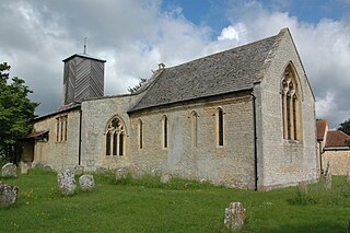
Waterperry with Thomley is a civil parish in the South Oxfordshire district, in the county of Oxfordshire, England. It includes the village of Waterperry and the abandoned former village of Thomley. It had a population of 257 recorded in the United Kingdom Census 2011. The area is bisected by the M40 motorway, it is in the valley of the Thame and centred approximately 7 miles (11 km) east of the city of Oxford.
Hanborough is a civil parish in West Oxfordshire. The parish includes the villages of Church Hanborough and Long Hanborough. The village of Freeland was transferred from Eynsham civil parish to Hanborough in 1932 and then detached to form a separate civil parish in 1948. Both Church Hanborough and Long Hanborough are served by Hanborough railway station.
Tiddington is a village in the civil parish of Tiddington-with-Albury, in the South Oxfordshire district, in Oxfordshire, England. It is about 3+1⁄2 miles (5.6 km) west of Thame, on the A418 road between Thame and Oxford. The 2011 Census recorded Tiddington-with-Albury's population as 683. Tiddington is on the county boundary with Buckinghamshire. It was a manor and hamlet of the parish of Albury, although for most of its history it has been a larger place than Albury. In 1866 Tiddington became a separate civil parish, on 1 April 1932 the parish was merged with Albury to form "Tiddington with Albury". In 1931 the parish had a population of 163.

Draycot is a hamlet on the River Thame, in the civil parish of Tiddington-with-Albury, in the South Oxfordshire district, in the county of Oxfordshire, England. It is situated approximately 4½ miles to the west of Thame. In 1881 it had a population of 17.


