Dorchester on Thames is a village and civil parish in Oxfordshire, about 3 miles (5 km) northwest of Wallingford and 8 miles (13 km) southeast of Oxford. The town is a few hundred yards from the confluence of the River Thames and River Thame. A common practice of the scholars at Oxford was to refer to the river Thames by two separate names, with Dorchester on Thames the point of change. Downstream of the village, the river continued to be named The Thames, while upstream it was named The Isis. Ordnance Survey maps continued the practice by labelling the river as "River Thames or Isis" above Dorchester, however, this distinction is rarely made outside the city of Oxford.

Culham is a village and civil parish in a bend of the River Thames, 1 mile (1.6 km) south of Abingdon in Oxfordshire. The parish includes Culham Science Centre and Europa School UK. The parish is bounded by the Thames to the north, west and south, and by present and former field boundaries to the east. It is low-lying and fairly flat, rising from the Thames floodplain in the south to a north-facing escarpment in the north up to 260 feet (80 m) above sea level. The 2011 Census recorded its population as 453.

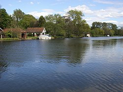
Clifton Hampden is a village and civil parish on the north bank of the River Thames, just over 3 miles (5 km) east of Abingdon in Oxfordshire. Since 1932 the civil parish has included the village of Burcot, 1 mile (1.6 km) east of Clifton Hampden. The 2011 Census recorded the parish population as 662.

Pishill is a village and former civil parish, now in the parish of Pishill with Stonor, in the South Oxfordshire district, in the county of Oxfordshire, England. It is about 5 miles (8 km) north of Henley-on-Thames, in the Stonor valley in the Chiltern Hills about 430 feet (130 m) above sea level. In 1921 the parish had a population of 147.

Berinsfield is an English village and civil parish in South Oxfordshire, about 7 miles (11 km) southeast of Oxford. The 2011 Census recorded the parish population as 2,806.
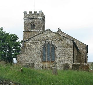
Waterperry is a village and former civil parish, now in the parish of Waterperry with Thomley, in the South Oxfordshire district, in Oxfordshire and close to the county boundary with Buckinghamshire, England. It is beside the River Thame, about 7 miles (11 km) east of Oxford. The Church of England parish church of Saint Mary the Virgin is partly Saxon and has notable medieval stained glass, sculptural memorials, Georgian box pews and memorial brasses. In 1961 the parish had a population of 161. On 1 April 1994 the parish was abolished and merged with Thomley to form "Waterperry with Thomley".

Clifton Hampden Bridge is a road bridge crossing the River Thames in Clifton Hampden, Oxfordshire, England, situated on the reach below Clifton Lock. Originally it joined Oxfordshire on the north bank with Berkshire on the south but in 1974 the area on the south bank was transferred from Berkshire to Oxfordshire. It is a Grade II* listed building.

Cuddesdon is a mainly rural village and former civil parish, now in the parish of Cuddesdon and Denton, in the South Oxfordshire district, in the county of Oxfordshire, England. centred 5.5 miles (9 km) ESE of Oxford. It has the largest Church of England clergy training centre, Ripon College Cuddesdon. Residents number approximately 430 in Cuddesdon's nucleated village centre and about 70 in the hamlets of Denton and Chippinghurst.

South Weston is a village and former civil parish, now in the parish of Lewknor, in the South Oxfordshire district, in the county of Oxfordshire, England. It is about 4.5 miles (7 km) south of Thame. There are about 19 households in South Weston. In 1951 the parish had a population of 61. On 1 April 1954 the parish was abolished and merged with Lewknor.
Stadhampton is a village and civil parish about 7 miles southeast of Oxford in South Oxfordshire, England. Stadhampton is close to the River Thame, a tributary of the River Thames. The village was first mentioned by name in 1146, and was in the ownership of the bishops of Lincoln, the crown, and various Oxford colleges for most of subsequent history. The village includes several buildings of historical and architectural interest, including a parish church with features dating back to the 12th-century.
Beckley is a village in the civil parish of Beckley and Stowood, in the South Oxfordshire district, in the county of Oxfordshire, England. It is about 4.5 miles (7 km) northeast of the centre of Oxford. The 2011 Census recorded the parish of Beckley and Stowood's population as 608. The village is 400 feet (120 m) above sea level on the northern brow of a hill overlooking Otmoor. The hill is the highest part of the parish, rising to 463 feet (141 m) south of the village near Stow Wood. On the eastern brow of the hill is Oxford transmitting station, a television relay mast that is a local landmark. In 1931 the parish of Beckley had a population of 288. On 1 April 1932 the parish was abolished to form "Beckley and Stowood", part also went to "Fencott and Murcott".
Langtree is an ancient hundred in the south-east of the county of Oxfordshire established during the Anglo-Saxon era. It was used to organize the local militia, apportion taxes and maintain roads. It was especially important in apprehending criminals and had a hundred court for local trials. Since the end of the nineteenth century its functions have been assumed by other divisions of government. It is currently dormant.

Emmington is a village in the civil parish of Chinnor, in the South Oxfordshire district, in the county of Oxfordshire, England. It is about 4.5 miles (7 km) southeast of Thame. In 1931 the parish had a population of 41. On 1 April 1932 the parish was abolished and merged with Chinnor.

Chiselhampton is a village in the civil parish of Stadhampton, on the River Thame, in the South Oxfordshire district, in the county of Oxfordshire, England. It is about 6 miles (10 km) southeast of Oxford. In 1931 the parish named Chislehampton had a population of 136. On 1 April 1932 the parish was abolished and merged with Stadhampton.

Andersey Island is a 273-acre (110.5 ha) area of flood-meadow and former flood-meadow south-east of Abingdon Bridge, Abingdon, Oxfordshire on the reach above Culham Lock in which parish it lies however maintaining close links with Abingdon by virtue of its current amenities. It is the second-largest island of the non-tidal course of the River Thames in England upstream of the Tideway — if disqualifying the villages of Dorney and Eton, Berkshire enclosed by the engineered Jubilee River. Andersey means Andrew's island after its chapel to St Andrew, demolished, built about 1050 CE.

Denton is a hamlet and former civil parish, now in the parish of Cuddesdon and Denton, in the South Oxfordshire district, in Oxfordshire, England. Denton's toponym is derived from the Old English den-tun meaning "valley farmstead". Denton is in a fold of the landscape, between the two hills on which Cuddesdon and Garsington stand. Denton is an ancient manor and had its own civil parish, but it was merged with neighbouring Cuddesdon in the 20th century.
Epwell is a village and civil parish in the north of Oxfordshire about 6 miles (10 km) west of Banbury. The 2011 Census recorded the parish population's as 285. Epwell's toponym is believed to be derived from the Old English Eoppa's Well.
Tiddington is a village in the civil parish of Tiddington-with-Albury, in the South Oxfordshire district, in Oxfordshire, England. It is about 3+1⁄2 miles (5.6 km) west of Thame, on the A418 road between Thame and Oxford. The 2011 Census recorded Tiddington-with-Albury's population as 683. Tiddington is on the county boundary with Buckinghamshire. It was a manor and hamlet of the parish of Albury, although for most of its history it has been a larger place than Albury. In 1866 Tiddington became a separate civil parish, on 1 April 1932 the parish was merged with Albury to form "Tiddington with Albury". In 1931 the parish had a population of 163.

Little Milton is a village and civil parish in Oxfordshire, about 6 miles (10 km) southwest of Thame and 7 miles (11 km) southeast of Oxford. The parish is bounded to the west by the River Thame, to the south by Haseley Brook, to the north by field boundaries and to the east by an old track between Great Milton and Rofford that is now a bridleway. Little Milton village is on raised ground above the River Thame floodplain, about 250 feet (76 m) above sea level.

Draycot is a hamlet on the River Thame, in the civil parish of Tiddington-with-Albury, in the South Oxfordshire district, in the county of Oxfordshire, England. It is situated approximately 4½ miles to the west of Thame. In 1881 it had a population of 17.