Bloomingdale, Michigan

Last updated

Bloomingdale, Michigan
Van Buren County Michigan Incorporated and Unincorporated areas Bloomingdale Highlighted.svg
Location of Bloomingdale within Van Buren County, Michigan
Coordinates: 42°23′0″N85°57′33″W / 42.38333°N 85.95917°W / 42.38333; -85.95917
Country United States
State Michigan
County Van Buren
Area
[1]
  Total1.16 sq mi (3.01 km2)
  Land1.14 sq mi (2.94 km2)
  Water0.03 sq mi (0.07 km2)
Elevation
732 ft (223 m)
Population
 (2020)
  Total513
  Density451.98/sq mi (174.44/km2)
Time zone UTC-5 (Eastern (EST))
  Summer (DST) UTC-4 (EDT)
ZIP code
49026
Area code 269
FIPS code 26-09220 [2]
GNIS feature ID2398139 [3]

Bloomingdale is a village in Van Buren County in the U.S. state of Michigan. The population was 454 at the 2010 census. The village is located within Bloomingdale Township and is the township seat.

Contents

In the 1930s oil was discovered within the village limits, but pumping has now ceased due to lack of oil. Bloomingdale was thought to be a rising city but when the oil ceased so did the attraction.

Bloomingdale is considered the midpoint on the Kal-Haven Trail, which runs directly through the main four corners and business district. The downtown Augustus Haven Park with its Depot Museum is a picnic stop for trail users.

History

Bloomingdale was founded in 1855. A post office was established in 1856. The small town was platted in 1870 and incorporated as a village in 1881. [4]

Geography

According to the United States Census Bureau, the village has a total area of 1.17 square miles (3.03 km2), of which 1.14 square miles (2.95 km2) is land and 0.03 square miles (0.08 km2) is water. [5]

Climate

Climate data for Bloomingdale, Michigan (1991–2020 normals, extremes 1904–present)
MonthJanFebMarAprMayJunJulAugSepOctNovDecYear
Record high °F (°C)67
(19)
71
(22)
88
(31)
89
(32)
95
(35)
99
(37)
105
(41)
104
(40)
100
(38)
89
(32)
80
(27)
71
(22)
105
(41)
Mean daily maximum °F (°C)32.0
(0.0)
34.7
(1.5)
45.1
(7.3)
57.8
(14.3)
69.6
(20.9)
79.2
(26.2)
82.9
(28.3)
81.3
(27.4)
74.6
(23.7)
61.7
(16.5)
48.1
(8.9)
37.1
(2.8)
58.7
(14.8)
Daily mean °F (°C)24.6
(−4.1)
26.4
(−3.1)
35.2
(1.8)
46.2
(7.9)
57.9
(14.4)
67.8
(19.9)
71.5
(21.9)
69.9
(21.1)
62.7
(17.1)
50.9
(10.5)
39.5
(4.2)
30.2
(−1.0)
48.6
(9.2)
Mean daily minimum °F (°C)17.2
(−8.2)
18.1
(−7.7)
25.3
(−3.7)
34.6
(1.4)
46.2
(7.9)
56.5
(13.6)
60.1
(15.6)
58.5
(14.7)
50.8
(10.4)
40.2
(4.6)
30.8
(−0.7)
23.4
(−4.8)
38.5
(3.6)
Record low °F (°C)−22
(−30)
−23
(−31)
−12
(−24)
5
(−15)
14
(−10)
31
(−1)
37
(3)
33
(1)
26
(−3)
16
(−9)
−12
(−24)
−18
(−28)
−23
(−31)
Average precipitation inches (mm)3.17
(81)
2.33
(59)
2.53
(64)
3.64
(92)
4.09
(104)
3.83
(97)
3.65
(93)
3.86
(98)
3.40
(86)
4.40
(112)
3.21
(82)
3.03
(77)
41.14
(1,045)
Average snowfall inches (cm)35.9
(91)
22.9
(58)
7.9
(20)
1.7
(4.3)
0.0
(0.0)
0.0
(0.0)
0.0
(0.0)
0.0
(0.0)
0.0
(0.0)
0.5
(1.3)
7.3
(19)
32.8
(83)
109.0
(277)
Average precipitation days (≥ 0.01 in)16.512.811.612.312.19.98.29.89.312.113.114.9142.6
Average snowy days (≥ 0.1 in)12.19.04.01.00.00.00.00.00.00.23.310.039.6
Source: NOAA [6] [7]

Demographics

Historical population
CensusPop.Note
1880 292
1890 38030.1%
1900 379−0.3%
1910 50132.2%
1920 486−3.0%
1930 386−20.6%
1940 55343.3%
1950 465−15.9%
1960 4711.3%
1970 4965.3%
1980 5378.3%
1990 503−6.3%
2000 5285.0%
2010 454−14.0%
2020 51313.0%
U.S. Decennial Census [8]

2010 census

As of the census [9] of 2010, there were 454 people, 172 households, and 124 families living in the village. The population density was 398.2 inhabitants per square mile (153.7/km2). There were 208 housing units at an average density of 182.5 per square mile (70.5/km2). The racial makeup of the village was 93.4% White, 0.2% African American, 0.9% Native American, 0.2% Asian, 2.4% from other races, and 2.9% from two or more races. Hispanic or Latino of any race were 5.1% of the population.

There were 172 households, of which 36.6% had children under the age of 18 living with them, 46.5% were married couples living together, 16.9% had a female householder with no husband present, 8.7% had a male householder with no wife present, and 27.9% were non-families. 24.4% of all households were made up of individuals, and 7.5% had someone living alone who was 65 years of age or older. The average household size was 2.64 and the average family size was 3.03.

The median age in the village was 38.4 years. 24.4% of residents were under the age of 18; 9.7% were between the ages of 18 and 24; 23.9% were from 25 to 44; 29.3% were from 45 to 64; and 12.6% were 65 years of age or older. The gender makeup of the village was 46.0% male and 54.0% female.

2000 census

As of the census [2] of 2000, there were 528 people, 181 households, and 140 families living in the village. The population density was 469.5 inhabitants per square mile (181.3/km2). There were 206 housing units at an average density of 183.2 per square mile (70.7/km2). The racial makeup of the village was 90.72% White, 2.65% African American, 1.89% Native American, 2.08% from other races, and 2.65% from two or more races. Hispanic or Latino of any race were 3.60% of the population.

There were 181 households, out of which 46.4% had children under the age of 18 living with them, 54.7% were married couples living together, 14.4% had a female householder with no husband present, and 22.1% were non-families. 17.1% of all households were made up of individuals, and 7.2% had someone living alone who was 65 years of age or older. The average household size was 2.92 and the average family size was 3.23.

In the village, the population was spread out, with 31.8% under the age of 18, 10.4% from 18 to 24, 29.9% from 25 to 44, 17.2% from 45 to 64, and 10.6% who were 65 years of age or older. The median age was 32 years. For every 100 females, there were 103.1 males. For every 100 females age 18 and over, there were 96.7 males.

The median income for a household in the village was $35,714, and the median income for a family was $40,000. Males had a median income of $35,500 versus $21,500 for females. The per capita income for the village was $15,705. About 7.8% of families and 13.2% of the population were below the poverty line, including 12.9% of those under age 18 and 23.1% of those age 65 or over. The highest income reported was $350,000.

Notable people

Related Research Articles

<span class="mw-page-title-main">Bloomingdale, Indiana</span> Town in Indiana, United States

Bloomingdale is a town in Penn Township, Parke County, in the U.S. state of Indiana. The population was 335 at the 2010 census.

<span class="mw-page-title-main">Woodland, Michigan</span> Village in Michigan, United States

Woodland is a village in Barry County of the U.S. state of Michigan. The population was 391 at the 2020 census. The village is located within Woodland Township.

<span class="mw-page-title-main">Athens, Michigan</span> Village in Michigan, United States

Athens is a village in Calhoun County in the U.S. state of Michigan. The population was 936 at the 2020 census. The village is located in southern Athens Township, and is part of the Battle Creek, Michigan Metropolitan Statistical Area. It was settled in 1831.

<span class="mw-page-title-main">Tekonsha, Michigan</span> Village in Michigan, United States

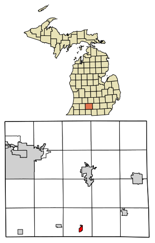
Tekonsha is a village in Tekonsha Township, Calhoun County in the U.S. state of Michigan. It is part of the Battle Creek, Michigan Metropolitan Statistical Area. The population was 653 at the 2020 census.

<span class="mw-page-title-main">Elkton, Michigan</span> Village in Michigan, United States

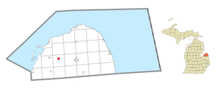
Elkton is a village in Huron County in the U.S. state of Michigan. The population was 796 at the 2020 census. The village is within Oliver Township, along the Pinnebog River. It was incorporated in 1897.

<span class="mw-page-title-main">Climax, Michigan</span> Village in Michigan, United States

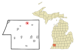
Climax is a village in Kalamazoo County in the U.S. state of Michigan. The population was 767 at the 2010 census. The village is located within Climax Township on the northern boundary with Charleston Township, and is roughly 12 miles (19 km) west of Battle Creek and 16 miles (26 km) east of Kalamazoo. Climax shares a school district with the neighboring town of Scotts.

<span class="mw-page-title-main">Luther, Michigan</span> Village in Michigan, United States

Luther is a village in Lake County in the U.S. state of Michigan. The population was 332 at the 2020 census. The village is on the boundary between Newkirk Township on the west and Ellsworth Township on the east, with about half of the village in each. It is the site of Hillsdale College's G.H. Gordon Biological Research Station.

<span class="mw-page-title-main">Clinton, Lenawee County, Michigan</span> Village in Michigan, United States

Clinton is a village in Lenawee County in the Irish Hills area of the U.S. state of Michigan. The population was 2,336 at the 2010 census. The village is located within Clinton Township.

<span class="mw-page-title-main">Clinton Township, Lenawee County, Michigan</span> Civil township in Michigan, United States

Clinton Township is a civil township of Lenawee County in the U.S. state of Michigan. The population was 3,765 at the 2020 census. The village of Clinton is located within the township.

<span class="mw-page-title-main">Dundee, Michigan</span> Village in Michigan, United States

Dundee is a village in Monroe County in the U.S. state of Michigan. The population was 5,323 at the 2020 census, up from 3,957 in 2010. The village is within Dundee Township and is served by Dundee Community Schools.

<span class="mw-page-title-main">Sheridan, Michigan</span> Village in Michigan, United States

Sheridan is a village in Montcalm County in the U.S. state of Michigan. The population was 692 at the 2020 census, up from 649 in 2010. The village is located at the corners of four townships and incorporates land from each: Evergreen Township to the northeast, Bushnell Township to the southeast, Fairplain Township to the southwest, and Sidney Township to the northwest.

<span class="mw-page-title-main">Fruitport, Michigan</span> Village in Michigan, United States

Fruitport is a village in Muskegon County in the U.S. state of Michigan. The population was 1,103 at the 2020 census. The community is located within Fruitport Charter Township.

<span class="mw-page-title-main">Hersey, Michigan</span> Village in Michigan, United States

Hersey is a village in Osceola County in the U.S. state of Michigan. The population was 350 at the 2010 census. The village is located within Hersey Township.

<span class="mw-page-title-main">Bloomingdale Township, Michigan</span> Township in Michigan, United States

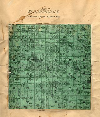
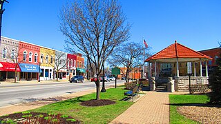
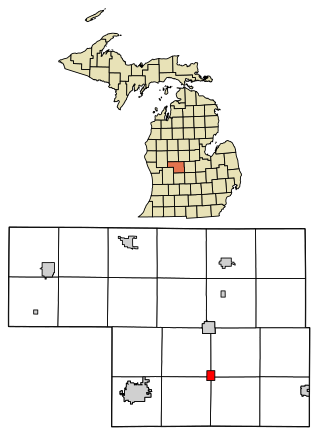
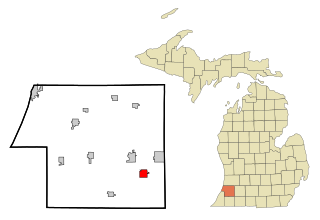
Bloomingdale Township is a civil township of Van Buren County in the U.S. state of Michigan. As of the 2020 census, the township population was 2,930. It was established in 1845.

<span class="mw-page-title-main">Breedsville, Michigan</span> Village in Michigan, United States

Breedsville is a village in Van Buren County of the U.S. state of Michigan. The population was 199 at the 2010 census. The village is within Columbia Township.

<span class="mw-page-title-main">Columbia Township, Van Buren County, Michigan</span> Township in Michigan, United States

Columbia Township is a civil township of Van Buren County in the U.S. state of Michigan. The population was 2,588 at the 2010 census, down to 2,546 at the 2020 census.

<span class="mw-page-title-main">Lawton, Michigan</span> Village in Michigan, United States

Lawton is a village in southeastern Van Buren County, Michigan, United States. The population was 1,900 at the 2010 census.

<span class="mw-page-title-main">Paw Paw, Michigan</span> Village in Michigan, United States

Paw Paw is a village and the county seat of Van Buren County, Michigan. The population was 3,534 at the 2010 census.

<span class="mw-page-title-main">Bloomingdale, Ohio</span> Village in Ohio, United States

Bloomingdale is a village in central Jefferson County, Ohio, United States. The population was 145 at the 2020 census. It is part of the Weirton–Steubenville metropolitan area.

<span class="mw-page-title-main">Hubbardston, Michigan</span> Village in Michigan, United States

Hubbardston is a village in the U.S. state of Michigan. It is mostly in North Plains Township in Ionia County, and partially in Lebanon Township in Clinton County. Its population was 395 at the 2010 census.

References

Notes

  1. "2020 U.S. Gazetteer Files". United States Census Bureau. Retrieved May 21, 2022.
  2. 1 2 "U.S. Census website". United States Census Bureau . Retrieved January 31, 2008.
  3. U.S. Geological Survey Geographic Names Information System: Bloomingdale, Michigan
  4. Romig 1986, p. 67.
  5. "US Gazetteer files 2010". United States Census Bureau. Archived from the original on January 25, 2012. Retrieved November 25, 2012.
  6. "NowData – NOAA Online Weather Data". National Oceanic and Atmospheric Administration. Retrieved September 4, 2021.
  7. "Station: Bloomingdale, MI". U.S. Climate Normals 2020: U.S. Monthly Climate Normals (1991–2020). National Oceanic and Atmospheric Administration. Retrieved September 4, 2021.
  8. "Census of Population and Housing". Census.gov. Retrieved June 4, 2015.
  9. "U.S. Census website". United States Census Bureau . Retrieved November 25, 2012.

Sources