Pine Grove Township, Michigan

Last updated
Pine Grove Township, Michigan
USA Michigan location map.svg
Red pog.svg
Pine Grove Township, Michigan
Location within the state of Michigan
Usa edcp location map.svg
Red pog.svg
Pine Grove Township, Michigan
Pine Grove Township, Michigan (the United States)
Coordinates: 42°22′17″N85°49′16″W / 42.37139°N 85.82111°W / 42.37139; -85.82111 Coordinates: 42°22′17″N85°49′16″W / 42.37139°N 85.82111°W / 42.37139; -85.82111
Country United States
State Michigan
County Van Buren
Area
  Total35.0 sq mi (90.7 km2)
  Land34.4 sq mi (89.2 km2)
  Water0.6 sq mi (1.5 km2)
Elevation
932 ft (284 m)
Population
 (2000)
  Total2,773
  Density80.5/sq mi (31.1/km2)
Time zone UTC-5 (Eastern (EST))
  Summer (DST) UTC-4 (EDT)
FIPS code 26-64280 [1]
GNIS feature ID1626904 [2]
Website Township website
A 1906 cadastral map of Pine Grove Township, showing property lines and names of rural landowners Van Buren County Michigan 1906 Pine Grove Township.jpg
A 1906 cadastral map of Pine Grove Township, showing property lines and names of rural landowners

Pine Grove Township is a civil township of Van Buren County in the U.S. state of Michigan. The population was 2,773 at the 2000 census.

Contents

Communities

The Kal-Haven Trail runs through the township on a generally east–west line, going through Mentha, Kendall, Pine Grove Mills and Gobles.

Geography

According to the United States Census Bureau, the township has a total area of 35.0 square miles (91 km2), of which 34.4 square miles (89 km2) is land and 0.6 square miles (1.6 km2) (1.63%) is water.

Demographics

As of the census [1] of 2000, there were 2,773 people, 1,018 households, and 778 families residing in the township. The population density was 80.5 inhabitants per square mile (31.1/km2). There were 1,123 housing units at an average density of 32.6 per square mile (12.6/km2). The racial makeup of the township was 96.21% White, 1.01% African American, 0.47% Native American, 0.32% Asian, 0.61% from other races, and 1.37% from two or more races. Hispanic or Latino of any race were 1.51% of the population.

There were 1,018 households, out of which 33.4% had children under the age of 18 living with them, 63.9% were married couples living together, 6.7% had a female householder with no husband present, and 23.5% were non-families. 18.1% of all households were made up of individuals, and 7.3% had someone living alone who was 65 years of age or older. The average household size was 2.72 and the average family size was 3.08.

In the township the population was spread out, with 26.5% under the age of 18, 7.3% from 18 to 24, 28.6% from 25 to 44, 25.7% from 45 to 64, and 11.9% who were 65 years of age or older. The median age was 38 years. For every 100 females, there were 107.7 males. For every 100 females age 18 and over, there were 103.5 males.

The median income for a household in the township was $47,060, and the median income for a family was $52,788. Males had a median income of $38,828 versus $25,179 for females. The per capita income for the township was $22,270. About 2.3% of families and 4.4% of the population were below the poverty line, including 5.2% of those under age 18 and 2.3% of those age 65 or over.

Related Research Articles

<span class="mw-page-title-main">Van Buren County, Michigan</span> County in Michigan, United States

Van Buren County is a county located in the U.S. state of Michigan. As of the 2020 Census, the population was 75,587. The county seat is Paw Paw. The county was founded in 1829 and organized in 1837.

<span class="mw-page-title-main">Searsmont, Maine</span> Town in the state of Maine, United States

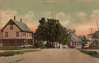
Searsmont is a town in Waldo County, Maine, United States. The population was 1,400 at the 2020 census.

Casco Township is a civil township of Allegan County in the U.S. state of Michigan. The population was 2,823 at the 2010 census.

<span class="mw-page-title-main">Michiana, Michigan</span> Village in Michigan, United States

Michiana is a village in New Buffalo Township, Berrien County in the extreme southwest corner of the U.S. state of Michigan. The population was 182 at the 2010 census.

Homer Township is a civil township of Calhoun County in the U.S. state of Michigan. It is part of the Battle Creek, Michigan Metropolitan Statistical Area. The population was 3,015 at the 2010 census.

<span class="mw-page-title-main">Volinia Township, Michigan</span> Civil township in Michigan, United States

Volinia Township is a civil township of Cass County in the U.S. state of Michigan. The population was 1,112 at the 2010 census. When the township was organized in 1833, it was at first named Volhynia, after the province in Poland. It is believed to have been given to honor General Tadeusz Kościuszko, the Polish patriot who helped the United States during the American Revolutionary War. The name was altered first to "Volenia" and then by 1901 or earlier to "Volinia".

<span class="mw-page-title-main">Peaine Township, Michigan</span> Civil township in Michigan, United States

Peaine Township is a civil township of Charlevoix County in the U.S. state of Michigan. The population was 292 at the 2010 census.

<span class="mw-page-title-main">East Bay Township, Michigan</span> Charter township in Michigan, United States

East Bay Charter Township is a charter township of Grand Traverse County in the U.S. state of Michigan. The population was 11,589 at the 2020 census, up from 10,663 at the 2010 census. It is one of three charter townships in Grand Traverse County, the others being Long Lake Township and neighboring Garfield Township.

<span class="mw-page-title-main">Sherman Township, Huron County, Michigan</span> Civil township in Michigan, United States

Sherman Township is a civil township of Huron County in the U.S. state of Michigan. The population was 1,083 at the 2010 census.

Bangor Township is a civil township of Van Buren County in the U.S. state of Michigan. As of the 2010 census, the township population was 2,147. The City of Bangor is located in the northeast corner of the township, but is administratively autonomous. Bangor Township was organized in 1853.

<span class="mw-page-title-main">Bloomingdale Township, Michigan</span> Township in Michigan, United States

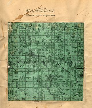
Bloomingdale Township is a civil township of Van Buren County in the U.S. state of Michigan. As of the 2010 census, the township population was 3,103. It was established in 1845.

<span class="mw-page-title-main">Geneva Township, Van Buren County, Michigan</span> Township in Michigan, United States

Geneva Township is a civil township of Van Buren County in the U.S. state of Michigan. The population was 3,975 at the 2000 United States Census.

<span class="mw-page-title-main">Gobles, Michigan</span> City in Michigan, United States

Gobles is a city in Van Buren County of the U.S. state of Michigan. As of the 2010 census, the city population was 829. It was originally called Gobleville, after its founders, the Goble family.

<span class="mw-page-title-main">Ypsilanti Charter Township, Michigan</span> Charter township in Michigan, United States

Ypsilanti Charter Township is a charter township of Washtenaw County in the U.S. state of Michigan. The population was 53,362 at the 2010 census. The city of Ypsilanti is mostly surrounded by the township, but the two are administered autonomously.

<span class="mw-page-title-main">Huron Charter Township, Michigan</span> Charter township in Michigan, United States

Huron Charter Township is a charter township of Wayne County in the U.S. state of Michigan. The population was 15,879 at the 2010 census. Huron Charter Township is named after the Huron River, which flows southeast through the township. The township is home to three divisions of the Huron–Clinton Metroparks system: Lower Huron, Oakwoods, and Willow.

<span class="mw-page-title-main">Van Buren Township, Michigan</span> American township in Michigan

Van Buren Charter Township, officially the Charter Township of Van Buren, is a charter township of Wayne County in the U.S. state of Michigan. The population was 28,821 at the 2010 census.

<span class="mw-page-title-main">Cherry Grove Township, Michigan</span> Civil township in Michigan, United States

Cherry Grove Township is a civil township of Wexford County in the U.S. state of Michigan. The population was 2,377 at the 2010 census.

<span class="mw-page-title-main">Cooke Township, Cumberland County, Pennsylvania</span> Township in Pennsylvania, United States

Cooke Township is a township in Cumberland County, Pennsylvania, United States. The population was 179 at the 2010 census, up from 117 at the 2000 census.

<span class="mw-page-title-main">Kalamazoo and South Haven Railroad</span>

The Kalamazoo and South Haven Railroad is a defunct railroad which operated in southern Michigan during the late 19th and early 20th centuries.

<span class="mw-page-title-main">South Haven Charter Township, Michigan</span> Charter township in Michigan, United States

South Haven Charter Township is a charter township of Van Buren County in the U.S. state of Michigan. The population was 4,046 at the 2000 census. The city of South Haven is located to the northwest of the township.

References

  1. 1 2 "U.S. Census website". United States Census Bureau . Retrieved 2008-01-31.
  2. U.S. Geological Survey Geographic Names Information System: Pine Grove Township, Michigan
  3. U.S. Geological Survey Geographic Names Information System: Kendall, Michigan
  4. Ellis, Franklin (2005) [1880]. "Township of Pine Grove". History of Berrien and Van Buren counties, Michigan. Ann Arbor, Mich.: University of Michigan Library. p. 524. Retrieved 2008-04-25.
  5. Rowland, Oran W. (2005) [1912]. "s.v. Pine Grove, Kendall, and Mentha". A history of Van Buren County, Michigan a narrative account of its historical progress, its people, and its principal interests. Ann Arbor, Mich.: University of Michigan Library. p. 597. Retrieved 2008-04-25.
  6. U.S. Geological Survey Geographic Names Information System: Mentha, Michigan
  7. "North Lake, Michigan". Geographic Names Information System . United States Geological Survey, United States Department of the Interior.