
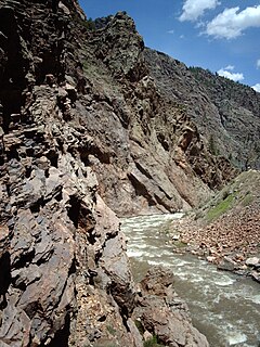
Black Canyon of the Gunnison National Park is an American national park located in western Colorado and managed by the National Park Service. There are two primary entrances to the park: the south rim entrance is located 15 miles (24 km) east of Montrose, while the north rim entrance is 11 miles (18 km) south of Crawford and is closed in the winter. The park contains 12 miles (19 km) of the 48-mile (77 km) long Black Canyon of the Gunnison River. The national park itself contains the deepest and most dramatic section of the canyon, but the canyon continues upstream into Curecanti National Recreation Area and downstream into Gunnison Gorge National Conservation Area. The canyon's name owes itself to the fact that parts of the gorge only receive 33 minutes of sunlight a day, according to Images of America: The Black Canyon of the Gunnison. In the book, author Duane Vandenbusche states, "Several canyons of the American West are longer and some are deeper, but none combines the depth, sheerness, narrowness, darkness, and dread of the Black Canyon."

The Gunnison River is a tributary of the Colorado River, 180 miles (290 km) long,, in the Southwestern state of Colorado. It is the largest tributary of the Colorado River in Colorado, with a mean flow of 2,570 cu ft/s (73 m3/s).

The Salt River is a river in the U.S. state of Arizona. It is the largest tributary of the Gila River. The river is about 200 miles (320 km) long. Its drainage basin is about 13,700 square miles (35,000 km2) large. The longest of the Salt River's many tributaries is the 195-mile (314 km) Verde River. The Salt's headwaters tributaries, the Black River and East Fork, increase the river's total length to about 300 miles (480 km). The name Salt River comes from the fact that the river flows over large salt deposits shortly after the merging of the White and Black Rivers.

Curecanti National Recreation Area is a National Park Service unit located on the Gunnison River in western Colorado. Established in 1965, Curecanti is responsible for developing and managing recreational facilities on three reservoirs, Blue Mesa Reservoir, Morrow Point Reservoir and Crystal Reservoir, constructed on the upper Gunnison River in the 1960s by the U.S. Bureau of Reclamation to better utilize the vital waters of the Colorado River and its major tributaries. A popular destination for boating and fishing, Curecanti offers visitors two marinas, traditional and group campgrounds, hiking trails, boat launches, and boat-in campsites. The state's premiere lake trout and Kokanee salmon fisheries, Curecanti is a popular destination for boating and fishing, and is also a popular area for ice-fishing in the winter months.

Blue Mesa Reservoir is an artificial reservoir located on the upper reaches of the Gunnison River in Gunnison County, Colorado. The largest lake located entirely within the state, Blue Mesa Reservoir was created by the construction of Blue Mesa Dam, a 390-foot tall earthen fill dam constructed on the Gunnison by the U.S. Bureau of Reclamation in 1966 for the generation of hydroelectric power. Managed as part of the Curecanti National Recreation Area, a unit of the National Park Service, Blue Mesa Reservoir is the largest lake trout and Kokanee salmon fishery in Colorado.

Blue Mesa Dam is a 390-foot-tall (120 m) zoned earthfill dam on the Gunnison River in Colorado. It creates Blue Mesa Reservoir, and is within Curecanti National Recreation Area just before the river enters the Black Canyon of the Gunnison. The dam is upstream of the Morrow Point Dam. Blue Mesa Dam and reservoir are part of the Bureau of Reclamation's Wayne N. Aspinall Unit of the Colorado River Storage Project, which retains the waters of the Colorado River and its tributaries for agricultural and municipal use in the American Southwest. The dam's primary purpose is hydroelectric power generation. State Highway 92 passes over the top of the dam. Blue Mesa Dam houses two turbine generators and produces an average of 264,329,000 kilowatt-hours each year.

Morrow Point Dam is a 468-foot-tall (143 m) concrete double-arch dam on the Gunnison River located in Colorado, the first dam of its type built by the U.S. Bureau of Reclamation. Located in the upper Black Canyon of the Gunnison, it creates Morrow Point Reservoir, and is within the National Park Service-operated Curecanti National Recreation Area. The dam is between the Blue Mesa Dam (upstream) and the Crystal Dam (downstream). Morrow Point Dam and reservoir are part of the Bureau of Reclamation's Wayne N. Aspinall Unit of the Colorado River Storage Project, which retains the waters of the Colorado River and its tributaries for agricultural and municipal use in the American Southwest. The dam's primary purpose is hydroelectric power generation.

Middle Bridge is the crossing of Blue Mesa Reservoir on U.S. Route 50 (US 50) within the Curecanti National Recreation Area in southwest Gunnison County, Colorado, United States, about 2.5 miles (4.0 km) east-northeast of the community of Sapinero.

Crystal Dam is a 323-foot-tall (98 m) double curvature, concrete thin arch dam located six miles downstream from Morrow Point Dam on the Gunnison River in Colorado, United States. Crystal Dam is the newest of the three dams in Curecanti National Recreation Area; construction on the dam was finished in 1976. The dam impounds Crystal Reservoir. Crystal Dam and reservoir are part of the Bureau of Reclamation's Wayne N. Aspinall Unit of the Colorado River Storage Project, which retains the waters of the Gunnison River and its tributaries for agricultural and municipal use in the American Southwest. The dam's primary purpose is hydroelectric power generation.

The West Elk Mountains are a high mountain range in the west-central part of the U.S. state of Colorado. They lie primarily within the Gunnison National Forest, and part of the range is protected as the West Elk Wilderness. The range is primarily located in Gunnison County, with small parts in eastern Delta and Montrose counties.
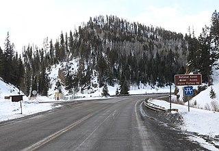
The Cimarron River is a 22.0-mile-long (35.4 km) tributary that joins the Gunnison River in Curecanti National Recreation Area near Cimarron, Colorado. The river's source is the confluence of two forks near Silver Jack Reservoir in the Uncompahgre National Forest.

Sapinero is an unincorporated community located on U.S. Highway 50, along the shore of Blue Mesa Reservoir in the Curecanti National Recreation Area in Gunnison County, Colorado, United States. The U.S. Post Office at Gunnison now serves Sapinero postal addresses. The community was named after Chief Sapinero, a Ute Indian.
U.S. Route 50 (US 50) is a part of the U.S. Highway System that travels from West Sacramento, California, to Ocean City, Maryland. In the U.S. state of Colorado, US 50 is a major highway crossing through the lower midsection of the state. It connects the Western Slope with the lower Front Range and the Arkansas Valley. The highway serves the areas of Pueblo and Grand Junction as well as many other smaller areas along its corridor. The long-term project to upgrade the highway from two lanes to a four lane expressway between Grand Junction and Montrose was completed in January 2005. Only about 25% of the remainder of highway 50 in Colorado is four lane expressway.

The Colorado River Storage Project is a United States Bureau of Reclamation project designed to oversee the development of the upper Colorado River basin. The project provides hydroelectric power, flood control and water storage for participating states along the upper portion of the Colorado River and its major tributaries.

The Curecanti Needle is a 700-ft granite spire located on the Gunnison River in western Colorado. A notable landmark to generations of natives and pioneers, the Needle is located on the southern bank of Morrow Point Reservoir, an impoundment of the Gunnison river between Gunnison and Montrose, Colorado. Used for many years as an advertising symbol for the Denver and Rio Grande Western Railroad, whose narrow-gauge railway famously ran along the northern bank of the river and passed near the Needle, the spire is today part of the Curecanti National Recreation Area, a National Park Service facility that encompasses three impoundments of the Gunnison river, including Morrow Point Reservoir.

Tomichi Creek is a 71.8-mile-long (115.6 km) tributary of the Gunnison River in Gunnison County, Colorado. Tomichi Creek originates north and west of Monarch Pass and flows to the southwest along the base of Monarch Mountain. Congress Creek drains into Tomichi west of Old Monarch Pass where it flows south toward Sargents. Agate Creek flows into Tomichi just north of Sargents where Marshall Creek flows from Marshall Pass. Just below Sargents, Long Branch Creek, flowing out of Baldy Lake from the south, enters Tomichi Creek which takes a westward course where Needle Creek Reservoir drains into Tomichi east of Doyleville. Hot Springs Reservoir drains down Wanita Canyon flowing into Tomichi Creek just west of Doyleville. The Tomichi Valley is a semi-wide valley allowing Tomichi Creek to meander and split into several waterways creating an excellent livestock range and being largely private ranch lands. At Parlin, Quartz Creek flows from Pitkin and Ohio into Tomichi Creek. Tomichi continues its westward journey, slightly northwest, where the Cochetopa Creek drains into Tomichi at State Highway 114 from the south at the intersection of U.S. Highway 50 and continues west to Gunnison where it enters the Gunnison River. A map can be viewed at the BLM Colorado website here.

Morrow Point Reservoir is an 817-acre artificial reservoir on the Gunnison River in western Colorado. Located in the upper Black Canyon of the Gunnison, the lake was created in 1968 by the U.S. Bureau of Reclamation as part of a larger plan to impound the upper section of the Gunnison and create opportunities for hydroelectric power generation, water conservation, and recreation. Morrow Point Reservoir is managed by the National Park Service as a unit within the Curecanti National Recreation Area, and is the location of the Curecanti Needle, a striking 700 ft. granite spire on the reservoir's southern bank whose unique shape was for decades a recognized symbol of the Denver and Rio Grande Western Railroad.
Crystal Reservoir is a 340-acre artificial reservoir on the Gunnison River in western Colorado. Located in the upper Black Canyon of the Gunnison, the lake was created in 1976 by the U.S. Bureau of Reclamation as part of a larger plan to impound the upper section of the Gunnison for the generation of hydroelectric power, water storage, and public recreation. Crystal Reservoir is managed by the National Park Service as an element of the Curecanti National Recreation Area. Located at the far western end of Curecanti, Crystal Reservoir is the smallest, least developed, and least accessible of the three reservoirs within the park.
Blue Creek Canyon is a narrow, steep-walled canyon in Gunnison County, Colorado. It lies between Fitzpatrick Mesa and Blue Mesa and is south of Morrow Point Reservoir and southeast of Cimarron, Colorado. U.S. Highway 50 goes through the canyon. Gunnison County Road 867 intersects with Highway 50 near the middle of the canyon.

