Bluford, Illinois

Last updated

Bluford, Illinois
Jefferson County Illinois Incorporated and Unincorporated areas Bluford Highlighted.svg
Location of Bluford in Jefferson County, Illinois
Illinois in United States (US48).svg
Location of Illinois in the United States
Coordinates: 38°19′33″N88°44′06″W / 38.32583°N 88.73500°W / 38.32583; -88.73500 [1]
CountryUnited States
StateIllinois
County Jefferson
Township Webber
Area
[2]
  Total1.56 sq mi (4.04 km2)
  Land1.56 sq mi (4.04 km2)
  Water0.00 sq mi (0.00 km2)
Elevation
[1]
528 ft (161 m)
Population
 (2020)
  Total630
  Density403.59/sq mi (155.80/km2)
Time zone UTC-6 (CST)
  Summer (DST) UTC-5 (CDT)
Postal code
62814
Area code 618
FIPS code 17-06964
GNIS ID2398145 [1]
Wikimedia CommonsBluford, Illinois

Bluford is a village in Jefferson County, Illinois, in the United States. As of the 2010 census the village population was 688, [3] down from 785 at the 2000 census. It is part of the Mount Vernon Micropolitan Statistical Area.

Contents

Geography

Bluford is in eastern Jefferson County, 1 mile (1.6 km) south of Illinois Route 15 and 9 miles (14 km) east of Mount Vernon, the county seat. According to the 2010 census, Bluford has a total area of 1.458 square miles (3.78 km2), of which 1.45 square miles (3.76 km2) (or 99.45%) is land and 0.008 square miles (0.02 km2) (or 0.55%) is water. [4]

History

The town of Bluford was named after Bluford "Bluf" Green (1868–1912) when he was a small boy [5] by his father Wiley Green (1835–1878), who was the local justice of the peace. An extended story about Bluford by Mrs. Opal H. Wood states:

In 1881, before there was a Bluford, construction was started on the Air Line Railroad, later the Southern Railroad. George Evans, Mt. Vernon banker, laid out the town on 40 acres of land bisected by the railroad. In 1882, Rev. Z. H. Byard, a United Brethren preacher, built the first store building and dwelling. Byard also was the first postmaster in Bluford, and the first railroad station agent. Bluford was incorporated in 1925. Dwight Bressler was its first mayor.

Bluford spread on both sides of the railroad. The south section unofficially was called Tilford, and the north, Bluford, both being names of the sons of Minerva (Flint) and Wiley Green. When son Tilford died, all the town became Bluford. No reason was given why the boys should have been so honored. [6]

Demographics

Historical population
CensusPop.Note
1930 517
1940 463−10.4%
1950 4773.0%
1960 388−18.7%
1970 46519.8%
1980 72856.6%
1990 7472.6%
2000 7855.1%
2010 688−12.4%
2020 630−8.4%
U.S. Decennial Census [7]

As of the census [8] of 2000, there were 785 people, 283 households, and 223 families residing in the village. The population density was 539.1 inhabitants per square mile (208.1/km2). There were 310 housing units at an average density of 212.9 per square mile (82.2/km2). The racial makeup of the village was 98.09% White, 0.13% Native American, 0.13% Asian, 1.02% from other races, and 0.64% from two or more races. Hispanic or Latino of any race were 1.15% of the population.

There were 283 households, out of which 40.3% had children under the age of 18 living with them, 61.5% were married couples living together, 12.0% had a female householder with no husband present, and 21.2% were non-families. 16.6% of all households were made up of individuals, and 8.5% had someone living alone who was 65 years of age or older. The average household size was 2.77 and the average family size was 3.09.

In the village, the population was spread out, with 28.0% under the age of 18, 8.8% from 18 to 24, 28.4% from 25 to 44, 20.9% from 45 to 64, and 13.9% who were 65 years of age or older. The median age was 35 years. For every 100 females, there were 102.3 males. For every 100 females age 18 and over, there were 98.9 males.

The median income for a household in the village was $38,250, and the median income for a family was $40,515. Males had a median income of $29,205 versus $16,641 for females. The per capita income for the village was $15,537. About 8.8% of families and 7.9% of the population were below the poverty line, including 4.7% of those under age 18 and 10.8% of those age 65 or over.

Related Research Articles

<span class="mw-page-title-main">Jefferson County, Illinois</span> County in Illinois, United States

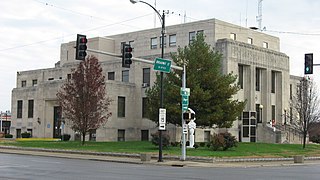
Jefferson County is a county located in the southern part of the U.S. state of Illinois. According to the 2020 census, it has a population of 37,113. The county seat is Mount Vernon.

<span class="mw-page-title-main">Broughton, Illinois</span> Village in Illinois, United States

Broughton is a village in Hamilton County, Illinois, United States. The population was 194 at the 2010 census. It is part of the Mount Vernon Micropolitan Statistical Area.

<span class="mw-page-title-main">Thawville, Illinois</span> Village in Illinois, United States

Thawville is a village in Ridgeland Township, Iroquois County, Illinois, United States. The population was 241 at the 2010 census. The town is 100 miles (160 km) south of Chicago.

<span class="mw-page-title-main">Elkville, Illinois</span> Village in Illinois, United States

Elkville is a village in Jackson County, Illinois, United States. The population was 928 at the 2010 census, down from 1,001 at the 2000 census. As of 2018 the estimated population was 871.

<span class="mw-page-title-main">Belle Rive, Illinois</span> Village in Illinois, United States

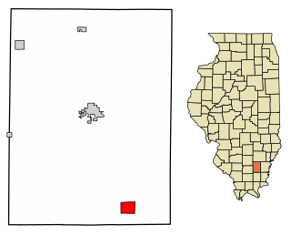
Belle Rive is a village in Jefferson County, Illinois, United States. The population was 361 at the 2010 census. It is part of the Mount Vernon Micropolitan Statistical Area.

<span class="mw-page-title-main">Bonnie, Illinois</span> Village in Illinois, United States

Bonnie is a village located in the southern part of Jefferson County, Illinois. Bonnie had a population of 397 in the 2010 census, down from 424 in the 2000 census. It is part of the Mount Vernon Micropolitan Statistical Area.

<span class="mw-page-title-main">Dix, Illinois</span> Village in Illinois, United States

Dix is a village in Jefferson County, Illinois, United States. The population was 461 at the 2010 census. It is part of the Mount Vernon Micropolitan Statistical Area.

<span class="mw-page-title-main">Ina, Illinois</span> Village in Illinois, United States

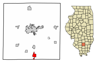
Ina is a village in Jefferson County, Illinois, United States. The population was 2,338 as of the 2010 census. It is part of the Mount Vernon Micropolitan Statistical Area.

<span class="mw-page-title-main">Nason, Illinois</span> City in Illinois, United States

Nason is a city in Jefferson County, Illinois, United States. The population was 236 people as of the 2010 census, making it the least populous incorporated city in the state of Illinois. It is part of the Mount Vernon Micropolitan Statistical Area.

<span class="mw-page-title-main">Waltonville, Illinois</span> Village in Illinois, United States

Waltonville is a village in Jefferson County, Illinois, United States. The population was 434 at the 2010 census. It is part of the Mount Vernon Micropolitan Statistical Area.

<span class="mw-page-title-main">Cypress, Illinois</span> Village in Illinois, United States

Cypress is a village in Johnson County, Illinois, United States. The population was 234 at the 2010 census.

<span class="mw-page-title-main">New Burnside, Illinois</span> Village in Illinois, United States

New Burnside is a village in Johnson County, Illinois, United States. The population was 211 at the 2010 census.

<span class="mw-page-title-main">Lily Lake, Illinois</span> Village in Illinois, United States

Lily Lake is a village in Kane County, Illinois, United States. The town is 15 miles (24 km) southwest of Elgin and 50 miles (80 km) west of Chicago. The village is in the far western part the Chicago metro area. It was incorporated as a village on November 6, 1990. The population was 1,032 at the 2020 census, up from 993 in 2010.

<span class="mw-page-title-main">Bonfield, Illinois</span> Village in Illinois, United States

Bonfield is a village in Kankakee County, Illinois, United States. Bonfield's population was 382 at the 2010 census. It is included in the Kankakee-Bradley, Illinois Metropolitan Statistical Area.

<span class="mw-page-title-main">Buckingham, Illinois</span> Village in Illinois, United States

Buckingham is a village in Kankakee County, Illinois, United States. The population was 300 at the 2010 census, up from 237 at the 2000 census. The village is about 63.7 miles south west of Chicago Illinois. It is included in the Kankakee-Bradley, Illinois Metropolitan Statistical Area.

<span class="mw-page-title-main">Williamsfield, Illinois</span> Village in Illinois, United States

Williamsfield is a village in Knox County, Illinois, United States. The population was 578 at the 2010 census. It is part of the Galesburg Micropolitan Statistical Area.

<span class="mw-page-title-main">Indian Creek, Illinois</span> Village in Illinois, United States

Indian Creek is a village in Vernon Township, Lake County, Illinois, United States. It is part of the Chicago metropolitan area. Per the 2020 census, the population was 536. Police services are provided by Lake County Sheriff and fire/EMS services by the Countryside Fire Protection District.

<span class="mw-page-title-main">Vernon, Illinois</span> Village in Illinois, United States

Vernon is a village in Marion County, Illinois, United States. The population was 103 at the 2020 census.

<span class="mw-page-title-main">Brimfield, Illinois</span> Village in Illinois, United States

Brimfield is a village in Peoria County, Illinois, United States.

<span class="mw-page-title-main">Bush, Illinois</span> Village in Illinois, United States

Bush is a village in Williamson County, Illinois, United States. As of the 2000 census, the village population was 257.

References

  1. 1 2 3 U.S. Geological Survey Geographic Names Information System: Bluford, Illinois
  2. "2020 U.S. Gazetteer Files". United States Census Bureau. Retrieved March 15, 2022.
  3. "Geographic Identifiers: 2010 Census Summary File 1 (G001): Bluford village, Illinois". American Factfinder. U.S. Census Bureau. Archived from the original on February 13, 2020. Retrieved May 14, 2018.
  4. "G001 - Geographic Identifiers - 2010 Census Summary File 1". United States Census Bureau. Archived from the original on February 13, 2020. Retrieved August 2, 2015.
  5. Jefferson County Historical Society 1978, pg 61
  6. Jefferson County Historical Society (1978), Facts and Folks A History of Jefferson County, Illinois, Taylor Publishing Company, Dallas, TX, 61
  7. "Census of Population and Housing". Census.gov. Retrieved June 4, 2015.
  8. "U.S. Census website". United States Census Bureau . Retrieved January 31, 2008.