Blunham railway station

Last updated

Blunham
Blunham railway station 1837008 5d121188.jpg
Blunham Station in 1961
General information
Location Blunham, Central Bedfordshire
England
Grid reference TL149505
Platforms2
Other information
StatusDisused
History
Original companyBedford & Cambridge Railway
Pre-grouping London and North Western Railway
Post-grouping London, Midland and Scottish Railway
London Midland Region of British Railways (1948-1958)
Eastern Region of British Railways (1958-1968)
Key dates
7 April 1862Opened
13 July 1964 [1] Closed to goods
1 January 1968 [2] Closed to passengers

Blunham was a railway station on the Varsity Line which served the small village of the same name in Bedfordshire. Opened in 1862, the station was located in a rural area and saw little passenger traffic; it closed together with the line in 1968.

Contents

History

Travelling from Oxford in the direction of Cambridge, Blunham was the first station on the Varsity Line which was built in the architectural style of the Bedford & Cambridge Railway, a style which included strong gables in yellow gault brick together with red brick dressings and string courses. [3] As with the other Bedford & Cambridge-built stations with the exception of Potton, the main station buildings were situated on the down side and a wooden shelter served for passengers on the up platform. The two platforms were low and steps were often needed to reach coaches, illuminated at night by the station's oil lamps. [4]

The station had a substantial goods shed which contained a 25cwt crane and sidings controlled by a 20-lever frame signal box. [5] A longer private siding led southwards to Beeson's Mill which produced linseed oil on the banks of the River Ivel. [6] The station like many others on the Bedford & Cambridge's line saw much traffic in vegetables - notably potatoes, leading to special trains being laid on to arrange for the collection of goods for carriage to Bletchley and onward transport to London. [7]

The station served a relatively rural community - there were 598 residents in 1901 [8] - and this, coupled with its remote location to the south of Blunham village, left it susceptible to competition from the motor car. [9] The station eventually closed together with the Bedford & Cambridge-built section of the Varsity Line in 1968.

Preceding station Disused railways Following station
Willington   British Railways
Varsity Line
  Girtford Halt

Present day

The main station building has been restored and converted into two semi-detached private residences respectively named "Stationmaster's Cottage" and "Station House". [10] The approach road to the station has been redeveloped as a new housing development called "Old Station Court" which continues westwards across the former railway alignment. To the east, the trackbed is intact including bridge no. 15 over the River Ivel which now forms part of National Cycle Route 51.

Related Research Articles

<span class="mw-page-title-main">Verney Junction railway station</span> Disused railway station in Buckinghamshire, England

Verney Junction railway station was an isolated railway station at a four-way railway junction in Buckinghamshire, open from 1868 to 1968; a junction existed at the site without a station from 1851.

<span class="mw-page-title-main">Fenny Stratford railway station</span> Grade II listed station in Milton Keynes, England

Fenny Stratford is a railway station that serves the Fenny Stratford area of Milton Keynes, Buckinghamshire. It is on the Marston Vale Line that links Bletchley and Bedford, about one mile east of Bletchley railway station.

<span class="mw-page-title-main">Varsity Line</span> Historic Oxford–Cambridge railway

The Varsity Line was the main railway line that linked the English university cities of Oxford and Cambridge, operated by the London and North Western Railway.

<span class="mw-page-title-main">Dunstable Town railway station</span> Former railway station in England

Dunstable Town, also known as Dunstable Church Street, was a railway station on the Great Northern Railway's branch line from Welwyn which served Dunstable in Bedfordshire from 1858 to 1965. Against a background of falling passenger numbers and declining freight returns, the station closed to passengers in 1965 and to goods in 1964, a casualty of the Beeching Axe. The station site is now in use as part of the Luton to Dunstable Busway.

Granborough Road railway station was a station serving the village of Granborough, to the north of Quainton in Buckinghamshire, England.

<span class="mw-page-title-main">Winslow Road railway station</span> Former Metropolitan Railway Station in Buckinghamshire

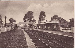
Winslow Road railway station served the village of East Claydon near Winslow to the north of Quainton in Buckinghamshire, England. It was the second station to serve the town after Winslow on the Varsity Line.

<span class="mw-page-title-main">Claydon railway station</span> Disused railway station in Buckinghamshire, England

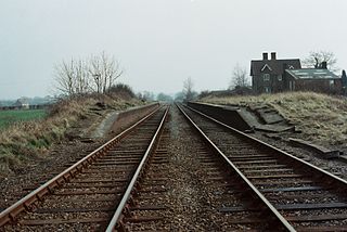
Claydon railway station is a former railway station on the 'Varsity Line', that served the village of Steeple Claydon in Buckinghamshire.

<span class="mw-page-title-main">Lord's Bridge railway station</span> Former railway station in Cambridgeshire, England

Lord's Bridge was a railway station on the Varsity Line which ran between Oxford and Cambridge. Situated in the north of the parish of Harlton on the western outskirts of Cambridge, it was the penultimate station before the line's eastern terminus at Cambridge. The station opened in 1862 and closed more than a century later in 1968. The site is now part of the Mullard Radio Astronomy Observatory, which includes several rail-mounted radio-telescopes.

<span class="mw-page-title-main">Gamlingay railway station</span> Former railway station in Cambridgeshire, England

Gamlingay railway station was a railway station on the Varsity Line which served the small village of Gamlingay in Cambridgeshire, England. The station opened in 1862 and was located in a rural area that saw little passenger traffic; it closed together with the line in 1968.

<span class="mw-page-title-main">Old North Road railway station</span> Former railway station in Cambridgeshire, England

Old North Road was a railway station on the Varsity Line which served the small village of Longstowe near Bourn in Cambridgeshire. As its name suggests, the station was located on the eastern side of the Old North Road, the A1198 road - a major Roman road which linked London with Lincoln. Opened in 1862, the station was located in a rural area and saw little passenger traffic; it closed together with the line in 1968.

<span class="mw-page-title-main">Potton railway station</span> Former railway station in Bedfordshire, England

Potton was a railway station on the Varsity Line which served the small town of the same name in Bedfordshire. Opened in 1857 as part of Sir William Peel's Sandy and Potton Railway, the station was initially situated further south near the Biggleswade Road. Upon being taken over by the Bedford and Cambridge Railway in 1862 a new station was opened which remained in service for over one hundred years before closing in 1968. The station building has survived and is now a private house.

<span class="mw-page-title-main">Winslow railway station</span> Disused railway station in Buckinghamshire, England

Winslow railway station refers to either one of two railway stations which historically served or is planned to serve, the town of Winslow in north Buckinghamshire, England. The original station (1850–1968) was on the former Varsity Line between Cambridge and Oxford. As of September 2022, construction of a new station nears completion and is scheduled to be served by East West Rail, as part of the plan to reinstate the Oxford–Cambridge service.

<span class="mw-page-title-main">Swanbourne railway station</span> Former railway station in Buckinghamshire, England

Swanbourne was a railway station that served the villages of Swanbourne, Little Horwood and Mursley in north Buckinghamshire, England. It was on the mothballed Bicester to Bletchley line, roughly at the centre of a triangle drawn between the three villages. In summer 2020, the station was demolished to clear the route for East West Rail.

Girtford Halt was a short-lived railway halt on the Varsity Line which served the hamlet of Girtford near Sandy in Bedfordshire, England. It was opened by the London, Midland and Scottish Railway in 1938, but closed to passenger traffic two years later in 1940. The line itself closed in 1968, and the site of the railway station has been obliterated by a roundabout.

Willington was a railway station on the Varsity Line which served the small village of the same name in Bedfordshire. Opened in 1903, the station was located in a rural area and saw little passenger traffic; it closed together with the line in 1968.

<span class="mw-page-title-main">Farthinghoe railway station</span> Former railway station in Northamptonshire, England

Farthinghoe was a railway station which served the Northamptonshire village of Farthinghoe in England. It opened in 1851 as part of the Buckinghamshire Railway's branch line to Verney Junction which provided connections to Bletchley and Oxford and closed in 1963.

<span class="mw-page-title-main">Brackley railway station</span> Former railway station in Northamptonshire, England

Brackley Town was a railway station which served the Northamptonshire town of Brackley in England. It opened in 1850 as part of the Buckinghamshire Railway's branch line to Verney Junction which provided connections to Banbury, Bletchley and Oxford and closed in 1963.

<span class="mw-page-title-main">Padbury railway station</span> Former railway station in Buckinghamshire, England

Padbury railway station served the village of Padbury in the English county of Buckinghamshire. It opened in 1878 as part of the Buckinghamshire Railway's branch line to Verney Junction which provided connections to Banbury, Bletchley and Oxford and closed in 1964.

<span class="mw-page-title-main">Wootton Broadmead Halt railway station</span> Former railway station in Bedfordshire, England

Wootton Broadmead Halt was a railway station on the Varsity Line which served the settlement of Wootton Broadmead near Stewartby in Bedfordshire, England. Opened in 1905, it was closed temporarily during both world wars and did not reopen after 1941, officially closing in 1952.

<span class="mw-page-title-main">Olney railway station (England)</span> Former railway station in England

Olney was a railway station on the former Bedford to Northampton Line and Stratford-upon-Avon and Midland Junction Railway which served the town of Olney in Buckinghamshire, England. It was situated on a busy section of line between Towcester and Ravenstone Wood junction which saw heavy use by freight services running between Wales and north-east England. The station closed for passengers in 1962 and completely in 1964, the various connecting routes to the line having closed one by one from the 1950s onwards.

References

  1. Clinker, C.R. (October 1978). Clinker's Register of Closed Passenger Stations and Goods Depots in England, Scotland and Wales 1830-1977. Bristol: Avon-AngliA Publications & Services. p. 14. ISBN   0-905466-19-5.
  2. Butt, R.V.J. (1995). The Directory of Railway Stations, Patrick Stephens Ltd, Sparkford, ISBN   1-85260-508-1, p. 38.
  3. Simpson, Bill (1981). Oxford to Cambridge Railway (Vol. 2). Poole, Dorset: Oxford Publishing Co. p. 94. ISBN   0-86093-121-8.
  4. Davies, R.; Grant, M.D. (1984). Forgotten Railways: Chilterns and Cotswolds. Newton Abbot, Devon: David St John Thomas. p. 120. ISBN   0-946537-07-0.
  5. Mitchell, V.; Smith, K. (February 2007). Bletchley to Cambridge featuring Bedford St. Johns. Midhurst, West Sussex: Middleton Press. p. plates 74 and 76. ISBN   978-1-904474-94-4.
  6. Oppitz, Leslie (2000). Lost Railways of the Chilterns (Lost Railways Series). Newbury, Berkshire: Countryside Books. p. 144. ISBN   978-1-85306-643-6.
  7. Davies, R. and Grant, M.D., p. 119.
  8. Mitchell, V. and Smith, K., plate XIX.
  9. Simpson, Bill (2000). The Oxford to Cambridge Railway: Forty Years On 1960-2000. Witney, Oxford: Lamplight Publications. p.  15. ISBN   1-899246-05-3.
  10. Blunham station. Archived 4 July 2008 at the Wayback Machine

Coordinates: 52°08′29″N0°19′20″W / 52.141348°N 0.322346°W / 52.141348; -0.322346