Related Research Articles

Dunstable Town, also known as Dunstable Church Street, was a railway station on the Great Northern Railway's branch line from Welwyn which served Dunstable in Bedfordshire from 1858 to 1965. Against a background of falling passenger numbers and declining freight returns, the station closed to passengers in 1965 and to goods in 1964, a casualty of the Beeching Axe. The station site is now in use as part of the Luton to Dunstable Busway.
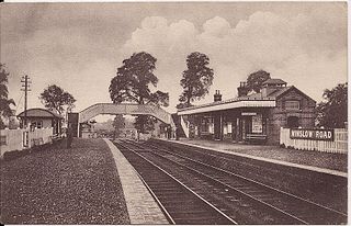
Winslow Road railway station served the village of East Claydon near Winslow to the north of Quainton in Buckinghamshire, England. It was the second station to serve the town after Winslow on the Varsity Line.
Lord's Bridge was a railway station on the Varsity Line which ran between Oxford and Cambridge. Situated in the north of the parish of Harlton on the western outskirts of Cambridge, it was the penultimate station before the line's eastern terminus at Cambridge. The station opened in 1862 and closed more than a century later in 1968. The site is now part of the Mullard Radio Astronomy Observatory, which includes several rail-mounted radio-telescopes.

Gamlingay railway station was a railway station on the Varsity Line which served the small village of Gamlingay in Cambridgeshire, England. The station opened in 1862 and was located in a rural area that saw little passenger traffic; it closed together with the line in 1968.

Old North Road was a railway station on the Varsity Line which served the small village of Longstowe near Bourn in Cambridgeshire. As its name suggests, the station was located on the eastern side of the Old North Road, the A1198 road - a major Roman road which linked London with Lincoln. Opened in 1862, the station was located in a rural area and saw little passenger traffic; it closed together with the line in 1968.

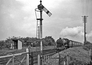
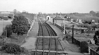
Potton was a railway station on the Varsity Line which served the small town of the same name in Bedfordshire. Opened in 1857 as part of Sir William Peel's Sandy and Potton Railway, the station was initially situated further south near the Biggleswade Road. Upon being taken over by the Bedford and Cambridge Railway in 1862 a new station was opened which remained in service for over one hundred years before closing in 1968. The station building has survived and is now a private house.
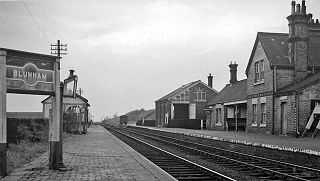
Blunham was a railway station on the Varsity Line which served the small village of the same name in Bedfordshire. Opened in 1862, the station was located in a rural area and saw little passenger traffic; it closed together with the line in 1968.
Willington was a railway station on the Varsity Line which served the small village of the same name in Bedfordshire. Opened in 1903, the station was located in a rural area and saw little passenger traffic; it closed together with the line in 1968.

Five Mile House was a railway station on the Lincolnshire Loop Line which served the village of Fiskerton in Lincolnshire between 1848 and 1964. Situated on the south bank of the River Witham, passengers on the north bank had to use a ferry to reach it. It closed two years after opening due to low traffic, but reopened fifteen years later. Passenger services were withdrawn in 1958, leaving the station open for anglers' excursions until 1964. The Water Rail Way footpath now runs through the site.

Willoughby was a railway station on the East Lincolnshire Railway which served the village of Willoughby in Lincolnshire between 1848 and 1970. In 1886, a second larger station replaced the first following the opening of a junction with the Sutton and Willoughby Railway to Sutton-on-Sea and later Mablethorpe. The withdrawal of goods facilities at Willoughby took place in 1966, followed by passenger services in 1970. All lines through the station are now closed.

Fotherby Halt was a railway halt on the East Lincolnshire Railway which served the village of Fotherby in Lincolnshire between 1905 and 1961. The station was opened on the site of a previous station named Fotherby Gate House which had closed in 1872. The second station closed in 1961, but the line through it remained open for freight until December 1980. The line through the station could be reopened by the Lincolnshire Wolds Railway as part of its extension south from Ludborough to Louth.
Wellingborough London Road railway station is a former railway station in Wellingborough, Northamptonshire on a line which connected Peterborough and Northampton.

Castle Ashby & Earls Barton railway station is a former railway station in Northamptonshire on the former Northampton and Peterborough Railway, a line which connected Peterborough and Northampton.
Balderton railway station was a minor railway station serving the village of Balderton in Cheshire, England. It was located on the Great Western Railway (GWR) main line from London Paddington to Birkenhead Woodside. The 53-yard (48 m) Balderton Tunnel is just south of the station site, and there is an automatic half-barrier (AHB) level crossing adjacent to the site today.
Ramsey East railway station was a railway station in Ramsey, Cambridgeshire, which is now closed. It opened on 16 September 1889, and closed to passenger traffic on 22 September 1930, and to freight traffic on 17 September 1956. The site is now occupied by the west side of Bury Road Industrial Estate, and a new housing development aptly called Signal Road and The Sidings. It was the terminus of a branch line connected via Warboys railway station to Somersham, where it joined the main Great Eastern Railway line between St Ives and March, which at its upper end towards March is now occupied by the route A141 between Chatteris and March.
Brackley Town was a railway station which served the Northamptonshire town of Brackley in England. It opened in 1850 as part of the Buckinghamshire Railway's branch line to Verney Junction which provided connections to Banbury, Bletchley and Oxford and closed in 1963.

Witney railway station served the Oxfordshire town of Witney on the Oxford, Witney and Fairford Railway line. It consisted of two stone-built platforms, a station building, a signal box, and a shed in the form of a pagoda.

Bledlow Bridge Halt railway station was a halt on the Watlington and Princes Risborough Railway which the Great Western Railway opened in 1906 to serve the Buckinghamshire village of Bledlow. The opening of the halt was part of a GWR attempt to encourage more passengers on the line at a time when competition from bus services was drawing away patronage.
Weelsby Road Halt was a railway halt on the East Lincolnshire Railway which served the Weelsby Road area of eastern Grimsby in Lincolnshire between 1905 and 1940. The station was opened as part of a new motor train service between Grimsby and Louth. It was the site of major works in 1933 when a plate girder bridge was constructed to replace a level crossing, enabling road traffic to pass underneath through a subway. The station closed in 1952 following a period of temporary closure during the Second World War. The line through Weelsby remained open for freight until December 1980. The trackbed was later reused by Humberside County Council to construct the A16 Peaks Parkway which now runs through the site. Building of the road put an end to the aspirations of the Great Northern and East Lincolnshire Railway plc to reopen the line as a heritage railway.
Hainton Street Halt was a railway halt on the East Lincolnshire Railway which served the Welholme Road area of Grimsby in Lincolnshire between 1905 and 1961. The station was opened as part of a new motor train service between Grimsby and Louth. The station briefly closed in 1939 as a Second World War economy measure, but reopened in 1940. The line through Hainton Street remained open for freight until December 1980. The trackbed was later reused by Humberside County Council to construct the A16 Peaks Parkway which now runs through the site. Building of the road put an end to the aspirations of the Great Northern and East Lincolnshire Railway plc to reopen the line as a heritage railway.
References
- ↑ Butt, R.V.J. (1995). The Directory of Railway Stations, Patrick Stephens Ltd, Sparkford, ISBN 1-85260-508-1, p. 177.
- ↑ Clinker, C.R. (October 1978). Clinker's Register of Closed Passenger Stations and Goods Depots in England, Scotland and Wales 1830-1977. Bristol: Avon-AngliA Publications & Services. p. 52. ISBN 0-905466-19-5.
- ↑ Simpson, Bill (2000). The Oxford to Cambridge Railway: Forty Years On 1960-2000. Witney, Oxford: Lamplight Publications. p. 120. ISBN 1-899246-05-3.
- ↑ Davies, R.; Grant, M.D. (1984). Forgotten Railways: Chilterns and Cotswolds. Newton Abbot, Devon: David St John Thomas. p. 120. ISBN 0-946537-07-0.
- ↑ Subterranea Britannica, "Girtford Halt".