
Southern Cross is a town in Western Australia, 371 kilometres east of state capital Perth on the Great Eastern Highway. It was founded by gold prospectors in 1888, and gazetted in 1890. It is the major town and administrative centre of the Shire of Yilgarn. At the 2016 census, Southern Cross had a population of 680.

Kalannie is a small town in the Shire of Dalwallinu, in the Wheatbelt region of Western Australia, approximately 259 kilometres (161 mi) north-east of the state capital, Perth.

Tammin is a town in the central agricultural region of Western Australia, 184 kilometres (114 mi) east of Perth and midway between the towns of Cunderdin and Kellerberrin on the Great Eastern Highway.

Kellerberrin is a town in the Wheatbelt region of Western Australia, 205 kilometres (127 mi) east of Perth on the Great Eastern Highway. The town serves as a stop on the Prospector and MerredinLink rural train services. It is also located on the Golden Pipeline Heritage Trail.

Burracoppin is a townsite on the Great Eastern Highway, east of Merredin in the Wheatbelt region of Western Australia.
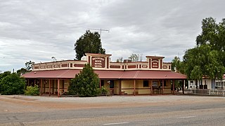
Carrabin is a small town located about 43 kilometres (27 mi) east-north-east of Merredin, on the railway line between Merredin and Southern Cross in Western Australia.
Moorine Rock is located in the eastern agricultural region of Western Australia, 347 km east of Perth and 22 km west south west of Southern Cross.

Doodlakine is a town 220 km (140 mi) east of Perth, Western Australia. It is within the Shire of Kellerberrin along the Great Eastern Highway. The town has a crossing loop for trains on the Perth-to-Kalgoorlie railway and serves as a stop on the MerredinLink rural train service.

Meckering is a town 130 kilometres (80.8 mi) east of Perth, Western Australia along the Great Eastern Highway. Meckering is located within the Shire of Cunderdin.

Hines Hill is a town located 240 km (150 mi) east of Perth, between the towns of Merredin and Doodlakine in Western Australia. The town is situated on the Great Eastern Highway and also on the edge of Lake Baandee. The town has one of the first privately owned weighbridges in Western Australia is located close to the town.

Carnamah is a town in the Mid West region of Western Australia, about 307 kilometres (191 mi) north of Perth along the Midlands Road. According to 2021 census, the population of the town is 407.

Ardath is a small town in the Wheatbelt region of Western Australia 20 kilometres (12 mi) south of the town of Bruce Rock.

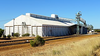
Koorda is a town in the north eastern Wheatbelt region of Western Australia, approximately 236 kilometres (147 mi) east of Perth and 43 kilometres (27 mi) north of Wyalkatchem at the northeastern end of the Cowcowing Lakes. It is the main town in the Shire of Koorda. At the 2016 census Koorda had a population of 414. The surrounding areas produce wheat and other cereal crops. The town is a receival site for Cooperative Bulk Handling.
Kulja is a small town in the Wheatbelt region of Western Australia. The town is situated along the Bonnie Rock to Burakin Road.

Maya is a small town in the Mid West region of Western Australia.
Bowgada is a small town in Western Australia located on the Mullewa Wubin Road 366 kilometres (227 mi) north of Perth in the Mid West region.
Bunjil is a small town in Western Australia located on the Mullewa Wubin Road 326 kilometres (203 mi) north of Perth in the Mid West region. At the 2021 census, it had a population of 61.
Welbungin is a small town located just off the Koorda–Southern Cross road 287 km (178 mi) from Perth in the Wheatbelt region of Western Australia.
Walgoolan is a small town located in the eastern Wheatbelt region of Western Australia. It is situated between Merredin and Bodallin along the Great Eastern Highway.

Pintharuka is an abandoned townsite in the Mid West region of Western Australia. The town is located between the towns of Morawa and Mullewa on the Mullewa-Wubin Road


