Narembeen is a town in the Western Australia wheatbelt. It is 286 km, almost due east, from Perth, the capital of WA. It is the major settlement in the Shire of Narembeen, in which the major industries are growing cereal crops and raising cattle and sheep. The surrounding areas produce wheat and other cereal crops. The town is a receival site for Cooperative Bulk Handling.

Wagin is a town and shire in the Great Southern region of Western Australia, approximately 225 km (139.81 mi) south-east of Perth on the Great Southern Highway between Narrogin and Katanning. It is also on State Route 107. The main industries are wheat and sheep farming.
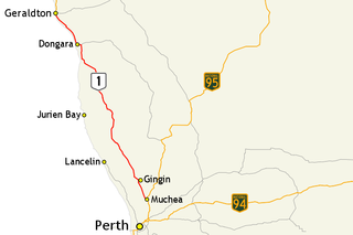
The Brand Highway is a 370-kilometre (230 mi) main highway linking the northern outskirts of Perth to Geraldton in Western Australia. Together with North West Coastal Highway, it forms part of the Western Australian coastal link to the Northern Territory. The highway is a part of Australia's Highway 1, and is for the most part a single carriageway with one lane in each direction.

Dalwallinu is a town in the Wheatbelt region of Western Australia, located 248 km from Perth via the Great Northern Highway. Agriculture and supporting industries are the town's primary economic activities. The town is the first town on the Wildflower Way, a tourist route that stretches north to Mullewa. The town has an elevation of 335 metres (1,099 ft). At the 2016 census, Dalwallinu had a population of 699.

Corrigin is a town in the central Wheatbelt region of Western Australia, 229 kilometres (142 mi) east-southeast of the state capital, Perth, Western Australia, along State Route 40. It is mostly a farming community focused on crops and sheep, and holds the world record of 'the most dogs in a ute'.

Coorow is a town in the Mid West region of Western Australia, 264 kilometres (164 mi) north of Perth.

Moora is a townsite located 177 km north of Perth in the Wheatbelt region of Western Australia. Moora was one of the original stations on the Midland railway line to Walkaway, and the townsite was gazetted in 1895. At the 2016 census, Moora had a population of 1,773.

The Midland Railway of Western Australia (MRWA) was a railway company that built and operated the Midland line in Western Australia. It was listed on the London Stock Exchange. Although having its headquarters in London, it had no association with the English Midland Railway.

The Shire of Moora is a local government area in the northern Wheatbelt region of Western Australia, and generally lies between the Brand Highway and Great Northern Highway about 180 kilometres (112 mi) north of Perth, the state capital. The Shire covers an area of 3,767 square kilometres (1,454 sq mi) and its seat of government is the town of Moora.
Moore River is a river in the Wheatbelt region of Western Australia.

Trayning is a town in the north-eastern Wheatbelt region of Western Australia, 236 kilometres (147 mi) east of the state capital, Perth, on the Nungarin–Wyalkatchem Road. At the 2006 census, Trayning had a population of 122.

Miling is a small town in the Shire of Moora, 200 kilometres (124 mi) north of Perth, Western Australia. At the 2006 census, it had a population of 205.

Quairading is a Western Australian town located in the Wheatbelt region. It is the seat of government for the Shire of Quairading.

Bilbarin is a small town in the Shire of Corrigin in the Wheatbelt region of Western Australia.

Bullaring is a small town located in the Shire of Corrigin in the Wheatbelt region of Western Australia.
Bungulla is a small town located on the Great Eastern Highway in the central Wheatbelt region of Western Australia.
Wannamal is a small town in the Wheatbelt region of Western Australia.

Coomberdale is a small town located along the Midlands Road between Moora and Watheroo in the Wheatbelt region of Western Australia. It had 64 residents in the 2016 census.
Bindi Bindi is a small town located between Moora and Wongan Hills in the Wheatbelt region of Western Australia. It has a population of 72. The town originated as a Western Australian Government Railways siding and was gazetted in 1947. The name is Aboriginal in origin and is the word for stick or skewer on which a coat is hung. The doubling of the word is to indicate many of them.
Koojan is a small town located between Moora and Bindoon in the Wheatbelt region of Western Australia.