
Barwani or Badwani is a municipal town in Barwani district of Madhya Pradesh, India, that is situated near the left bank of the Narmada River. It is the administrative headquarters of Barwani district and has also served as the capital of the former princely state of Barwani. Barwani is only accessible by road.

Narmada district is an administrative district in the state of Gujarat in India. The district headquarters are located at Rajpipla. The district is bounded by Vadodara and Chhota Udaipur districts in the north, by Nandurbar district of Maharashtra state in the east, by Surat and Tapi districts in the south and by Bharuch district in the west. The district occupies an area of 2,755 km2 and has a population of 590,297. It was 10.44% urban as of 2011. As of 2011, it is the third least populous district of Gujarat, after Dang and Porbandar.

Navsari is an administrative district in the state of Gujarat in India, with its headquarters at the city of Navsari. The district covers an area of 2,211 square kilometres and was formed in 1997 after Valsad district was split into Valsad and Navsari districts. It is the largest producer of chikoos in India.

Dabhoi is a town and a municipality in the Vadodara district in the state of Gujarat, India.
Ambaji (Ambājī) is a census town in Banaskantha district in the state of Gujarat, India.
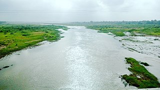
Barwaha is a municipality and sub district in Khargone district in the state of Madhya Pradesh, India situated on the banks of Narmada river. Barwaha is second biggest city of District after Khargone city. The Barwaha city is divided into 28 wards for which elections are held every 5 years. The Barwaha Municipality has population of 61,973 of which 32,940 are males while 29,033 are females as per report released by Census India 2011. Literacy rate of Barwaha is 87.27% higher than state average of 69.32%. In Barwaha, Male literacy is around 92.73% while female literacy rate is 81.23%.
Chhota Udaipur is a district in the Indian state of Gujarat. Established on August 15, 2013, by dividing Vadodara district, it consists of six talukas: Chhota Udepur, Pavijetpur, Kawant, Naswadi, Sankheda, and Bodeli. The district headquarters is located in Chhota Udepur. It is a town and a municipality in Chhota Udaipur district.
Erandol is a town and a taluka in Jalgaon district in the Indian state of Maharashtra state. It is situated on the banks of the Anjani River. The vehicle registration is changed now it's MH-54.

Gangakhed is a city located on banks of Godavari River and a municipal council in Parbhani district in the state of Maharashtra, India. It is also known as Dakshin Kashi. It is also the second largest city In Parbhani District.
Indapur is a town and a municipal council in Pune district in the Indian state of Maharashtra. Indapur is known for Jahagir of Chhatrapati Shivaji Maharaj's father and grandfather. Chhatrapati Shivaji Maharaj's grandfather Malojiraje died in battle in Indapur.
Una is a town and a municipality in Gir Somnath district of the Saurashtra region in the state of Gujarat, India.
Vita, also known as Vite, is a town and a municipal council in Sangli district in the Indian state of Maharashtra. Vita is also taluka headquarters of Khanapur taluka.
Nasvadi is name of a town, a village as well as a Taluka in Chhota Udaipur district of Gujarat, India.
'Sagbara is a Town in Sagbara Taluka in Narmada District of Gujarat State, India. It is located 55 KM towards South from District head quarters Rajpipla. It is a Taluka head quarter.. Its location is at NH-753B Ankleshwar-Valia-Netrang-Dediapada-Sagbara up to State Border to Akkalkuva in Maharashtra
Chhota Udaipur district is a district in the state of Gujarat in India. It was carved out of the Vadodara district on 26 January 2013 with its headquarters at Chhota Udaipur town and is the 28th district of Gujarat.
Barwaha railway station is a main railway station in Khargone district, Madhya Pradesh. Its code is BWW. Barwaha railway station was an important station during meter gauge and all trains took halt here because of Omkareshwar, Maheshwar, CISF, and many industrial factories. The station consists of three platforms. The platforms are not well sheltered. It lacks many facilities including water and sanitation. The station is situated on the 1,000 mmmetre gauge Akola–Ratlam rail line, which is undergoing gauge conversion. Once finished, it will provide vital connectivity between Indore with Southern Indian states.
Chhota Udaipur railway station is a small railway station in Chhota Udaipur district, Gujarat. Its code is CTD and it serves Chhota Udaipur town. The station lacks running water and sanitation and its two platforms are not well sheltered.
The Orsang River flows through the Chhota Udaipur district and Vadodara district in Gujarat, India. It joins with the Narmada River at the village of Chandod. It is originates from the forest of Bhavra in Madhya Pradesh and enters in Gujarat near Chhota Udepur town.
Bodeli railway station is the main railway station in the Indian city of Bodeli in Chhota Udaipur district of Gujarat state.


