
New England is a geographical region in the north of the state of New South Wales, Australia, about 60 km inland from the Tasman Sea. The area includes the Northern Tablelands and the North West Slopes regions. As of 2021, New England had a population of 185,560, with over a quarter of the people living in the area of Tamworth Regional Council.

Gunnedah is a town in north-eastern New South Wales, Australia and is the seat of the Gunnedah Shire local government area. In the 2021 census the town recorded a population of 8,338. Gunnedah is situated within the Liverpool Plains, a fertile agricultural region, with 80% of the surrounding shire area devoted to farming. The Namoi River flows west then north-west through the town providing water beneficial to agricultural operations in the area.

Boggabri is a small town in north-eastern New South Wales, Australia. It is part of Narrabri Shire and lies between Gunnedah and Narrabri on the Kamilaroi Highway. At the 2021 census, the town had a population of 885 people.

The Main North Line is a major railway in New South Wales, Australia. It runs through Strathfield to Wallangarra. The line was the original main line between Sydney and Brisbane, however this required a change of gauge at Wallangarra. As of 1988, the line closed progressively north of Armidale with services gradually withdrawn till 2004, with the main route between Sydney and Brisbane now the North Coast line.

Mungindi is a town and locality on the border of New South Wales (NSW) and Queensland, Australia. The town is within Moree Plains Shire in New South Wales. Within Queensland, the locality is split between the Shire of Balonne and the Goondiwindi Region with the town in the Shire of Balonne. It possesses a New South Wales postcode. Mungindi sits on the Carnarvon Highway and straddles the Barwon River which is the border between New South Wales and Queensland. At the 2016 census, Mungindi had a population of 601 on the New South Wales side, while the population on the Queensland side was 146.
Weemelah is a small village in Moree Plains Shire, New South Wales, Australia. It is 3 km north off the Carnarvon Highway and 27 km east of Mungindi. At the 2006 census, Weemelah had a population of 139.

Cockle Creek railway station is located on the Main Northern line in New South Wales, Australia. It serves the City of Lake Macquarie suburb of Boolaroo. The station is on the eastern side of Cockle Creek and a balloon loop exists west of the creek for the Teralba Colliery.
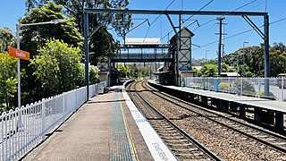
Fassifern railway station is located on the Main Northern line in New South Wales, Australia. It serves the City of Lake Macquarie suburb of Fassifern, opening in 1888.

Baan Baa, pronounced "barn-bar", is a village located in northern inland New South Wales, Australia in Narrabri Shire local government area and Pottinger County. It is approximately 38 kilometres south-east of Narrabri and 58 km north-west of Gunnedah on the Kamilaroi Highway. In the 2006 census, Baan Baa had a population of 211.
The North West Slopes region of New South Wales, Australia, refers generally to the area west of the Northern Tablelands, to the north of the Central West region and to the east of the Far West region. Despite its name, the region is in north-central New South Wales, corresponding generally to the Australian Bureau of Meteorology's forecast area of North West Slopes and Plains. The administrative areas of the region include the city of Tamworth, Gunnedah, Moree, Narrabri and Inverell.
The Sandy Hollow–Gulgong railway line is a railway line in eastern New South Wales, Australia. The line forms a cross country connection from the Main North line in the Upper Hunter region to the Gwabegar line in the Central West region. The line is approximately 125 kilometres (78 mi) in length. From the Gwabegar line, trains can then ultimately reach the Main West line creating a circuitous bypass of Sydney for freight traffic heading between the west and north of New South Wales. The line was opened in 1985.
The Mungindi railway line is a railway line in northern New South Wales, Australia. It branches from the Main North line at Werris Creek station and heads north-west through the towns of Gunnedah and Narrabri before reaching Moree which for many years was the railhead before the extension to Mungindi was constructed. The line is currently truncated to Weemelah between Moree and Mungindi. Passenger trains still operate to Moree, and goods trains operate to Camurra. As of 1 September 2009, services have been suspended between Camurra and Weemelah. The line between Werris Creek and Moree is also known as the North-West line.

Werris Creek railway station is a heritage-listed railway station located at the junction of the Main Northern, Mungindi and Binnaway–Werris Creek lines (Keilbahnhof) in Werris Creek in the Liverpool Plains Shire local government area of New South Wales, Australia. The station serves the town of Werris Creek and was built between 1877 and 1880. The station is also known as Werris Creek Railway Station, yard group and movable relics. The property was added to the New South Wales State Heritage Register on 2 April 1999.
Bellata railway station is located on the Mungindi line in New South Wales, Australia. It serves the village of Bellata, opening on 1 April 1897 as Woolabra when the line was extended from Boggabri to Moree. It was renamed Bellata on 1 March 1909.

Narrabri railway station is located on the Mungindi line in New South Wales, Australia. It serves the town of Narrabri, opening on 1 April 1897 when the line was extended from Boggabri to Moree. Improvements were made to the station in 1920, with the shunting yard increased in size and the platform lengthened by sixty feet.

The Inverell railway line is a closed railway line in New South Wales, Australia. The line branches from the Mungindi line at Moree and travels in an easterly direction through the town of Gravesend then Warialda Rail, gradually increasing in elevation through Delungra towards the terminus at Inverell. An initial estimate of its intended length was 96 miles 35 chains (155.2 km). The line opened in February 1900 as far as Gravesend, then more of the line in 1901 before the Gwydir River bridge was finally finished and the line completed in 1902. It was progressively closed between 1987 and 1994. Currently a 5 km (3.1 mi) section at the Moree end remains in use as a siding for the storage of railway wagons. On 8 August 2016, The NSW Government announced that a 2.8km section of the railway would be reinstated to allow grain to be sent by rail, as part of the Fixing Country Rail pilot round. Up to $2 million was allocated for the project.
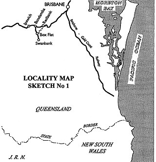
The Redbank-Bundamba Loop Line was a branch line off the Main Line railway near Brisbane, Queensland, Australia. It was built to convey coal from the Bundamba and Redbank areas of the Ipswich coalfields. The Redbank-Bundamba Loop Line ran generally south-west from Redbank station to a point near Bundamba Creek called Box Flat Junction and from that point generally north along Bundamba Creek to Bundamba station.
Gunnedah railway station is located on the Mungindi line in New South Wales, Australia. It serves the town of Gunnedah. It was added to the New South Wales State Heritage Register on 2 April 1999.

Moree railway station is located on the Mungindi line in New South Wales, Australia. It serves the town of Moree.

Willow Tree railway station is located on the Main Northern line in New South Wales, Australia. It serves the village of Willow Tree, opening on 13 August 1877 as Warrah when the line was extended from Murrururundi to Quirindi. It was renamed Willow Tree in 1879.

