
The Helmand River is the longest river in Afghanistan and the primary watershed for the endorheic Sistan Basin. Part of the river is in Iran.
Helmand, also known as Hillmand, in ancient times, as Hermand and Hethumand, is one of the 34 provinces of Afghanistan, in the south of the country. It is the largest province by area, covering 58,584 square kilometres (20,000 sq mi) area. The province contains 13 districts, encompassing over 1,000 villages, and roughly 1,446,230 settled people. Lashkargah serves as the provincial capital.

Lashkargāh, historically called Bost or Boost, is a city in southwestern Afghanistan and the capital of Helmand Province. It is located in Lashkargah District, where the Arghandab River merges into the Helmand River. The city has a population of 201,546 as of 2006. Lashkargah is linked by major roads with Kandahar to the east, Zaranj on the border with Iran to the west, and Farah and Herat to the north-west. It is mostly very arid and desolate. However, farming does exist around the Helmand and Arghandab rivers. Bost Airport is located on the east bank of the Helmand River, five miles north of the junction of the Helmand and Arghandab rivers.

Arghandab is a river in Afghanistan, about 400 km (250 mi) in length. It rises in the Hazarajat country north-west of Ghazni, flows south-west passing near the city of Kandahar, and then falls into the Helmand 30 km (19 mi) below Girishk. In its lower course it is much used for irrigation, under the control of the Helmand and Arghandab Valley Authority, and the valley is cultivated and populous; yet the water is said to be somewhat brackish. It is doubtful whether the ancient Arachotus is to be identified with the Arghandab or with its chief confluent the Tarnak, which joins it on the left 50 km (31 mi) southwest of Kandahar. The Tarnak, which flows south of Kandahar, is much shorter and less copious.
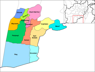
Panjwayi is a district in Kandahar Province, Afghanistan. It is located about 35 kilometres (22 mi) west of Kandahar. The district borders Helmand Province to the southwest, Maywand District to the west, Zhari District to the north, Arghandab, Kandahar and Daman districts to the east and Reg District to the south. Panjwayi was reduced in size in 2004 when Zhari District was created out of the northern part of it, on the northern side of the Arghandab River, which now forms the northern boundary.
Daman District is situated in the central part of the Kandahar Province, Afghanistan. It borders Panjwai and Kandahar districts to the west, Shah Wali Kot District to the north, Zabul Province to the northeast, Arghistan and Spin Boldak districts to the east and Reg District to the south. The population is 30,700 (2006). The center is the village of Daman, located in the central part of the district. The area is irrigated by the Helmand and Arghandab Valley Authority.
Arghandab is a district in the central part of Kandahar Province, Afghanistan. It borders Panjwai and Khakrez districts to the west, Shah Wali Kot District to the north and east and Kandahar District to the east and south.

Grishk, also spelled Girishk or Gereshk, is a town in Grishk District in Helmand province on the Helmand River in Afghanistan, some 120 km (75 mi) northwest of Kandahar, at 817 metres (2,680 ft) altitude. Upstream lies the Kajaki Dam which diverts water to the Boghra Irrigation Canal, an essential infrastructure for the region's crops. Grishk Dam is also nearby. Grishk was originally built around a fort on the east bank of the river but was later rebuilt on the west. The fort was twice captured by the British: first in the First Anglo-Afghan War and again in 1879. In both cases the fort was later abandoned. Grishk has a population of about 48,546 and has a hospital and a school of engineering which was built back in 1957.
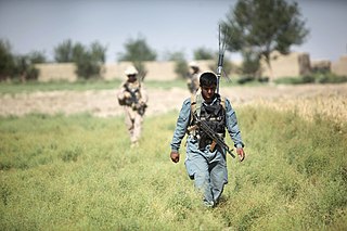
Operation Mountain Thrust was a NATO and Afghan-led operation in the War in Afghanistan, with more than 3,300 British troops, 2,300 U.S., 2,200 Canadian troops, about 3,500 Afghan soldiers and large air support. Its primary objective was to quell the ongoing Taliban insurgency in the south of the country.

Nad Ali or Nad-e Ali is a district in Helmand Province, Afghanistan. Marja is an unincorporated agricultural district in Nad Ali. The area is irrigated by the Helmand and Arghandab Valley Authority (HAVA). A small town of the same name lies 11 km to the west of the Helmand River, at the coordinates shown at the top of the page. The town of Nad-e Ali was built in 1954 as part of the HAVA irrigation project, and was settled by 3,000 predominantly Pashtun families who were given newly arable land.

Sangin is a district in the east of Helmand Province, Afghanistan. Its population was reported at 58,100 in 2012, all of which belong to Pashtun ethnic group. The district centre is the town of Sangin. The area is irrigated by the Helmand and Arghandab Valley Authority.

The Afghan Minister of Agriculture, Irrigation & Livestock is the Government of Afghanistan Cabinet officer responsible for managing Afghanistan's agriculture policy.
Garmsir District is located in the southern part of Helmand Province, Afghanistan. The district is large, but all the villages are along the Helmand River. The rest is a desert. The district capital, Garmsir, is located in the northwestern part of the district on the east bank of Helmand River.

Reg (Khanashin) District is situated in the southeastern part of Helmand Province, Afghanistan along the Helmand River on its western bank. The population is 25,600. The main village is Khanashin.
The following lists events that happened during 1953 in Afghanistan.

The Registan Desert, also known as Rigestan Desert, is an extremely arid plateau region located between Helmand and Kandahar provinces in southeastern Afghanistan. It is a sandy desert consisting of small, red sand hills about 50–100 feet (15–30 m) high, sand-covered plains, and open rocky and clay-covered areas. The underlying base of the hills consists of partly stabilized ancient transverse dunes, reflecting a west-to-east wind and nearly unlimited sand supply. The desert is very sparsely populated by Baluchi and Pashtun nomads. The desert is gradually encroaching on surrounding agricultural areas.

The Dahla Dam, also known as Arghandab Dam and Kasa, is located in the Shah Wali Kot District of Kandahar Province in Afghanistan, approximately 40 kilometres (25 mi) north of the provincial capital Kandahar. Constructed in 1952, it is said to be the second largest dam in Afghanistan. As of 2019, the Afghan government is spending $450 million dollars on making the dam more useful. The project includes raising the dam's walls by 12 meters so its reservoir can hold nearly a billion cubic meters of fresh water and installing three turbines for the production of 22 megawatts (MW) of electricity.

Marjah is an agricultural town in southern Afghanistan. It has been reported to have a population between 80,000 and 125,000, but some sources argue that its population is much smaller and is spread across 80 to 125 km2, an area larger than Cleveland or Washington, D.C. Another source described Marjah as "a cluster of villages" and "a community of 60,000 persons". The town sits in Nad Ali District of Helmand Province, southwest of the provincial capital Lashkar Gah.
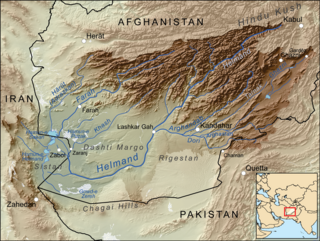
The Helmand and Arghandab Valley Authority (HAVA) based in Lashkar Gah, Afghanistan, originally named the Helmand Valley Authority (HVA) until its expansion in 1965, was established on December 4, 1952, as an agency of the Afghan Government. The agency was modelled on the Tennessee Valley Authority in the United States, with a remit covering lands in Farah Province, Ghazni Province, Helmand Province, Herat Province, and Kandahar Province.

Qala-e-Bost, also romanized Qalai Bust, is a fortress in Bost, Afghanistan, built 3000 years ago. It is located at 31° 30’ 02″ N, 64° 21’ 24″ E near the convergence of the Helmand and Arghandab Rivers, a half-hour's drive south of Lashkargah. Qala-e-Bost is famous for its 11th century decorative arch, which appears on the 100 Afghani note. The arch is part of the remains of a mosque.
