Helmand and Arghandab Valley Authority

Last updated
Map of the Helmand River drainage basin including the Arghandab River tributary Helmandrivermap.png
Map of the Helmand River drainage basin including the Arghandab River tributary
The Kajakai Dam on the Helmand River, one of the major dams controlled by the HAVA AfghanistanHelmandKajakaiDamm.jpg
The Kajakai Dam on the Helmand River, one of the major dams controlled by the HAVA

The Helmand and Arghandab Valley Authority (HAVA) based in Lashkar Gah, Afghanistan, originally named the Helmand Valley Authority (HVA) until its expansion in 1965, [1] was established on December 4, 1952, as an agency of the Afghan Government. [2] The agency was modeled on the Tennessee Valley Authority in the United States, [3] [4] [5] with a remit covering lands in Farah Province, Ghazni Province, Helmand Province, Herat Province, and Kandahar Province. [2]

Contents

The HAVA is overseen by the Afghan Ministry of Agriculture, Irrigation and Livestock (previously the Ministry of Agriculture and Irrigation). [6]

History

The HAVA was created to manage the economic development of the Helmand and Arghandab valleys, primarily through irrigation and agricultural land development along the Helmand River and the Arghandab River, in a plan which was forecast to be of primary importance to the future economy of Afghanistan. [2] Before the outbreak of conflict in the late 1970s, the area irrigated by the HAVA produced a large proportion of Afghanistan's grain and cotton [7] and was a major source of foreign exchange through exports. [8] The area of agricultural land under irrigation more than halved between 1979 and 2002 to around 1,500,000 hectares (5,800  sq mi ), although this has since been increased. [9]

The project received major loans from the Export–Import Bank of the United States and, although around 20% of all Afghan Government expenditure went into funding the HVA and HAVA during the 1950s and into the 1960s, [2] [3] it was generally seen as a US-led project. [2] It resulted, in the words of historian Arnold J. Toynbee in "a piece of America inserted into the Afghan Landscape. ... The new world they are conjuring up out of the desert at the Helmand River's expense is to be an America-in-Asia." [3]

2000s

In 2005, it was reported that, following a United States Agency for International Development funded project to build six reservoirs in Lashkar Gah, the HAVA would manage the provision of fresh water connections to the city's residents and the collection of the associated fees to keep the system maintained. The city had been without fresh water for the previous 30 years due to the contamination of the Helmand River. [10]

During the Helmand province campaign, the Operation Tethys initiative by the British Royal Engineers 170 (Infrastructure Support) Group led to repairs being carried out to the HAVA's irrigation systems between 2010 and 2012 [11] at 30 sites. [12]

During 2011, it was reported that work was being started on a Helmand River Basin Study and Master Plan (HRBMP) to rebuild the capacity of the HAVA [13] with funding from the British Department for International Development. [14]

Present day

Today, the irrigation system managed by the HAVA is regarded as one of the country's most important capital resources [15] and vital for maintaining and expanding agricultural production in the region. [16]

As of March 2012, its director is Haji Khan Agha. [17]

Development

The development of the Helmand Valley was initiated by the Government of Afghanistan in 1946. [2] In addition to irrigation and land development it also included elements of flood control and power supply, improvements to farming practices and equipment, health, education and road connections and the resettlement of some 5,500 nomadic and landless families into the area. [1] [2] It focused around irrigation supplied from the waters of the Arghandab (Dahla) Dam, completed in 1952, and the Kajaki Dam on the River Helmand, completed in 1953, which were both constructed by a local subsidiary of Morrison Knudsen, the builders of the Hoover Dam. [2] It resulted in one of the world's major desert irrigation schemes, with water supplied through the Boghra, Shamalan, and Darweshan canals. [18]

Government involvement

The US Government was officially involved in the project from 1949 until the Soviet invasion in 1979. [1] Between 1949 and 1971, the US financed eight dams on the Helmand River. [19] From 1960, the Agency for International Development and its predecessor, the Technical Cooperation Agency, spent $80 million assisting with 25 projects and the HAVA became a showcase for the US foreign aid program. [1] [8]

The earliest initiatives to build a modern irrigation system in the region began in 1935, with financial support from the Japanese Government though until World War II. [1] [20] The German Government had also provided assistance. [1]

Areas irrigated by the HAVA

In Helmand Province, the areas of Nad Ali, Marja, Shamalon, Darweshan, Khanishin, Seraj, Girishk, Sanguin-Kajakai, Musa Qala and Nowzad are all irrigated by the HAVA, as are the areas of Maiwand, Dund-Daman, Arghandab and Panjwayi in Kandahar Province. [1]

Issues

While the development of the Helmand valley resulted in considerable gains in agricultural production and raised average farm incomes tenfold, there have also been problems. [1] In particular, by 1975, over-irrigation and poor drainage had led to waterlogging and salination, seriously damaging the soil in some places. [1] Work to mitigate this was interrupted by the Soviet invasion. [1] Following the overthrow of the Najibullah Government in 1992 and aided by the irrigation, the Helmand valley region has become a major area for the cultivation of the opium poppy, a crop which had been largely suppressed by the HAVA in the 1950s. [21]

Irrigation of the area has also significantly reduced the water flowing from the Helmand River into Lake Hamun and this, together with drought, has been cited as a key reason for the severe damage to the ecology of the lake region, much of which has degenerated since 1999 from a wetland of international importance into salt flats. [9] [22]

See also

Related Research Articles

<span class="mw-page-title-main">Helmand River</span> Major river in Afghanistan

The Helmand River is the longest river in Afghanistan and the primary watershed for the endorheic Sistan Basin. It emerges in the Sanglakh Range of the Hindu Kush mountains in the northeastern part of Maidan Wardak Province, where it is separated from the watershed of the Kabul River by the Unai Pass. The Helmand feeds into the Hamun Lake on the border between Afghanistan and Iran.

<span class="mw-page-title-main">Helmand Province</span> Largest Province of Afghanistan

Helmand, also known as Hillmand, in ancient times, as Hermand and Hethumand, is one of the 34 provinces of Afghanistan, in the south of the country. It is the largest province by area, covering 58,584 square kilometres (20,000 sq mi) area. The province contains 18 districts, encompassing over 1,000 villages, and roughly 1,446,230 settled people. Lashkargah serves as the provincial capital. Helmand was part of the Greater Kandahar region until made into a separate province by the Afghan government in the 20th century.

Hava or HAVA may refer to:

<span class="mw-page-title-main">Lashkargah</span> City in Helmand Province, Afghanistan

Lashkargāh, historically called Bost or Boost, is a city in southwestern Afghanistan and the capital of Helmand Province. It is located in Lashkargah District, where the Arghandab River merges into the Helmand River. The city has a population of 201,546 as of 2006. Lashkargah is linked by major roads with Kandahar to the east, Zaranj on the border with Iran to the west, and Farah and Herat to the north-west. It is mostly very arid and desolate. However, farming does exist around the Helmand and Arghandab rivers. Bost Airport is located on the east bank of the Helmand River, five miles north of the junction of the Helmand and Arghandab rivers. Because of the trading hubs, it is Afghanistan's second largest city in size, after Kabul and before Kandahar.

<span class="mw-page-title-main">Arghandab River</span> River in Afghanistan

The Arghandab is a river in Afghanistan, about 400 km (250 mi) in length. It rises in Ghazni Province, west of the city of Ghazni, and flows southwest, passing near the city of Kandahar, before joining the Helmand River 30 km (19 mi) below the town of Grishk. In its lower course, it is much used for irrigation, under the control of the Helmand and Arghandab Valley Authority, and the valley is cultivated and populous; yet the water is said to be somewhat brackish. It is doubtful whether the ancient Arachotus is to be identified with the Arghandab or with its chief confluent the Tarnak, which joins it on the left 50 km (31 mi) southwest of Kandahar. The Tarnak, which flows south of Kandahar, is much shorter and less copious.

<span class="mw-page-title-main">Panjwayi District</span> District of Kandahar Province, southeastern Afghanistan

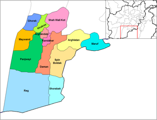
Panjwayi is a district in Kandahar Province, Afghanistan. It is located about 35 kilometres (22 mi) west of Kandahar. The district borders Helmand Province to the southwest, Maywand District to the west, Zhari District to the north, Arghandab, Kandahar and Daman districts to the east and Reg District to the south. Panjwayi was reduced in size in 2004 when Zhari District was created out of the northern part of it, on the northern side of the Arghandab River, which now forms the northern boundary.

<span class="mw-page-title-main">Arghandab District, Kandahar</span> Settlement in Afghanistan

Arghandab is a district in the central part of Kandahar Province, Afghanistan. It borders Panjwai and Khakrez districts to the west, Shah Wali Kot District to the north and east and Kandahar District to the east and south.

<span class="mw-page-title-main">Grishk</span> Town in Helmand Province, Afghanistan

Grishk, also spelled Gereshk, is the new name of Zamindawar which is named after the invasion the region by Nader Afshar army and given to Ghilji tribe in 18th century. Grishk a town in Grishk District of Helmand province, geographically located along the Helmand River in Afghanistan, some 120 km (75 mi) northwest of Kandahar, at 817 metres (2,680 ft) altitude. Upstream lies the Kajaki Dam which diverts water to the Boghra Irrigation Canal, an essential infrastructure for the region's crops. Grishk Dam is also nearby. Grishk was originally built around a fort on the east bank of the river but was later rebuilt on the west. The fort was twice captured by the British: first in the First Anglo-Afghan War and again in 1879. In both cases the fort was later abandoned. Grishk has a population of about 48,546 and has a hospital and a school of engineering which was built back in 1957.

<span class="mw-page-title-main">Opium production in Afghanistan</span> Overview of illicit drug production in Afghanistan

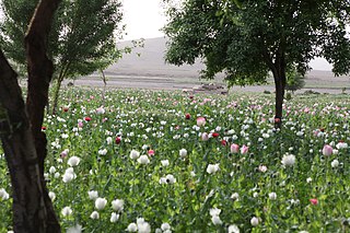
Afghanistan has long had a history of opium poppy cultivation and harvest. As of 2021, Afghanistan's harvest produces more than 90% of illicit heroin globally, and more than 95% of the European supply. More land is used for opium in Afghanistan than is used for coca cultivation in Latin America. The country has been the world's leading illicit drug producer since 2001. In 2007, 93% of the non-pharmaceutical-grade opiates on the world market originated in Afghanistan. By 2019 Afghanistan still produced about 84% of the world market. This amounts to an export value of about US $4 billion, with a quarter being earned by opium farmers and the rest going to district officials, insurgents, warlords, and drug traffickers. In the seven years (1994–2000) prior to a Taliban opium ban, the Afghan farmers' share of gross income from opium was divided among 200,000 families.

Sher Mohammed Akhundzada is an Alizai tribal leader who was the Governor of Helmand in Afghanistan from 2001 to 2005. As governor, he implemented various agricultural projects in Helmand, including canal excavation from the Kajaki dam for irrigation and electricity generation projects. He was deeply involved in opium production and smuggling, leading to his removal from office by the Afghan government in 2005 after lobbying by the British, who were leading counter-narcotic efforts in Afghanistan at the time. He was succeeded as governor of Helmand by Mohammad Daoud.

<span class="mw-page-title-main">Kajaki Dam</span> Dam in Helmand, Afghanistan

The Kajaki Dam is "an earth and rockfill embankment type dam" located on the Helmand River in the Kajaki District of Helmand Province in Afghanistan, about 161 km (100 mi) northwest of Kandahar. It has a hydroelectric power station, which is operated by the Helmand and Arghandab Valley Authority through the Ministry of Energy and Water.

<span class="mw-page-title-main">Nad Ali District</span> District in Helmand Province, Afghanistan

Nad Ali or Nad-e Ali is a district in Helmand Province, Afghanistan. Marja is an unincorporated agricultural district in Nad Ali. The area is irrigated by the Helmand and Arghandab Valley Authority (HAVA). A small town of the same name lies 11 km to the west of the Helmand River, at the coordinates shown at the top of the page. The town of Nad-e Ali was built in 1954 as part of the HAVA irrigation project, and was settled by 3,000 predominantly Pashtun families who were given newly arable land.

<span class="mw-page-title-main">Sangin District</span> District in Helmand Province, Afghanistan

Sangin is a district in the east of Helmand Province, Afghanistan. Its population was reported at 58,100 in 2012, all of which belong to Pashtun ethnic group. The district centre is the town of Sangin. The area is irrigated by the Helmand and Arghandab Valley Authority.

<span class="mw-page-title-main">Nawzad, Afghanistan</span> Small town in Nangarhar Province

Nawzad is a small town, the centre of Nawzad District in Helmand Province, Afghanistan. It is located at 32.4000°N 64.4667°E at an altitude of 1221 metres ASL. It was the site of the Battle of Nawzad.

<span class="mw-page-title-main">Nawa-I-Barakzayi District</span> District in Helmand Province, Afghanistan

Nāwa-I-Barakzāyi District is an administrative district in Helmand Province, Afghanistan located south of the provincial capital of Lashkar Gah along the Helmand River. It is bordered by the districts of Lashkar Gah, Nad Ali, Garmsir, and Rig, as well as the provinces of Nimruz and Kandahar. It falls within the area known as Pashtunistan,, an area comprising most of southeast Afghanistan and northwest Pakistan. The dominant language is Pashto and many of the 89,000 residents practice the traditional code of Pashtunwali. Nawa-I-Barakzayi's name reflects the dominant Pashtun tribe in the district, the Barakzai. Prior to the 1970s, it was called Shamalan after a small village at the south end of the district

<span class="mw-page-title-main">Khanashin District</span> District in Helmand Province, Afghanistan

Reg (Khanashin) District is situated in the southeastern part of Helmand Province, Afghanistan along the Helmand River on its western bank. The population is 25,600. The main village is Khanashin.

The following lists events that happened during 1953 in Afghanistan.

<span class="mw-page-title-main">Dahla Dam</span> Dam in Kandahar Province, Afghanistan

The Dahla Dam, also known as Arghandab Dam and Kasa, is located in the Shah Wali Kot District of Kandahar Province in Afghanistan, approximately 40 kilometres (25 mi) north of the provincial capital Kandahar. Constructed in 1952, it is said to be the second largest dam in Afghanistan. In 2019, the Afghan government was spending $450 million upgrading the dam. The project included raising the dam's walls by 12 meters so the reservoir could hold nearly a billion cubic meters of fresh water and installing three turbines to produce 22 megawatts (MW) of electricity.

<span class="mw-page-title-main">Marjah</span> Town in Helmand Province, Afghanistan

Marjah is an agricultural town in southern Afghanistan. It has been reported to have a population between 80,000 and 125,000, but some sources argue that its population is much smaller and is spread across 80 to 125 km2, an area larger than Cleveland or Washington, D.C. Another source described Marjah as "a cluster of villages" and "a community of 60,000 persons". The town sits in Nad Ali District of Helmand Province, southwest of the provincial capital Lashkar Gah.

<span class="mw-page-title-main">Barry N. Haack</span> American geographer

Barry N. Haack is an American geographer and Emeritus Professor in the Department of Geography and Geoinformation Science at George Mason University in Fairfax, Virginia. He is an international authority on remote sensing, geographic information systems (GIS), and technology transfer from developed to developing nations. Haack is a visiting physical scientist at the United States Geological Survey and an elected Fellow in the American Society for Photogrammetry and Remote Sensing (ASPRS). Through education and collaboration, Haack has influenced the careers of scientists and decision makers from many United States federal agencies and in universities and agencies in nearly thirty countries. He has held formal arrangements with the United Nations, World Bank, Inter-American Development Bank, NASA, the European Space Agency, the National Geographic Society, and many other international organizations and country governmental agencies.

References

  1. 1 2 3 4 5 6 7 8 9 10 (pdf) The Helmand Valley Project in Afghanistan: A.I.D. Evaluation Special Study No. 18 C Clapp-Wicek & E Baldwin, United States Agency for International Development, published December 1983
  2. 1 2 3 4 5 6 7 8 Report on Development of Helmand Valley, Afghanistan, 1956, Tudor Engineering Company
  3. 1 2 3 Cullather, Nick (September 2002). "Damming Afghanistan: Modernization in a Buffer State". Journal of American History . 89 (2): 512–537. doi:10.2307/3092171. JSTOR   3092171.
  4. Curtis, Adam (13 October 2009). "Kabul: City Number One - Part 3". BBC . Retrieved 2023-03-21.
  5. Reconstruction And Opium Poppy Cultivation in Central Helmand: The Need For An Integrated Program Richard B. Scott, Conference on Afghanistan Reconstruction, University of Nebraska at Omaha, published 2008-10-03
  6. Report and Recommendation of the President to the Board of Directors on the Proposed Loan and Technical Assistance to the Republic of Afghanistan for the Kajakai Gales Project in Afghanistan [ permanent dead link ] Asian Development Bank, published 1974-11-12
  7. Haack, Barry (1997). "Afghanistan irrigation system assessment using remote sensing". AIP Conf. Proc. 387: 195–202. doi:10.1063/1.52116. Archived from the original on 2012-07-15. Retrieved 2012-05-04.
  8. 1 2 "Geology, Water, and Wind in the Lower Helmand Basin, Southern Afghanistan" (PDF). United States Agency for International Development . United States Geological Survey. Archived from the original (PDF) on 2011-10-28.
  9. 1 2 Making the Most of Afghanistan’s River Basins: Opportunities for Regional Cooperation, Matthew King & Benjamin Sturtewagen, EastWest Institute, published 2010, accessed 2012-05-11
  10. "USAID Field Report Afghanistan Feb 2005". ReliefWeb . United States Agency for International Development. 28 Feb 2005. Retrieved 2023-03-21.
  11. Geological Society - Operation Tethys Geoscientist 21.06 July 2011
  12. "Troops help to eliminate Afghan poppies". Yorkshire Post . 18 March 2012. Archived from the original on 2016-03-07.
  13. House of Commons - Defence Committee - Written Evidence prepared 2011-07-17
  14. Stabilisation Case Study: Infrastructure in Helmand, Afghanistan (Experiences from Helmand 2008-2010) Archived 2012-10-30 at the Wayback Machine Department for International Development
  15. Haack, Barry; Wolf, James; English, Richard (1998). "Remote sensing change detection of irrigated agriculture in Afghanistan". Geocarto International . 13 (2): 65–75. doi:10.1080/10106049809354643.
  16. Helmand Annual Review 2010 Archived 2015-05-24 at the Wayback Machine Helmand Provincial Reconstruction Team, Regional Command (South West) and the Regional Platform (South West), published 2011-03-12
  17. Shively, L.A. (2012-03-01). "Summit on water conservation brings Afghan provincial leadership to the table". Defense Visual Information Distribution Service . Retrieved 2023-03-21.
  18. Owens, G.P. (December 15, 1971). "1970 Farm Economic Survey: Helmand and Arghandab Valleys of Afghanistan" (PDF). United States Agency for International Development . University of Wyoming. Archived from the original (PDF) on 2015-07-01.
  19. Introduction to Geographical Hydrology: Spatial Aspects of the Interactions Between Water Occurrence and Human Activity, Richard Chorley (editor), Taylor & Francis, ISBN   9780416688306, published 1971
  20. Helmand-Arghandab Valley Irrigation System - A Change Assessment: 1973 - 1990 Development Alternatives Inc & Earth Satellite Corporation, published February 1993
  21. "Afghanistan's drug industry: Structure, functioning, dynamics and implications for counter-narcotics policy". ReliefWeb . United Nations Office on Drugs and Crime. 2006-11-28. Retrieved 2023-03-21.
  22. Weier, John (13 December 2002), From Wetland to Wasteland; Destruction of the Hamoun Oasis, NASA Earth Observatory , retrieved 11 May 2012

Further reading