Dry lake

Last updated
Namak Lake, Qom Province, Iran Hows-e Sultan.jpg
Namak Lake, Qom Province, Iran

A dry lake bed, also known as a playa, is a basin or depression that formerly contained a standing surface water body, which disappears when evaporation processes exceed recharge. If the floor of a dry lake is covered by deposits of alkaline compounds, it is known as an alkali flat. If covered with salt, it is known as a salt flat.

Contents

Terminology

If its basin is primarily salt, then a dry lake bed is called a salt pan , pan, or salt flat (the latter being a remnant of a salt lake). Hardpan is the dry terminus of an internally drained basin in a dry climate, a designation typically used in the Great Basin of the western United States.[ citation needed ]

The Chott el Djerid in Tunisia Tunisia 10-12 - 141 - Salt Flats (6609472321).jpg
The Chott el Djerid in Tunisia

Another term for dry lake bed is playa. The Spanish word playa (pronounced  [ˈplaʝa] ) literally means "beach". Dry lakes are known by this name in some parts of Mexico and the western United States. This term is used e.g. on the Llano Estacado and other parts of the Southern High Plains and is commonly used to address paleolake sediments in the Sahara like Lake Ptolemy.

In South America, the usual term for a dry lake bed is salar or salina, Spanish for salt pan.

Pan is the term used in most of South Africa. These may include the small round highveld pans, typical of the Chrissiesmeer area, to the extensive pans of the Northern Cape province.

Terms used in Australia include salt pans (where evaporite minerals are present) and clay pans. [1]

In Arabic, a salt flat is called a sabkha (also spelled sabkhah, subkha or sebkha) or shott ( chott ). In Central Asia, a similar "cracked mud" salt flat is known as a takyr. In Iran salt flats are called kavir.

Formation

Salt harvesting in Salar de Uyuni, Bolivia, the world's largest salt flat Piles of Salt Salar de Uyuni Bolivia Luca Galuzzi 2006 a.jpg
Salt harvesting in Salar de Uyuni, Bolivia, the world's largest salt flat
Sailing stone in Racetrack Playa Racetrack Playa in Death Valley National Park.jpg
Sailing stone in Racetrack Playa

A dry lake is formed when water from rain or other sources, like intersection with a water table, flows into a dry depression in the landscape, creating a pond or lake. If the total annual evaporation rate exceeds the total annual inflow, the depression will eventually become dry again, forming a dry lake. Salts originally dissolved in the water precipitate out and are left behind, gradually building up over time. A dry lake appears as a flat bed of clay, generally encrusted with precipitated salts. These evaporite minerals are a concentration of weathering products such as sodium carbonate, borax, and other salts. In deserts, a dry lake may be found in an area ringed by bajadas.

Dry lakes are typically formed in semi-arid to arid regions of the world. The largest concentration of dry lakes (nearly 22,000) is in the southern High Plains of Texas and eastern New Mexico.[ citation needed ] Most dry lakes are small. However, Salar de Uyuni in Bolivia, near Potosí, the largest salt flat in the world, comprises 4,085 square miles (10,582 square km). [2]

Many dry lakes contain shallow water during the rainy season, especially during wet years. If the layer of water is thin and is moved around the dry lake bed by wind, an exceedingly hard and smooth surface may develop. Thicker layers of water may result in a "cracked-mud" surface and teepee structure desiccation features. If there is very little water, dunes can form.

The Racetrack Playa, located in Death Valley, California, features a geological phenomenon known as "sailing stones" that leave linear "racetrack" imprints as they slowly move across the surface without human or animal intervention. These rocks have been recently filmed in motion by the Scripps Institution of Oceanography at UC San Diego and are due to a perfect coincidence of events. First, the playa has to fill with water, which must be deep enough to form floating ice during winter, but still shallow enough that the rocks are exposed. When the temperature drops at night, this pond freezes into thin sheets of "windowpane" ice, which then must be thick enough to maintain strength, but thin enough to move freely. Finally, when the sun comes out, the ice melts and cracks into floating panels; these are blown across the playa by light winds, propelling the rocks in front of them. [3] The stones only move once every two or three years and most tracks last for three or four years. [4]

Ecology

While a dry lake bed is itself typically devoid of vegetation, they are commonly ringed by shadscale, saltbrush and other salt-tolerant plants that provide critical winter fodder for livestock and other herbivores.

Playa in southwest Idaho, home to a number of rare species that occur nowhere else including Lepidium davisii (Davis' peppergrass) and Branchinecta raptor - a recently discovered giant fairy shrimp. Seasonally flooded playa in SW Idaho.JPG
Playa in southwest Idaho, home to a number of rare species that occur nowhere else including Lepidium davisii (Davis' peppergrass) and Branchinecta raptor - a recently discovered giant fairy shrimp.

In southwest Idaho and parts of Nevada and Utah there are a number of rare species that occur nowhere else but in the inhospitable environment of seasonally flooded playas. A new species of giant fairy shrimp was found in 2006. Although a large predatory species, it evaded detection because of the murkiness of the playa's water caused by winds and a fine clay load. This shrimp species is able to regenerate using tiny undetectable cysts that can remain in a dry lake bed for years until conditions are optimum for hatching. [5]

Lepidium davisii is another rare species, a perennial plant whose habitat is restricted to playas in southern Idaho and northern Nevada. [6]

Far from major rivers or lakes, playas are often the only water available to wildlife in the desert. Antelope and other wildlife gather there after rainstorms to drink.

Threats to dry lakes include pollution from concentrated animal feeding operations such as cattle feedlots and dairies. Results are erosion; fertilizer, pesticide and sediment runoff from farms; and overgrazing. [6] A non-native shrub that has been used for rangeland restoration in the west, Kochia prostrata , also poses a significant threat to playas and their associated rare species, as it capable of crowding out native vegetation and draining a playa's standing water because of its root growth.

Human use

The Mosaic Company chemical plant processes brines from Searles Dry Lake to make such products as trona 01-2007-Trona-CA-01.jpg
The Mosaic Company chemical plant processes brines from Searles Dry Lake to make such products as trona

The extremely flat, smooth, and hard surfaces of dry lake beds make them ideal for fast motor vehicles and motorcycles. Large-sized dry lakes are excellent spots for pursuing land speed records, as the smoothness of the surface allows low-clearance vehicles to travel very fast without any risk of disruption by surface irregularities, and the path traveled has no obstacles to avoid. The dry lake beds at Bonneville Salt Flats in Utah and Black Rock Desert in Nevada have both been used for setting land speed records. Lake Eyre and Lake Gairdner in South Australia have also been used for various land speed record attempts. Dry lake beds that very rarely fill with water are sometimes used as locations for air bases, for similar reasons. Examples include Groom Lake at Area 51 in Nevada, and Edwards Air Force Base (originally known as Muroc Dry Lake) in California.

Brines from the subsurface of dry lakes are often exploited for valuable minerals in solution. See, for example Searles Dry Lake and Lithium resources.

Under United States law, a "playa lake" may be considered isolated wetlands, and may be eligible to enroll in the new wetlands component of the Conservation Reserve Program, enacted in the 2002 farm bill (P.L. 107–171, Sec. 2101). [7]

The Burning Man yearly event takes place in a playa in the Black Rock Desert in western Nevada every year.

Fangfang Yao et al (2023), [8] at the University of Virginia reported that more than half of the world's large lakes are drying up. They assessed almost 2,000 large lakes using satellite measurements combined with climate and hydrological models. based on their finding, that unsustainable human use, changes in rainfall and run-off, sedimentation, and rising temperatures have driven lake levels down globally, with 53% of lakes showing a decline from 1992 to 2020. [9]

See also

Related Research Articles

<span class="mw-page-title-main">Evaporite</span> Water-soluble mineral deposit formed by evaporation from an aqueous solution

An evaporite is a water-soluble sedimentary mineral deposit that results from concentration and crystallization by evaporation from an aqueous solution. There are two types of evaporite deposits: marine, which can also be described as ocean deposits, and non-marine, which are found in standing bodies of water such as lakes. Evaporites are considered sedimentary rocks and are formed by chemical sediments.

<span class="mw-page-title-main">Salar de Uyuni</span> Salt flat in Bolivia

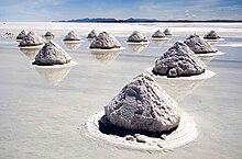
Salar de Uyuni is the world's largest salt flat, or playa, at over 10,000 square kilometres (3,900 sq mi) in area. It is in the Daniel Campos Province in Potosí in southwest Bolivia, near the crest of the Andes at an elevation of 3,656 m (11,995 ft) above sea level.

<span class="mw-page-title-main">Black Rock Desert</span> Northwest Nevada dry lake

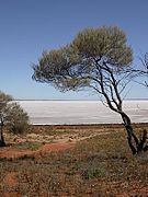
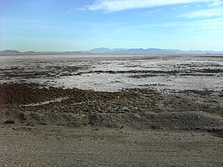
The Black Rock Desert is a semi-arid region of lava beds and playa, or alkali flats, situated in the Black Rock Desert–High Rock Canyon Emigrant Trails National Conservation Area, a silt playa 100 miles (160 km) north of Reno, Nevada that encompasses more than 300,000 acres (120,000 ha) of land and contains more than 120 miles (200 km) of historic trails. It is in the northern Nevada section of the Great Basin with a lakebed that is a dry remnant of Pleistocene Lake Lahontan.

<span class="mw-page-title-main">Endorheic basin</span> Closed drainage basin that allows no outflow

An endorheic basin is a drainage basin that normally retains water and allows no outflow to other, external bodies of water ; instead, the water drainage flows into permanent and seasonal lakes and swamps that equilibrate through evaporation. Endorheic basins also are called closed basins, terminal basins, and internal drainage systems.

<span class="mw-page-title-main">Halite</span> Mineral form of sodium chloride

Halite, commonly known as rock salt, is a type of salt, the mineral (natural) form of sodium chloride (NaCl). Halite forms isometric crystals. The mineral is typically colorless or white, but may also be light blue, dark blue, purple, pink, red, orange, yellow or gray depending on inclusion of other materials, impurities, and structural or isotopic abnormalities in the crystals. It commonly occurs with other evaporite deposit minerals such as several of the sulfates, halides, and borates. The name halite is derived from the Ancient Greek word for "salt", ἅλς (háls).

<span class="mw-page-title-main">Great Basin Desert</span> Desert in the western United States

The Great Basin Desert is part of the Great Basin between the Sierra Nevada and the Wasatch Range. The desert is a geographical region that largely overlaps the Great Basin shrub steppe defined by the World Wildlife Fund, and the Central Basin and Range ecoregion defined by the U.S. Environmental Protection Agency and United States Geological Survey. It is a temperate desert with hot, dry summers and snowy winters. The desert spans large portions of Nevada and Utah, and extends into eastern California. The desert is one of the four biologically defined deserts in North America, in addition to the Mojave, Sonoran, and Chihuahuan Deserts.

<span class="mw-page-title-main">Salt pan (geology)</span> Flat expanse of ground covered with salt and other minerals

Natural salt pans or salt flats are flat expanses of ground covered with salt and other minerals, usually shining white under the sun. They are found in deserts and are natural formations.

In geology, a chott, shott, or shatt is a salt lake in Africa's Maghreb that stays dry for much of the year but receives some water in the winter. The elevation of a chott surface is controlled by the position of the water table and capillary fringe, with sediment deflation occurring when the water table falls and sediment accumulation occurring when the water table rises. They are formed—within variable shores—by the spring thaw from the Atlas mountain range, along with occasional rainwater or groundwater sources in the Sahara, such as the Bas Saharan Basin.

<span class="mw-page-title-main">Salt lake</span> Landlocked body of water which has a high concentration of salts

A salt lake or saline lake is a landlocked body of water that has a concentration of salts and other dissolved minerals significantly higher than most lakes. In some cases, salt lakes have a higher concentration of salt than sea water; such lakes can also be termed hypersaline lakes, and may also be pink lakes on account of their colour. An alkalic salt lake that has a high content of carbonate is sometimes termed a soda lake.

<span class="mw-page-title-main">Badwater Basin</span> Salt-filled basin in Death Valley National Park, containing the lowest point in North America

Badwater Basin is an endorheic basin in Death Valley National Park, Death Valley, Inyo County, California, noted as the lowest point in North America and the United States, with a depth of 282 ft (86 m) below sea level. Mount Whitney, the highest point in the contiguous United States, is only 84.6 miles (136 km) to the northwest.

<span class="mw-page-title-main">Great Salt Lake Desert</span> Large dry lake in northern Utah, United States

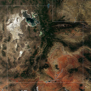
The Great Salt Lake Desert is a large dry lake in northern Utah, United States, between the Great Salt Lake and the Nevada border. It is a subregion of the larger Great Basin Desert, and noted for white evaporite Lake Bonneville salt deposits including the Bonneville Salt Flats.

<span class="mw-page-title-main">Places of interest in the Death Valley area</span>

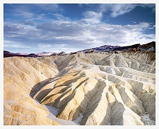
Places of interest in the Death Valley area are mostly located within Death Valley National Park in eastern California.

<span class="mw-page-title-main">Searles Lake</span> Lake in the state of California, United States

Searles Lake is an endorheic dry lake in the Searles Valley of the Mojave Desert, in northwestern San Bernardino County, California. The lake in the past was also called Slate Range Lake and Borax Lake.

<span class="mw-page-title-main">Makgadikgadi Pan</span> Dry lakebed in Botswana

The Makgadikgadi Pan, a salt pan situated in the middle of the dry savanna of north-eastern Botswana, is one of the largest salt flats in the world. The pan is all that remains of the formerly enormous Lake Makgadikgadi, which once covered an area larger than Switzerland, but dried up tens of thousands of years ago. Recent studies of human mitochondrial DNA suggest that modern Homo sapiens first began to evolve in this region some 200,000 years ago, when it was a vast, exceptionally fertile area of lakes, rivers, marshes, woodlands and grasslands especially favorable for habitation by evolving hominins and other mammals.

<span class="mw-page-title-main">Bristol Lake</span> Lake in United States of America

Bristol Lake is a dry lake in the Mojave Desert of San Bernardino County, California, 42 km (26 mi) northeast of Twentynine Palms.

<span class="mw-page-title-main">Sabkha</span> Salt lake above the tide line, where evaporite deposits accumulate

A sabkha is a coastal, supratidal mudflat or sandflat in which evaporite-saline minerals accumulate as the result of semiarid to arid climate. Sabkhas are gradational between land and intertidal zone within restricted coastal plains just above normal high-tide level. Within a sabkha, evaporite-saline minerals sediments typically accumulate below the surface of mudflats or sandflats. Evaporite-saline minerals, tidal-flood, and aeolian deposits characterize many sabkhas found along modern coastlines. The accepted type locality for a sabkha is at the southern coast of the Persian Gulf, in the United Arab Emirates. Evidence of clastic sabkhas are found in the geological record of many areas, including the UK and Ireland. Sabkha is a phonetic transliteration of the Arabic word used to describe any form of salt flat. A sabkha is also known as a sabkhah,sebkha, or coastal sabkha.

<span class="mw-page-title-main">Northern Basin and Range ecoregion</span>

The Northern Basin and Range ecoregion is a Level III ecoregion designated by the United States Environmental Protection Agency (EPA) in the U.S. states of Oregon, Idaho, Nevada, Utah, and California. It contains dissected lava plains, rolling hills, alluvial fans, valleys, and scattered mountain ranges in the northern part of the Great Basin. Although arid, the ecoregion is higher and cooler than the Snake River Plain to the north and has more available moisture and a cooler climate than the Central Basin and Range to the south. Its southern boundary is determined by the highest shoreline of Pleistocene Lake Bonneville, which once inundated the Central Basin and Range. The western part of the region is internally drained; its eastern stream network drains to the Snake River system.

Salt Flat is a ghost town in northeastern Hudspeth County, Texas, United States. It lies along the concurrent U.S. Routes 62 and 180 north of the Census-designated place (CDP) of Sierra Blanca, the county seat of Hudspeth County. Its elevation is 3,730 feet (1,137 m). Although Salt Flat is unincorporated, it has a ZIP Code of 79847. The headquarters of the nearby Guadalupe Mountains National Park uses this ZIP Code although it is located closer to Pine Springs, which has no post office.

<span class="mw-page-title-main">Desert</span> Area of land where little precipitation occurs

A desert is a barren area of landscape where little precipitation occurs and, consequently, living conditions are hostile for plant and animal life. The lack of vegetation exposes the unprotected surface of the ground to denudation. About one-third of the land surface of the Earth is arid or semi-arid. This includes much of the polar regions, where little precipitation occurs, and which are sometimes called polar deserts or "cold deserts". Deserts can be classified by the amount of precipitation that falls, by the temperature that prevails, by the causes of desertification or by their geographical location.

<span class="mw-page-title-main">Endorheic lake</span> Depression within an endorheic basin where water collects with no visible outlet

An endorheic lake is a collection of water within an endorheic basin, or sink, with no evident outlet. Endorheic lakes are generally saline as a result of being unable to get rid of solutes left in the lake by evaporation. These lakes can be used as indicators of anthropogenic change, such as irrigation or climate change, in the areas surrounding them. Lakes with subsurface drainage are considered cryptorheic.

References

  1. Twidale, C.R. & Campbell, E.M. (2005, revised edition): Australian landforms: understanding a low, flat, arid and old landscape. Rosenberg Publishing. Pp. 227, 235, 237, 239. ISBN   1 877058 32 7
  2. "Uyuni Salt Flat" Encyclopædia Britannica
  3. Norris, Richard D.; Norris, James M.; Lorenz, Ralph D.; Ray, Jib; Jackson, Brian (2014-08-27). "Sliding Rocks on Racetrack Playa, Death Valley National Park: First Observation of Rocks in Motion". PLOS ONE. 9 (8): e105948. Bibcode:2014PLoSO...9j5948N. doi: 10.1371/journal.pone.0105948 . PMC   4146553 . PMID   25162535.
  4. "Ice rafts not sails: Floating the rocks at Racetrack Playa" (PDF). Barnesos.net. Retrieved 2016-06-24.
  5. Rogers, D. Christopher; Quinney, Weaver, Olesen (2006). "A New Giant Species of Predatory Fairy Shrimp from Idaho, USA (Branchiopoda: Anostraca)" (PDF). Journal of Crustacean Biology. 26 (1): 1–12. doi: 10.1651/C-2509.1 . Retrieved 2 May 2014.{{cite journal}}: CS1 maint: multiple names: authors list (link)
  6. 1 2 Hagwood, Sheri. "Sensitive Plants of the JRA" (PDF). Idaho BLM. Archived from the original (PDF) on 3 May 2014. Retrieved 2 May 2014.
  7. "CRS Report for Congress: Agriculture: A Glossary of Terms, Programs, and Laws, 2005 Edition - Order Code 97-905" (PDF). Archived from the original (PDF) on August 10, 2011. Retrieved November 30, 2009. A temporary lake created in the lowest elevation of a basin in an arid area that has no surface drain into another water body, such as a perennial stream or river. Lake water is removed either by evaporation into the air or seepage into the ground.
  8. Yao, Fangfang; Livneh, Ben; Rajagopalan, Balaji; Wang, Jida; Crétaux, Jean-François; Wada, Yoshihide; Berge-Nguyen, Muriel (2023-05-19). "Satellites reveal widespread decline in global lake water storage". Science. 380 (6646): 743–749. doi:10.1126/science.abo2812. hdl: 10754/691878 . ISSN   0036-8075. PMID   37200445. S2CID   258765167.
  9. Dickie, Gloria (2023-05-19). "More than half of the world's large lakes are drying up, study finds". Reuters. Retrieved 2023-05-20.

Bibliography