This is a list of the extreme points of Afghanistan .
This is a list of the extreme points of Afghanistan .
Noshaq is the highest point in Afghanistan. [7]
Lowest point in Afghanistan (about 255 m above sea level): The area in the northern end of Khamyab District where the Amu Darya [7] flows into Turkmenistan.

The Mintaka Pass or Mingteke Pass or Mintika Pass(Chinese: 明铁盖达坂) is a mountain pass in the Karakorum Mountains, between Pakistan and Xinjiang in China. In ancient times, the Mintaka Pass and the nearby Kilik Pass, 30 km (19 mi) to the west, were the two main access points into Gojal from the north. The Hunza Valley is the mountainous valley near Gilgit in Gilgit-Baltistan, Pakistan. In addition, the two passes were also the routes used to reach Chalachigu Valley and Taghdumbash Pamir from the south. The name of the pass – Mintaka means "a thousand goats" in Kyrgyz.

Taxkorgan Tajik Autonomous County is an autonomous county of Kashgar Prefecture in Western Xinjiang, China. The county seat is the town of Tashkurgan. The county is the only Tajik autonomous county in China.

Zorkul is a lake in the Pamir Mountains that runs along the border between Afghanistan and Tajikistan.

The Kulma Pass or Qolma Pass, also referred to as Karasu Pass, is a mountain pass across the Pamir Mountains on the border between Murghob District, Gorno-Badakhshan Autonomous Region in Tajikistan and Taxkorgan Tajik Autonomous County, Kashgar Prefecture, Xinjiang Uygur Autonomous Region in China. Asian Highway AH66 runs through the pass, which provides for the only modern day overland border crossing along the 450 km boundary between the two nations.

Akto County is a county in Kizilsu Kyrgyz Autonomous Prefecture, Xinjiang Uygur Autonomous Region, China. The county borders Tajikistan and Kyrgyzstan and has two towns, 11 townships, four state-owned farms and a plant nursery under its jurisdiction with the county seat being Akto Town. The county contains an area of 24,555 km2 (9,481 sq mi) and has a population of 231,756.

Hoboksar, sometimes referred with the historic name Hefeng County, is an autonomous county for Mongol people in the middle north of Xinjiang Uyghur Autonomous Region, Western China, it is under administration of Tacheng Prefecture. The county has an area of 28,784 km2 (11,114 sq mi) with a population of 62,100. It has eight towns and townships and seven farms, Hoboksar Town is its county seat.

Dafdar or Davdar or Daftar or via Mandarin Chinese as Dabuda'er, is a township in the Taghdumbash Pamir located in Tashkurgan Tajik Autonomous County, Kashgar Prefecture, Xinjiang Uyghur Autonomous Region, China. The township is located on the China–Pakistan border. The southern part of the township is located in the Trans-Karakoram Tract claimed by India.
The Beyik Pass, also written and Payik Pass and Bayik Pass, is a mountain pass in the Sarikol Range between Gorno-Badakhshan Autonomous Province in Tajikistan and the Taghdumbash Pamir region of Tashkurgan Tajik Autonomous County in Xinjiang, China. It is situated at an elevation of 4,742 metres (15,558 ft). There is an ethnic Kyrgyz village on the Chinese side with the same name, though the village is more commonly referred to by a different name in Chinese and Beyik is reserved for the border guard outpost.

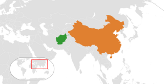
The Afghanistan–China border is a 76-kilometre-long (47 mi) boundary between Afghanistan and China, beginning at the tripoint of both countries with the Pakistan-administrated region of Kashmir (Gilgit-Baltistan), following the watershed along the Mustagh Range, and ending at the tripoint with Tajikistan. This short border is in the far northeast of Afghanistan, distant from much of the country or urban areas in either country, at the end of the long, narrow Wakhan Corridor. The Chinese side of the border is in the Chalachigu Valley. The border is crossed by several mountain passes, including Wakhjir Pass in the south and Tegermansu Pass in the north.

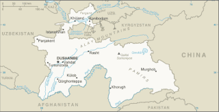
The China–Tajikistan border is 477 km (296 mi) in length and runs from the tripoint with Kyrgyzstan following a roughly north–south line across various mountain ridges and peaks of the Pamir range down to the tripoint with Afghanistan. The border divides Murghob District, Gorno-Badakhshan Autonomous Region in Tajikistan from Akto County, Kizilsu Kyrgyz Autonomous Prefecture and Taxkorgan Tajik Autonomous County, Kashgar Prefecture in Xinjiang Uygur Autonomous Region, China.
Chalachigu Valley or Karachukur Valley is a valley in Taxkorgan Tajik Autonomous County, Kashgar Prefecture, Xinjiang, China. It borders Afghanistan to the west, Tajikistan to the north and Pakistan to the south. It borders Taghdumbash Pamir to the east, Gojal to the south, and Little Pamir to the north and west. The name of the valley is from Kyrgyz meaning "black cave".

The Afghanistan–Tajikistan border is 1,357 km (843 mi) in length and runs from the tripoint with Uzbekistan in the west to the tripoint with China in the east, almost entirely along the Amu Darya, Pyanj and Pamir rivers, except for the easternmost section along the Wakhan Corridor.

Tegermansu Pass or Tigarman Su Pass is a closed mountain pass on the border between Afghanistan and China in Wakhan Corridor, in the Hindu Kush — Pamir mountain range. It is located between the Tegermansu Valley on the eastern end of the Little Pamir and Chalachigu Valley in Xinjiang, China. Historically, it was one of the three routes between China and Wakhan.
Barin Township, also spelled Baren, is a township of Akto County (Aketao), Kizilsu Kyrgyz Autonomous Prefecture (Kezilesu), Xinjiang Uygur Autonomous Region, China. The township is located on the western edge of the Taklamakan Desert at the foot of the Pamir Mountains. Located in the middle west of the northeastern part of the county, the township covers an area of 1,087 square kilometers with a population of 38,706. It has 19 administrative villages under its jurisdiction. Its seat is at Barin Village (巴仁村).
Oytograk is a township in Yutian County (Keriya), Hotan Prefecture, Xinjiang, China.
A bus trip between Kabul and Fayzabad in Badakhshan, Afghanistan’s northernmost province, used to take at least two days.
CHINA-TAJIK BORDER.{...}This mountainous boundary runs along the Sarikol mountain range in eastern Tajikistan, reaching in Pamir the Afghan border at the Povalo-Shveikovskogo peak (5,543 meters above sea level).
Pik Povalo-Shveikovskogo
到高程为5698米的克克拉去考勒峰(阿方图称波万洛什维科夫斯基峰)。
中阿边界{...}南起中、巴、阿3国交界处的5587山峰,沿穆斯塔格山脉分水岭北行至克克拉去考勒峰。
If we open up the Atlas of the People's Republic of China we will find that the region of the Pamir, the western extremity of Xinjiang, from the Wuzibieli [Uzbel] Pass1 to the south down to the Kekelaqukaole Peak (which the Soviet Russians call "Pavel Shveikovsky Peak") is designated as a not limited area.
Elevation:{...} lowest point: Amu Darya 258 m highest point: Noshak 7,492 m