
Lake Mead is a reservoir formed by the Hoover Dam on the Colorado River in the Southwestern United States. It is located in the states of Nevada and Arizona, 24 mi (39 km) east of Las Vegas. It is the largest reservoir in the US in terms of water capacity. Lake Mead provides water to the states of Arizona, California, and Nevada as well as some of Mexico, providing sustenance to nearly 20 million people and large areas of farmland.

St. Thomas, Nevada is a ghost town in Clark County, Nevada, near where the Muddy River flows into the Colorado River. St. Thomas was purchased by the US Federal Government and abandoned as the waters of Lake Mead submerged the town in the 1930s.

Glen and Bessie Hyde were newlyweds who disappeared while attempting to run the rapids of the Colorado River through Grand Canyon, Arizona in 1928. Had the couple succeeded, Bessie Hyde would have been the first woman known to accomplish this feat.
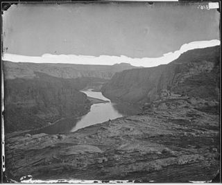
Glen Canyon is a natural canyon carved by a 169.6-mile (272.9 km) length of the Colorado River, mostly in southeastern and south-central Utah, in the United States. Glen Canyon starts where Narrow Canyon ends, at the confluence of the Colorado River and the Dirty Devil River. A small part of the lower end of Glen Canyon extends into northern Arizona and terminates at Lee's Ferry, near the Vermilion Cliffs. Like the Grand Canyon farther downstream, Glen Canyon is part of the immense system of canyons carved by the Colorado River and its tributaries.
Haldane "Buzz" Holmstrom (1909–1946) was a pioneer of running the Colorado River through the Grand Canyon. He was the first person to float all the way from Green River, Wyoming to Boulder Dam solo. He built his own rowboats, often of his own design, to run whitewater rivers.
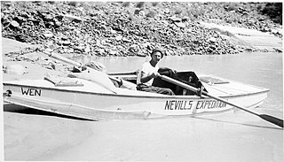
Norman D. Nevills was a pioneer of commercial river-running in the American Southwest, particularly the Colorado River through the Grand Canyon. He led trips including Dr. Elzada Clover and Lois Jotter, the first two women to successfully float the Grand Canyon, and Barry Goldwater.

Ten Who Dared is a 1960 American Western film directed by William Beaudine and starring Brian Keith, Ben Johnson, John Beal and James Drury. It was produced by Walt Disney Productions and released by Buena Vista Distribution. It tells the story of United States Army officer John Wesley Powell, who was the first to travel down the Colorado River, and the dangers that he and nine other men had to face while making a map of the region during their 1869 expedition. Hired by Walt Disney Studios in 1959 as a technical adviser, Otis R. Marston led a film crew through the Grand Canyon to film river running and background scenes for the film.
George Alonzo Johnson (1824–1903) 49er, entrepreneur, and California politician.
Rioville, Nevada was a settlement founded by Latter-day Saints in what they thought was Utah Territory in 1869, now under Lake Mead and within Clark County, Nevada.

Robert Brewster Stanton was a United States civil and mining engineer. He was chief engineer of an expedition investigating the Grand Canyon for a possible railroad line in 1889-90, and investigated many mining properties.

El Dorado Canyon is a canyon in southern Clark County, Nevada famed for its rich silver and gold mines. The canyon was named in 1857 by steamboat entrepreneur Captain George Alonzo Johnson when gold and silver was discovered here. It drains into the Colorado River at the former site of Nelson's Landing.

Callville is a former settlement of Clark County in the U.S. state of Nevada. Abandoned in 1869, it was submerged under Lake Mead when the Colorado River was dammed, Callville Bay retaining the name. At one time, it was noted to be the southernmost outpost of the Mormon settlement.

Steamboats on the Colorado River operated from the river mouth at the Colorado River Delta on the Gulf of California in Mexico, up to the Virgin River on the Lower Colorado River Valley in the Southwestern United States from 1852 until 1909, when the construction of the Laguna Dam was completed. The shallow draft paddle steamers were found to be the most economical way to ship goods between the Pacific Ocean ports and settlements and mines along the lower river, putting in at landings in Sonora state, Baja California Territory, California state, Arizona Territory, New Mexico Territory, and Nevada state. They remained the primary means of transportation of freight until the advent of the more economical railroads began cutting away at their business from 1878 when the first line entered Arizona Territory.
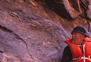
Otis Reed "Dock" Marston was an American writer, historian and Grand Canyon river runner who participated in a large number of river-running firsts. Marston was the eighty-third person to successfully complete the water transit of the Grand Canyon. He spent the last thirty years of his life writing his magnum opus on the history of the first 100 Grand Canyon river runners. In researching his book, he amassed a vast collection of material on early river runners in the American Southwest, especially runners of the Green and Colorado Rivers. His collection is housed in the Huntington Library in San Marino, California.
Ringbolt Rapids are a series of rapids in the upper Black Canyon of the Colorado, 12 miles above the Roaring Rapids in the Colorado River between Arizona and Nevada.
Colorado City is now a ghost town, in Clark County, Nevada, located under Lake Mohave at the mouth of El Dorado Canyon.
Stone's Ferry is a former settlement founded by members of the Church of Jesus Christ of Latter-day Saints and ferry crossing of the Colorado River between Nevada and Arizona, in Clark County, Nevada, United States.
Boulder Canyon, originally Devils Gate Canyon, is a canyon on the Colorado River, above Hoover Dam, now flooded by Lake Mead. It lies between Clark County, Nevada and Mohave County, Arizona. It heads at western end of the Virgin River Basin of Lake Mead, at about 36°09′05″N114°32′51″W. Boulder Canyon divides the Black Mountains into the Black Mountains of Arizona, and the Black Mountains of Nevada. Its mouth is now under the eastern end of the Boulder Basin of Lake Mead, between Canyon Point in Nevada and Canyon Ridge in Arizona. Its original mouth is now underneath Lake Mead between Beacon Rock and Fortification Ridge on the southern shore in Arizona.

Diamond Peak is a 3,512-foot-elevation summit located in the western end of the Grand Canyon, on the Hualapai Indian Reservation in Mohave County of northwestern Arizona, United States. This double summit landmark is situated at the mouth of Peach Springs Canyon, where Diamond Creek meets the Colorado River. This peak is an erosional remnant composed of Cambrian Muav Limestone and Mississippian Redwall Limestone. Topographic relief is significant as Diamond Peak towers 2,200 feet above the Colorado River in one-half mile. According to the Köppen climate classification system, Diamond Peak is located in a desert climate zone.


