Clark County is located in the U.S. state of Nevada. As of the 2020 census, the population was 2,265,461. Most of the county population resides in the Las Vegas Census County Divisions, which hold 1,771,945 people as of the 2010 Census, across 476 square miles (1,233 km2). It is by far the most populous county in Nevada, and the 11th most populous county in the United States. It covers 7% of the state's land area but holds 74% of the state's population, making Nevada one of the most centralized states in the United States.

The Red Rock Canyon National Conservation Area in Clark County, Nevada, is an area managed by the Bureau of Land Management as part of its National Landscape Conservation System, and protected as a National Conservation Area. It is about 15 miles (24 km) west of Las Vegas, and is easily seen from the Las Vegas Strip. More than three million people visit the area each year.

Lake Mead is a reservoir formed by the Hoover Dam on the Colorado River in the Southwestern United States. It is located in the states of Nevada and Arizona, 24 mi (39 km) east of Las Vegas. It is the largest reservoir in the US in terms of water capacity. Lake Mead provides water to the states of Arizona, California, and Nevada as well as some of Mexico, providing sustenance to nearly 20 million people and large areas of farmland.

The Las Vegas Valley is a major metropolitan area in the southern part of the U.S. state of Nevada, and the second largest in the Southwestern United States. The state's largest urban agglomeration, the Las Vegas Metropolitan Statistical Area is coextensive since 2003 with Clark County, Nevada. The Valley is largely defined by the Las Vegas Valley landform, a 600 sq mi (1,600 km2) basin area surrounded by mountains to the north, south, east and west of the metropolitan area. The Valley is home to the three largest incorporated cities in Nevada: Las Vegas, Henderson and North Las Vegas. Eleven unincorporated towns governed by the Clark County government are part of the Las Vegas Township and constitute the largest community in the state of Nevada.

The Amargosa River is an intermittent waterway, 185 miles (298 km) long, in southern Nevada and eastern California in the United States. It drains a high desert region, the Amargosa Valley in the Amargosa Desert northwest of Las Vegas, into the Mojave Desert, and finally into Death Valley where it disappears into the ground aquifer. Except for a small portion of its route in the Amargosa Canyon in California and a small portion at Beatty, Nevada, the river flows above ground only after a rare rainstorm washes the region. A 26-mile (42 km) stretch of the river between Shoshone and Dumont Dunes is protected as a National Wild and Scenic River. At the south end of Tecopa Valley the Amargosa River Natural Area protects the habitat.

The Spring Mountains are a mountain range of Southern Nevada in the United States, running generally northwest–southeast along the west side of Las Vegas and south to the border with California. Most land in the mountains is owned by the United States Forest Service and the Bureau of Land Management and managed as the Spring Mountains National Recreation Area within the Humboldt-Toiyabe National Forest and the Red Rock Canyon National Conservation Area.

State Route 156, also known as Lee Canyon Road, is a state highway in Clark County, Nevada. The road is one of two highways connecting U.S. Route 95 to the Humboldt-Toiyabe National Forest and Spring Mountains area northwest of Las Vegas and its entire length is designated a Nevada Scenic Byway.
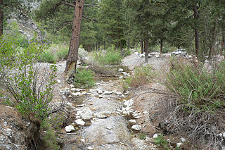
Carpenter Canyon is a canyon on the western side of the Spring Mountains, partially within the Humboldt-Toiyabe National Forest, in Clark County, southern Nevada west of the Las Vegas Valley.

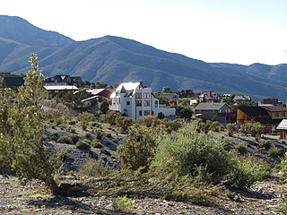
Mountain Springs is an unincorporated community in Clark County in southern Nevada. It is located in Mountain Springs Summit, the pass over the Spring Mountains through which Highway 160 connects Las Vegas and Pahrump. Public buildings include a fire house and a saloon.
The Clark County Regional Flood Control District (CCRFCD) was created in 1985 by the Nevada Legislature allowing Clark County to provide broad solutions to flooding problems. The District has developed plans and so far successfully continued working on a 50-year program to eliminate most flooding from a 100-year flood in the populated areas for which the CCRFCD is responsible.

Nelson is a census-designated place in Clark County, Nevada, United States. The community is in the Pacific Standard Time zone. The location of Nelson is in El Dorado Canyon, Eldorado Mountains. The town is in the southeast region of the Eldorado Valley. As of the 2010 census it had a population of 37.
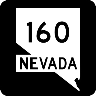
State Route 160 is a state highway in southern Nevada, United States. It connects the southern Las Vegas Valley to U.S. Route 95 northwest of the city via the Pahrump Valley. The southern part of the route sees heavy traffic, mostly due to Pahrump's continued growth as a Las Vegas bedroom community.

Coyote Springs, Nevada, is a master-planned community being developed in Lincoln County and Clark County, Nevada. The community was initially planned by developer and attorney-lobbyist Harvey Whittemore and Pardee Homes. Thomas Seeno and Albert Seeno, Jr. became the sole owners of Coyote Springs following Whittemore's resignation from the Wingfield Nevada Holding Group amidst legal troubles. No homes had been built as of June 2018.

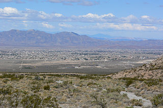
Pahrump is an unincorporated town located at the southernmost tip of Nye County, Nevada, United States, about 62 miles (100 km) west of Las Vegas, Nevada. Pahrump lies adjacent to the Nevada–California border and the area had a population of 44,738 as of the 2020 census.
Pahrump Valley is a Mojave Desert valley west of Las Vegas and the Spring Mountains massif in southern Nye County, Nevada, and eastern San Bernardino County, California. Pahrump, Nevada, is in the valley's center and the Tecopa and Chicago Valleys are immediately to the west. The valley has routes to Death Valley and a route to Las Vegas. Pahrump Valley Days is the annual event in February each year, along with the sanctioned JRH-HS Rodeo.

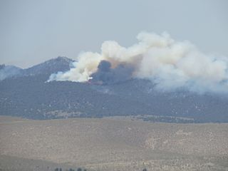
The Carpenter 1 Fire was a large wildfire on Mount Charleston, 25 miles (40 km) northwest of Las Vegas, Nevada. The fire began on July 1, 2013, near Pahrump, Nevada, before spreading eastward. Carpenter 1 was seen for miles across the Las Vegas metropolitan area, and was the largest fire to occur on Mount Charleston in decades. After eight weeks of battling the fire, Carpenter 1 was fully contained on August 18, 2013. The fire consumed nearly 28,000 acres (11,000 ha), causing parts of Nevada State Route 156 and 157 to be closed. This resulted in the evacuation of residents and closure of businesses and portions of the Spring Mountains National Recreation Area. The fire, stretching between 5,000–11,000 feet (1,500–3,400 m) elevations, was fought by hundreds of firefighters and eight hotshot crews, as well as helicopters, fire engines, water tenders, and a DC-10 tanker plane. According to the National Interagency Fire Center, the Carpenter 1 fire was considered "the highest ranked priority fire in the nation" at the time of its occurrence. Evidence of the damage can still be seen on the South Loop Trail to Charleston Peak.
The Strawberry Fire was a wildfire, that burned in the northern Great Basin National Park in White Pine County, Nevada in August 2016. The wildfire was caused by a lightning strike, and was reported a few days later on August 8. The Strawberry Fire was contained eleven days later. It burned 4,714 acres (1,908 ha) of land, of which sixty percent is part of Great Basin National Park. An additional 38% of the land is located in the Ely District of the Bureau of Land Management. It was the first major wildfire in the national park since 2013. One fireman died while helping to put out the wildfire. The fire also damaged a campground and the habitat of the Bonneville cutthroat trout.
The January 2018 American West floods occurred due to heavy precipitation in the Western United States. While wildfires in Southern California exacerbated the rain's effects there, other states, like Nevada, also experienced flooding.
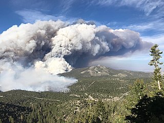
The Mahogany Fire was a wildfire that burned on Mount Charleston in the Spring Mountains National Recreation Area, approximately 50 miles northwest of Las Vegas, Nevada in the United States. The fire was first reported on June 28, 2020. The fire burned a total of 2,758 acres (1,116 ha) and was contained on July 7, 2020. The cause of the fire remains under investigation. The fire impacted recreational activities and roadways in the area, including closing a children's summer camp and evacuating Lee Canyon. Additionally, three state highways were closed in the area to allow ease of access for crews and to limit the public's access to the fire area.
Cold Creek is an unincorporated community in Clark County, Nevada, United States located within the Spring Mountains National Recreation Area and approximately 28 miles by road from the Las Vegas city limits. Cold Creek is named for the stream that flows through the community.