Eureka County, Nevada

Last updated

Eureka County
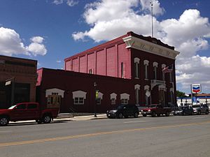
2014-09-09 13 11 16 The Eureka County Court House on U.S. Route 50 in Eureka, Nevada.JPG
Map of Nevada highlighting Eureka County.svg
Location within the U.S. state of Nevada
Nevada in United States.svg
Nevada's location within the U.S.
Coordinates: 39°59′N116°16′W / 39.98°N 116.27°W / 39.98; -116.27
CountryFlag of the United States.svg United States
StateFlag of Nevada.svg  Nevada
Founded1873;151 years ago (1873)
Named for Eureka
Seat Eureka
Largest community Crescent Valley
Area
  Total4,180 sq mi (10,800 km2)
  Land4,176 sq mi (10,820 km2)
  Water4.3 sq mi (11 km2)  0.1%
Population
 (2020)
  Total1,855
  Density0.44/sq mi (0.17/km2)
Time zone UTC−8 (Pacific)
  Summer (DST) UTC−7 (PDT)
Congressional district 2nd
Website co.eureka.nv.us

Eureka County is a county in the U.S. state of Nevada. As of the 2020 census, the population was 1,855, [1] making it the second-least populous county in Nevada. Its county seat is Eureka. [2]

Contents

Eureka County is part of the Elko Micropolitan Statistical Area.

History

Eureka County was established in 1873 and formed from Lander County after silver was discovered more than 100 miles (160 km) east of Austin. The new mining camp's residents complained Austin was too far to go for county business and a new county was created. It was named for the ancient Greek term, Eureka , meaning, "I have found it." [3] This term was used earlier in California and other locations. Eureka has always been the county seat.

Geography

HVAC transmission towers crossing Crescent Valley east of State Route 306 A342, Crescent Valley, Nevada, USA, high-voltage AC transmission towers, 2011.jpg
HVAC transmission towers crossing Crescent Valley east of State Route 306

According to the U.S. Census Bureau, the county has an area of 4,180 square miles (10,800 km2), of which 4,176 square miles (10,820 km2) is land and 4.3 square miles (11 km2) (0.1%) is water. [4]

The county's highest point is the 10,631 ft (3,240 m) summit of Diamond Peak in the Diamond Mountains along the border with White Pine County. [5]

Adjacent counties

National protected area

Major highways

Demographics

Historical population
CensusPop.Note
1880 7,086
1890 3,275−53.8%
1900 1,954−40.3%
1910 1,830−6.3%
1920 1,350−26.2%
1930 1,333−1.3%
1940 1,3612.1%
1950 896−34.2%
1960 767−14.4%
1970 94823.6%
1980 1,19826.4%
1990 1,54729.1%
2000 1,6516.7%
2010 1,98720.4%
2020 1,855−6.6%
2023 (est.)1,917 [6] 3.3%
U.S. Decennial Census [7]
1790-1960 [8] 1900-1990 [9]
1990-2000 [10] 2010-2018 [1]

2000 census

At the 2000 census there were 1,651 people, 666 households, and 440 families living in the county. The population density was 0.39 people per square mile (0.15 people/km2). There were 1,025 housing units at an average density of 0.25 units per square mile (0.097/km2). [11] Of the 666 households 33.00% had children under the age of 18 living with them, 56.50% were married couples living together, 5.00% had a female householder with no husband present, and 33.90% were non-families. 29.10% of households were one person and 9.90% were one person aged 65 or older. The average household size was 2.47 and the average family size was 3.08.

The age distribution was 27.80% under the age of 18, 5.20% from 18 to 24, 28.60% from 25 to 44, 25.90% from 45 to 64, and 12.40% 65 or older. The median age was 38 years. For every 100 females, there were 106.60 males. For every 100 females age 18 and over, there were 113.20 males.

The county's median household income was $41,417, and the median family income was $49,438. Males had a median income of $45,167 versus $25,000 for females. The county's per capita income was $18,629. 12.60% of the population and 8.90% of families were below the poverty line. Out of the people living in poverty, 11.70% are under the age of 18 and 16.40% are 65 or older.

2010 census

At the 2010 census, there were 1,987 people, 836 households, and 495 families living in the county. [12] The population density was 0.5 inhabitants per square mile (0.19/km2). There were 1,076 housing units at an average density of 0.3 units per square mile (0.12 units/km2). [13] The racial makeup of the county was 89.3% white, 2.4% American Indian, 0.9% Asian, 0.1% black or African American, 5.1% from other races, and 2.2% from two or more races. Those of Hispanic or Latino origin made up 12.0% of the population. [12] In terms of ancestry, 43.3% were American, 14.8% were German, 11.4% were Irish, 7.3% were English, and 6.9% were Italian. [14]

Of the 836 households, 27.3% had children under the age of 18 living with them, 51.6% were married couples living together, 4.2% had a female householder with no husband present, 40.8% were non-families, and 33.0% of households were made up of individuals. The average household size was 2.38 and the average family size was 3.07. The median age was 42.4 years. [12]

The median household income was $61,400 and the median family income was $75,179. Males had a median income of $54,625 versus $42,321 for females. The per capita income for the county was $30,306. About 9.9% of families and 16.2% of the population were below the poverty line, including 23.6% of those under age 18 and 13.9% of those age 65 or over. [15]

Communities

There are no incorporated places in Eureka County.

Census-designated places

Unincorporated communities

Ghost towns

Education

Eureka County School District is the county school district.

Politics

Background

Eureka County is strongly Republican; the last time they voted for a Democratic candidate was in 1964, and the last time a Democratic candidate received a quarter of the county's vote was in 1988. The last time a Republican candidate failed to receive a majority of the county's vote was in 1992, when the vote was somewhat split when independent candidate Ross Perot recorded approximately a third of the county's vote.

However, due to the county's low population, its heavy Republican voting does not have a large effect on elections in the state, as a majority of Nevada's population live in Democratic-leaning Clark County and Washoe County.

United States presidential election results for Eureka County, Nevada [16]
Year Republican Democratic Third party
No.%No.%No.%
2020 89588.00%10510.32%171.67%
2016 72384.66%748.67%576.67%
2012 66382.05%10713.24%384.70%
2008 56475.70%14419.33%374.97%
2004 57177.37%14419.51%233.12%
2000 63275.51%15017.92%556.57%
1996 41259.88%15822.97%11817.15%
1992 33047.83%12918.70%23133.48%
1988 41370.96%15125.95%183.09%
1984 43975.95%12421.45%152.60%
1980 43076.24%10318.26%315.50%
1976 27258.24%16334.90%326.85%
1972 37172.75%13927.25%00.00%
1968 27756.53%14930.41%6413.06%
1964 24346.02%28553.98%00.00%
1960 23951.73%22348.27%00.00%
1956 33064.33%18335.67%00.00%
1952 37970.71%15729.29%00.00%
1948 31251.74%27846.10%132.16%
1944 31759.36%21740.64%00.00%
1940 28444.58%35355.42%00.00%
1936 18031.25%39668.75%00.00%
1932 13626.10%38573.90%00.00%
1928 25149.02%26150.98%00.00%
1924 20950.00%9422.49%11527.51%
1920 31363.75%15731.98%214.28%
1916 23945.96%26350.58%183.46%
1912 7016.51%20949.29%14534.20%
1908 22446.57%21845.32%398.11%
1904 23562.50%10728.46%349.04%

See also

Related Research Articles

<span class="mw-page-title-main">Eureka, Missouri</span> A city in St. Louis County and Jefferson County, Missouri

Eureka is a city in St. Louis County and Jefferson County, Missouri, adjacent to Wildwood and Pacific. It is in the extreme southwest of the Greater St. Louis metro area. As of the 2020 census, the city had a population of 11,646. Since 1971, Eureka has been known as the home of the amusement park Six Flags St. Louis.

<span class="mw-page-title-main">Douglas County, Nevada</span> County in Nevada, United States

Douglas County is a county in the northwestern part of the U.S. state of Nevada. As of the 2020 census, the population was 49,488. Its county seat is Minden. Douglas County comprises the Gardnerville Ranchos, NV Micropolitan Statistical Area, which is also included in the Reno–Carson City–Fernley, NV Combined Statistical Area.

<span class="mw-page-title-main">Washakie County, Wyoming</span> County in Wyoming, United States

Washakie County is a county in the U.S. state of Wyoming. As of the 2020 United States Census, the population was 7,685. Its county seat is Worland.

<span class="mw-page-title-main">Walla Walla County, Washington</span> County in Washington, United States

Walla Walla County is a county located in the U.S. state of Washington. As of the 2020 census, its population was 62,584. The county seat and largest city is Walla Walla. The county was formed on April 25, 1854 and is named after the Walla Walla tribe of Native Americans.

<span class="mw-page-title-main">White Pine County, Nevada</span> County in Nevada, United States

White Pine County is a largely rural, mountain county along the central eastern boundary of the U.S. state of Nevada. As of the 2020 census, the population was 9,080. Its county seat is Ely. The name "(Rocky Mountain) white pine" is an old name for the limber pine, a common tree in the county's mountains.

<span class="mw-page-title-main">Pershing County, Nevada</span> County in Nevada, United States

Pershing County is a county in the U.S. state of Nevada. As of the 2020 census, the population was 6,650. Its county seat is Lovelock. The county was named after army general John J. Pershing (1860–1948). It was formed from Humboldt County in 1919, and the last county to be established in Nevada. The Black Rock Desert, location for the annual Burning Man event, is partially in the county. The county is listed as Nevada Historical Marker 17. The marker is at the courthouse in Lovelock.

<span class="mw-page-title-main">Storey County, Nevada</span> County in Nevada, United States

Storey County is a county located in the U.S. state of Nevada. As of the 2020 census, the population was 4,104, making it the third-least populous county, but one of the fastest-growing economies in Nevada. In 2018, over 18,000 people were employed in the county. Its area is 264 square miles, making it the smallest county in Nevada in terms of area. Its county seat is Virginia City. Storey County is part of the Reno-Sparks metropolitan area.
<span class="mw-page-title-main">Nye County, Nevada</span> County in Nevada, United States

Nye County is a county in the U.S. state of Nevada. As of the 2020 census, the population was 51,591. Its county seat is Tonopah. At 18,159 square miles (47,030 km2), Nye is Nevada's largest county by area and the third-largest county in the contiguous United States, behind Coconino County of Arizona and San Bernardino County of California.

<span class="mw-page-title-main">Mineral County, Nevada</span> County in Nevada, United States

Mineral County is a county located in the U.S. state of Nevada. As of the 2020 census, the population was 4,554, making it the fifth-least populous county in Nevada. Its county seat is Hawthorne.

<span class="mw-page-title-main">Lander County, Nevada</span> County in Nevada, United States

Lander County is a county in the U.S. state of Nevada. As of the 2020 census, the population was 5,734. Its county seat is Battle Mountain.
<span class="mw-page-title-main">Elko County, Nevada</span> County in Nevada, United States

Elko County is a county in the northeastern corner of Nevada, United States. As of the 2020 census, the population was 53,702. Its county seat is Elko. The county was established on March 5, 1869, from Lander County.
<span class="mw-page-title-main">Plumas Eureka, California</span> Census-designated place in California, United States

Plumas Eureka is a census-designated place (CDP) in Plumas County, California, United States. The population was 320 at the 2000 census.

<span class="mw-page-title-main">Climax, Kansas</span> City in Greenwood County, Kansas

Climax is a city in Greenwood County, Kansas, United States. As of the 2020 census, the population of the city was 45.
<span class="mw-page-title-main">Eureka, Kansas</span> City in Greenwood County, Kansas

Eureka is a city in and the county seat of Greenwood County, Kansas, United States. As of the 2020 census, the population of the city was 2,332.

<span class="mw-page-title-main">Harwood, Missouri</span> Village in Missouri, United States

Harwood is a village in northeast Vernon County, Missouri, United States. The population was 47 at the 2010 census. It was estimated to be 45 by the City of Harwood as of July 1, 2019.

<span class="mw-page-title-main">Gardnerville Ranchos, Nevada</span> Census-designated place in Nevada, United States

Gardnerville Ranchos is a census-designated place in Douglas County, Nevada, United States. As of the 2010 census, the population was 11,312. The area is the namesake for the Gardnerville Ranchos Micropolitan Statistical area which includes other areas of Douglas County.

Sun Valley is a census-designated place (CDP) in Washoe County, Nevada, United States. The population was 19,299 at the 2010 census. It is north of Reno and is part of the Reno–Sparks Metropolitan Statistical Area.

<span class="mw-page-title-main">Sand Fork, West Virginia</span> Town in West Virginia, United States

Sand Fork is a town in Gilmer County, West Virginia, United States. The population was 182 at the 2020 census. It is located along the Little Kanawha River, at the mouth of the Sand Fork.

<span class="mw-page-title-main">Eureka, Polk County, Wisconsin</span> Town in Wisconsin, United States

Eureka is a town in Polk County, Wisconsin, United States. The population was 1,338 at the 2000 census. The unincorporated community of Eureka Center is located in the town.

<span class="mw-page-title-main">North English, Iowa</span> City in Iowa, United States

North English is a city located mainly in Iowa county with a small portion in Keokuk county in the U.S. state of Iowa. The population was 1,065 at the time of the 2020 census. It is named for the English River.
References

  1. 1 2 "State & County QuickFacts". United States Census Bureau. Archived from the original on June 6, 2011. Retrieved September 23, 2013.
  2. "County Explorer". National Association of Counties. Retrieved June 7, 2011.
  3. Gannett, Henry (1905). The Origin of Certain Place Names in the United States. Govt. Print. Off. p.  122 . Retrieved January 1, 2016.
  4. "2010 Census Gazetteer Files". United States Census Bureau. August 22, 2012. Retrieved December 20, 2014.
  5. "Diamond Peak, Nevada". Peakbagger.com. Retrieved October 6, 2014.
  6. "Annual Estimates of the Resident Population for Counties: April 1, 2020 to July 1, 2023". United States Census Bureau. Retrieved March 26, 2024.
  7. "U.S. Decennial Census". United States Census Bureau. Retrieved December 20, 2014.
  8. "Historical Census Browser". University of Virginia Library. Retrieved December 20, 2014.
  9. "Population of Counties by Decennial Census: 1900 to 1990". United States Census Bureau. Retrieved December 20, 2014.
  10. "Census 2000 PHC-T-4. Ranking Tables for Counties: 1990 and 2000" (PDF). United States Census Bureau. Archived (PDF) from the original on March 27, 2010. Retrieved December 20, 2014.
  11. "U.S. Census website". United States Census Bureau . Retrieved January 31, 2008.
  12. 1 2 3 "DP-1 Profile of General Population and Housing Characteristics: 2010 Demographic Profile Data". United States Census Bureau. Archived from the original on February 13, 2020. Retrieved January 21, 2016.
  13. "Population, Housing Units, Area, and Density: 2010 - County". United States Census Bureau. Archived from the original on February 13, 2020. Retrieved January 21, 2016.
  14. "DP02 SELECTED SOCIAL CHARACTERISTICS IN THE UNITED STATES – 2006-2010 American Community Survey 5-Year Estimates". United States Census Bureau. Archived from the original on February 13, 2020. Retrieved January 21, 2016.
  15. "DP03 SELECTED ECONOMIC CHARACTERISTICS – 2006-2010 American Community Survey 5-Year Estimates". United States Census Bureau. Archived from the original on February 13, 2020. Retrieved January 21, 2016.
  16. Leip, David. "Dave Leip's Atlas of U.S. Presidential Elections". uselectionatlas.org. Retrieved April 12, 2018.

39°59′N116°16′W / 39.98°N 116.27°W / 39.98; -116.27