
Clark County is a county located in the U.S. state of Nevada. As of the 2020 census, the population was 2,265,461. Most of the county population resides in the Las Vegas Census County Divisions, which hold 2,196,623 people as of the 2020 Census, across 435 square miles (1,130 km2). It is by far the most populous county in Nevada, and the 11th most populous county in the United States. It covers 7% of the state's land area but holds 73% of the state's population, making Nevada the most centralized state in the United States.

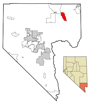
Mesquite is a city in Clark County, Nevada, United States adjacent to the Arizona state line and 80 miles (130 km) northeast of Las Vegas on Interstate 15. As of the 2020 census, the city had a population of 20,471. The city is located in the Virgin River valley adjacent to the Virgin Mountains in the northeastern part of the Mojave Desert. It is home to a growing retirement community, as well as several casino resorts and golf courses.
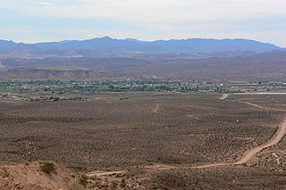
Moapa Valley is an unincorporated town in Clark County, Nevada, United States. As of the 2010 census, it had a population of 6,924. The valley in which the community lies, also named Moapa Valley, is about 40 miles (64 km) long and lies roughly northwest to southeast.
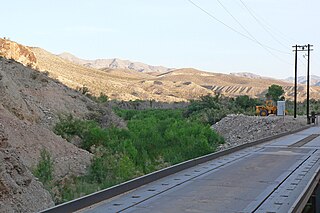
The Meadow Valley Wash is a southern Nevada stream draining the Meadow Watershed that is bordered on three sides by the Great Basin Divide. The wash's Lincoln County head point is in the Wilson Creek Range, and the wash includes two upper confluences. Panaca is along the upper wash, and downstream of Caliente is the wash's confluence with its east fork. Just before the junction with the Muddy River, the wash flows from Lincoln County into northeastern Clark County. It flows into the Muddy in the Moapa Valley just west of Glendale adjacent to Interstate 15 approximately 40 miles (64 km) northeast of Las Vegas.
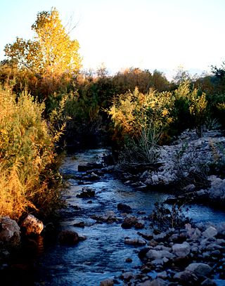
The Muddy River, formerly known as the Moapa River, is a short river located in Clark County, in southern Nevada, United States. It is in the Mojave Desert, approximately 60 miles (97 km) north of Las Vegas.

Logandale is located in Clark County, Nevada. It was an unincorporated town in Clark County until 1981 when it was merged with Overton to create the unincorporated town of Moapa Valley. The community is the home of the annual Clark County Fair and Rodeo. The Las Vegas Metropolitan Police Department patrols the town.
Overton is a community that is part of the unincorporated town of Moapa Valley in Clark County, Nevada. Overton is on the north end of Lake Mead. It is home to Perkins Field airport and Echo Bay Airport.

The Moapa Valley National Wildlife Refuge (MVNWR) is a protected wildlife refuge administered by the U.S. Fish and Wildlife Service, located in the Warm Springs Natural Area in the Moapa Valley of Clark County, Nevada. The refuge is east of Death Valley and 60 miles (97 km) northeast of Las Vegas, Nevada.

The Mormon Mountains are located in Lincoln and Clark counties in Nevada, between 16 and 28 miles (45 km) northwest of Mesquite on I–15 in the Virgin Valley, east of the Meadow Valley Mountains and Meadow Valley and northeast of Moapa Valley. The highest point in the range is Mormon Peak, at 7,414 feet (2,260 m) above sea level. Another smaller mountain range lies to the east, called the East Mormon Mountains. The south fork of the Toquop Wash drains the east side of the range and continues on through the N–S linear ridge of the East Mormon Mountains.
Glendale is an unincorporated community in Clark County, Nevada, United States. The community is at an elevation of 1,519 feet (463 m).

State Route 169 is a state highway in Clark County, Nevada, United States. It connects the northern reaches of Lake Mead National Recreation Area to Interstate 15 (I-15) via Moapa Valley and the communities of Overton and Logandale. It is also called Northshore Road, Moapa Valley Boulevard, and Logandale Road.
Clark County Fair and Rodeo is in Logandale, Nevada, next to Grant M. Bowler Elementary School in Clark County, Nevada. It's an annual fair and rodeo.
The Las Vegas–Henderson combined statistical area, known prior to 2013 as the Las Vegas–Paradise–Pahrump combined statistical area, is made up of two counties in southern Nevada and one in northwestern Arizona. The statistical area consists of the Las Vegas–Paradise, NV MSA, the Lake Havasu City–Kingman, AZ MSA and the Pahrump micropolitan statistical area. At the 2010 census, the CSA had a population of 2,195,401.

The Meadow Valley Mountains is a mountain range in Lincoln and Clark counties in southern Nevada. The range is a narrow north to northeast trending ridgeline with a length of about 40 miles (64 km). The Clover Mountains lie to the north, Meadow Valley Wash and the Mormon Mountains to the east, the Moapa Valley to the southeast, Arrow Canyon Range to the south, Coyote Springs Valley to the southwest and the Kane Springs Valley and Delamar Mountains to the west and northwest.

The Warm Springs Natural Area, also known as the Warm Springs Ranch, is located near the Moapa Indian Reservation in Clark County, Nevada, at an elevation of 2,123 feet (647 m). The 1,179-acre (477 ha) area is owned by the Southern Nevada Water Authority (SNWA). The area is a natural oasis in the Mojave Desert. The oasis is fed by close to 24 natural warm springs and contains many naturally occurring California fan palms, creating an ecosystem normally limited to the "low" Colorado Desert and so unique to the "high" Mojave Desert. The springs are the headwaters for the Muddy River.
Crystal is a former unincorporated community in Clark County, Nevada, United States. It lies along the Union Pacific Railroad and had a population of 10 in 1941. It is now the site of a highway rest stop.

LDS Moapa Stake Office Building, also known as the Virmoa Maternity Hospital, is listed on the National Register of Historic Places in Overton, Nevada. It was built between 1917 and 1919 to serve the community of Moapa Valley as a local office, classroom and records repository for the LDS Church. In 1939, the local stake decided to relocate their offices to Las Vegas as travel between the communities became easier. The building then sat vacant.

Moapa Valley High School is a 3A public high school in Overton, Nevada, United States and is part of the Clark County School District (CCSD). It has an approximated number of students of 562. The school mascot is the pirate.
Saint Joseph is a ghost town in Clark County, Nevada, that was located on the east bank of the Muddy River west of the north end of the Perkins Field in the Moapa Valley.
The Moapa Southern Paiute Solar Project is a 250 megawatt (MWAC) photovoltaic power plant located in Clark County, Nevada on the Moapa River lands of the Southern Paiute people. The project was commissioned in March 2017 and was constructed by First Solar and its sub-contractors in close consultation with the Moapa Band of Paiutes and federal agencies. It is the first utility-scale solar project to be located on North American tribal lands, and is anticipated to evolve as a model for similar future economic and environmental partnerships.


